Property Record
3111 N 10Th St, Mcallen, TX 78501


Property Detail
3111 N 10Th St
McAllen-Edinburg-Mission, TX
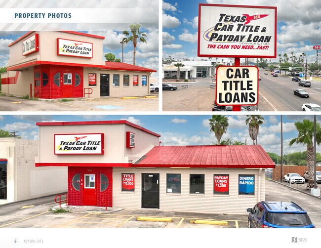
RED LINE BURGERS LOT A
R1345-00-000-000A-00
Hidalgo
Officebuilding
Texas
RS
a
2024
0.52 AC
2025
Greater McAllen
020806
McAllen/Edinburg/Pharr
1,544 SF
NEARBY LISTINGS FOR SALE OR LEASE
DEMOGRAPHICS near 3111 N 10Th St
1 mile
3 mile
5 mile
2025 Total Population
14,545
110,188
253,474
2030 Population
14,997
114,433
264,883
Pop Growth 2025-2030
+ 3.11%
+ 3.85%
+ 4.50%
Average Age
38
37
36
2025 Total Households
5,571
38,589
84,084
HH Growth 2025-2030
+ 2.93%
+ 3.75%
+ 4.44%
Median Household Inc
$67,177
$58,590
$61,141
Avg Household Size
2.50
2.80
2.90
2025 Avg HH Vehicles
2.00
2.00
2.00
Median Home Value
$203,105
$191,464
$196,306
Median Year Built
1980
1992
1997
Nearby Places
Map Layers
Map Styles
 Street
 Aerial
Layers
 Traffic
 Biking
Places
Listings with unknown addresses are not visible on the map
- Restaurants
- Banks
- Shops
- Fitness
- Groceries
PUBLIC TRANSPORTATION
AIRPORT
McAllen International
Drive
Walk
Distance
McAllen International
8 min
4.0 mi
SALE & LEASE HISTORY
LISTING DATE
SALE/LEASE

Oct 06, 2021
For Sale
May 10, 2022
For Sale
Nearby Properties
Address
Land Use
TOTAL SIZE
Lot Size
Zoning
Address
Land Use
TOTAL SIZE
Lot Size
Zoning
407,190 SF
11.04 AC
CO
Address
Land Use
TOTAL SIZE
Lot Size
Zoning
357,818 SF
11.10 AC
Address
Land Use
TOTAL SIZE
Lot Size
Zoning
390,048 SF
30.30 AC
Address
Land Use
TOTAL SIZE
Lot Size
Zoning
165,620 SF
24.44 AC
Address
Land Use
TOTAL SIZE
Lot Size
Zoning
18 SF
82.24 AC
Address
Land Use
TOTAL SIZE
Lot Size
Zoning
263,388 SF
37.48 AC
Address
Land Use
TOTAL SIZE
Lot Size
Zoning
235,545 SF
40.51 AC
Address
Land Use
TOTAL SIZE
Lot Size
Zoning
1 SF
9.36 AC
Address
Land Use
TOTAL SIZE
Lot Size
Zoning
251,423 SF
27.39 AC
CO
Address
Land Use
TOTAL SIZE
Lot Size
Zoning
191,978 SF
2.22 AC
Address
Land Use
TOTAL SIZE
Lot Size
Zoning
252,435 SF
9.09 AC
Address
Land Use
TOTAL SIZE
Lot Size
Zoning
128,076 SF
5.01 AC
Address
Land Use
TOTAL SIZE
Lot Size
Zoning
125,254 SF
15 AC
C
Address
Land Use
TOTAL SIZE
Lot Size
Zoning
254,477 SF
51.88 AC
Address
Land Use
TOTAL SIZE
Lot Size
Zoning
79,150 SF
10.24 AC
Address
Land Use
TOTAL SIZE
Lot Size
Zoning
208,113 SF
22.75 AC
Address
Land Use
TOTAL SIZE
Lot Size
Zoning
123,548 SF
10.70 AC
Address
Land Use
TOTAL SIZE
Lot Size
Zoning
135,948 SF
2.87 AC
Address
Land Use
TOTAL SIZE
Lot Size
Zoning
173,217 SF
5.58 AC
Address
Land Use
TOTAL SIZE
Lot Size
Zoning
121,353 SF
4.59 AC
Address
Land Use
TOTAL SIZE
Lot Size
Zoning
40,248 SF
10.36 AC
Address
Land Use
TOTAL SIZE
Lot Size
Zoning
66,605 SF
10.05 AC
Address
Land Use
TOTAL SIZE
Lot Size
Zoning
205,008 SF
22.13 AC
Address
Land Use
TOTAL SIZE
Lot Size
Zoning
115,360 SF
4.70 AC
Address
Land Use
TOTAL SIZE
Lot Size
Zoning
16.83 AC
CO
Address
Land Use
TOTAL SIZE
Lot Size
Zoning
108,527 SF
1.49 AC
Address
Land Use
TOTAL SIZE
Lot Size
Zoning
92,603 SF
7.10 AC
CO
Address
Land Use
TOTAL SIZE
Lot Size
Zoning
135,878 SF
15.45 AC
Address
Land Use
TOTAL SIZE
Lot Size
Zoning
82,724 SF
3.27 AC
Address
Land Use
TOTAL SIZE
Lot Size
Zoning
82,448 SF
4.36 AC
The World's #1 Commercial Real Estate Marketplace
Connect with us
© 2026 CoStar Group
The information above has been obtained from sources believed reliable. While we do not doubt its accuracy we have not verified it and make no guarantee, warranty or representation about it. It is your responsibility to independently confirm its accuracy and completeness. Any projections, opinions, assumptions, or estimates used are for example only and do not represent the current or future performance of the property. The value of this transaction to you depends on tax and other factors which should be evaluated by your tax, financial, and legal advisors. You and your advisors should conduct a careful, independent investigation of the property to determine to your satisfaction the suitability of the property for your needs.