Property Record
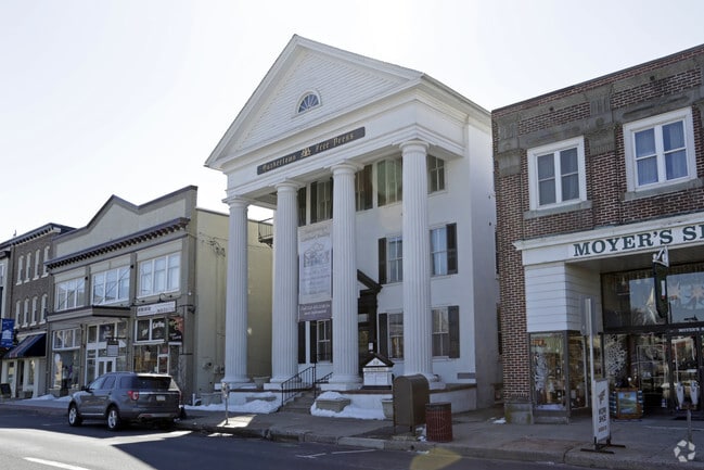
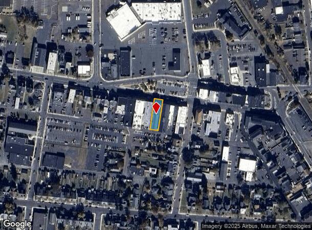
312 W Broad St, Quakertown, PA 18951

This Property Is For Sale
NEARBY LISTINGS FOR SALE OR LEASE
Property Detail
312 W Broad St
35-008-224
SS W BROAD ST 177 FT W 3R D ST 50X180
Vacantlandnec
Bucks
X
Pennsylvania
42017C0129J
0.21 AC
2024
Upper Bucks County
2025
Philadelphia
103102
Philadelphia-Camden-Wilmington, PA-NJ-DE-MD
9,650 SF
DEMOGRAPHICS near 312 W Broad St
1 Mile
3 Mile
5 Mile
2024 Total Population
9,843
27,999
41,834
2029 Population
9,844
27,872
41,548
Pop Growth 2024-2029
+ 0.01%
(0.45%)
(0.68%)
Average Age
40
42
43
2024 Total Households
3,897
10,716
15,929
HH Growth 2024-2029
(0.13%)
(0.59%)
(0.79%)
Median Household Inc
$72,569
$79,775
$87,087
Avg Household Size
2.40
2.50
2.50
2024 Avg HH Vehicles
2.00
2.00
2.00
Median Home Value
$251,752
$278,967
$316,525
Median Year Built
1959
1978
1978
Nearby Places
Map Layers
Map Styles
 Street
 Aerial
- Restaurants
- Banks
- Shops
- Fitness
- Groceries
PUBLIC TRANSPORTATION
AIRPORT
Lehigh Valley International
DRIVE
WALK
Distance
Lehigh Valley International
35 min
20.0 mi
Trenton Mercer
DRIVE
WALK
Distance
Trenton Mercer
61 min
36.0 mi
Freight Ports
Port of Philadelphia
DRIVE
WALK
Distance
Port of Philadelphia
63 min
38.8 mi
Nearby Properties
Address
Land Use
TOTAL SIZE
Lot Size
Zoning
Address
Land Use
TOTAL SIZE
Lot Size
Zoning
276,132 SF
61.72 AC
PC
Address
Land Use
TOTAL SIZE
Lot Size
Zoning
51,884 SF
40.42 AC
EXT
Address
Land Use
TOTAL SIZE
Lot Size
Zoning
203,923 SF
34.17 AC
HC
Address
Land Use
TOTAL SIZE
Lot Size
Zoning
157,360 SF
17.34 AC
SRC
Address
Land Use
TOTAL SIZE
Lot Size
Zoning
145,197 SF
17.11 AC
PC
Address
Land Use
TOTAL SIZE
Lot Size
Zoning
127,968 SF
15.38 AC
PC
Address
Land Use
TOTAL SIZE
Lot Size
Zoning
14,450 SF
7.16 AC
R4
Address
Land Use
TOTAL SIZE
Lot Size
Zoning
86,827 SF
11.84 AC
PC
Address
Land Use
TOTAL SIZE
Lot Size
Zoning
362,576 SF
25.24 AC
PI
Address
Land Use
TOTAL SIZE
Lot Size
Zoning
1 SF
15.66 AC
PC
Address
Land Use
TOTAL SIZE
Lot Size
Zoning
215,368 SF
24.49 AC
SRM
Address
Land Use
TOTAL SIZE
Lot Size
Zoning
208,937 SF
20.07 AC
PC
Address
Land Use
TOTAL SIZE
Lot Size
Zoning
145,800 SF
11.66 AC
P1
Address
Land Use
TOTAL SIZE
Lot Size
Zoning
67,443 SF
1.97 AC
NC
Address
Land Use
TOTAL SIZE
Lot Size
Zoning
58,391 SF
9.45 AC
PC
Address
Land Use
TOTAL SIZE
Lot Size
Zoning
7.98 AC
PI
Address
Land Use
TOTAL SIZE
Lot Size
Zoning
186,547 SF
18.74 AC
PI
Address
Land Use
TOTAL SIZE
Lot Size
Zoning
1,200 SF
17.50 AC
PI
Address
Land Use
TOTAL SIZE
Lot Size
Zoning
114,400 SF
9.96 AC
P1
Address
Land Use
TOTAL SIZE
Lot Size
Zoning
71,000 SF
5.90 AC
EXT
Address
Land Use
TOTAL SIZE
Lot Size
Zoning
117,432 SF
11.92 AC
PI
Address
Land Use
TOTAL SIZE
Lot Size
Zoning
36,450 SF
3.09 AC
HC
Address
Land Use
TOTAL SIZE
Lot Size
Zoning
125,000 SF
19.58 AC
PI
Address
Land Use
TOTAL SIZE
Lot Size
Zoning
12,734 SF
4.68 AC
HC
Address
Land Use
TOTAL SIZE
Lot Size
Zoning
34,206 SF
11.49 AC
PC
Address
Land Use
TOTAL SIZE
Lot Size
Zoning
48,457 SF
2.73 AC
PC
Address
Land Use
TOTAL SIZE
Lot Size
Zoning
22,950 SF
1.97 AC
HR
Address
Land Use
TOTAL SIZE
Lot Size
Zoning
83,508 SF
7.91 AC
PI
Address
Land Use
TOTAL SIZE
Lot Size
Zoning
170,655 SF
25.75 AC
PI
Address
Land Use
TOTAL SIZE
Lot Size
Zoning
4.22 AC
R4
The World's #1 Commercial Real Estate Marketplace
Connect with us
© 2025 CoStar Group
The information above has been obtained from sources believed reliable. While we do not doubt its accuracy we have not verified it and make no guarantee, warranty or representation about it. It is your responsibility to independently confirm its accuracy and completeness. Any projections, opinions, assumptions, or estimates used are for example only and do not represent the current or future performance of the property. The value of this transaction to you depends on tax and other factors which should be evaluated by your tax, financial, and legal advisors. You and your advisors should conduct a careful, independent investigation of the property to determine to your satisfaction the suitability of the property for your needs.