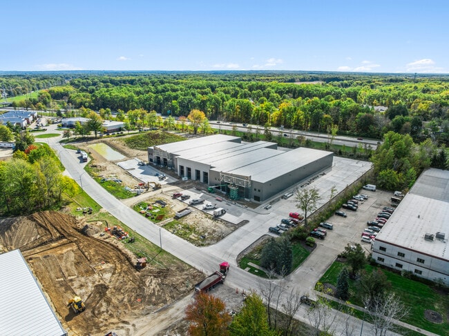
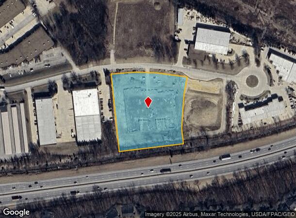
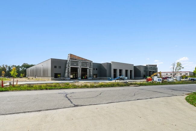
Property Record
31369 N Industrial Pkwy, North Olmsted, OH 44070
Current Lease Availabilities
NEARBY LISTINGS FOR SALE OR LEASE
Property Detail
31369 N Industrial Pkwy
Cleveland-Elyria, OH
Sunrise Dev Co Harlan Sherman
234-11-141
1 16 0006
Industrialacreage
Cuyahoga
X
Ohio
39035C0139E
6
2024
4.71 AC
2024
N Olmsted/Fairview
174203
Cleveland
DEMOGRAPHICS near 31369 N Industrial Pkwy
1 Mile
3 Mile
5 Mile
2024 Total Population
4,488
50,137
118,725
2029 Population
4,415
50,084
118,787
Pop Growth 2024-2029
(1.63%)
(0.11%)
+ 0.05%
Average Age
47
44
43
2024 Total Households
1,871
20,458
47,857
HH Growth 2024-2029
(1.82%)
(0.15%)
(0.15%)
Median Household Inc
$85,247
$83,009
$88,041
Avg Household Size
2.30
2.40
2.40
2024 Avg HH Vehicles
2.00
2.00
2.00
Median Home Value
$204,290
$203,243
$231,381
Median Year Built
1977
1979
1981
Nearby Places
- Restaurants
- Banks
- Shops
- Fitness
- Groceries
PUBLIC TRANSPORTATION
AIRPORT
Cleveland-Hopkins International
DRIVE
WALK
Distance
Cleveland-Hopkins International
17 min
7.6 mi
Freight Ports
Port of Toledo
DRIVE
WALK
Distance
Port of Toledo
113 min
95.3 mi
Nearby Properties
Address
Land Use
TOTAL SIZE
Lot Size
Zoning
Address
Land Use
TOTAL SIZE
Lot Size
Zoning
327,732 SF
57.22 AC
1F
Address
Land Use
TOTAL SIZE
Lot Size
Zoning
278,056 SF
42.71 AC
R-40
Address
Land Use
TOTAL SIZE
Lot Size
Zoning
195,990 SF
46.88 AC
RMF-A
Address
Land Use
TOTAL SIZE
Lot Size
Zoning
176,857 SF
8.62 AC
B-2
Address
Land Use
TOTAL SIZE
Lot Size
Zoning
46,133 SF
35.03 AC
RMF-A
Address
Land Use
TOTAL SIZE
Lot Size
Zoning
209,822 SF
26.92 AC
R-40
Address
Land Use
TOTAL SIZE
Lot Size
Zoning
50,668 SF
9.04 AC
Address
Land Use
TOTAL SIZE
Lot Size
Zoning
130,030 SF
5.69 AC
RMF-A
Address
Land Use
TOTAL SIZE
Lot Size
Zoning
128,416 SF
13.42 AC
R-40
Address
Land Use
TOTAL SIZE
Lot Size
Zoning
174,721 SF
15.60 AC
Address
Land Use
TOTAL SIZE
Lot Size
Zoning
179,879 SF
5.34 AC
RMF-A
Address
Land Use
TOTAL SIZE
Lot Size
Zoning
43,950 SF
9.40 AC
Address
Land Use
TOTAL SIZE
Lot Size
Zoning
39,418 SF
6.05 AC
Address
Land Use
TOTAL SIZE
Lot Size
Zoning
57,126 SF
11.74 AC
Address
Land Use
TOTAL SIZE
Lot Size
Zoning
30,264 SF
6.50 AC
CRG
Address
Land Use
TOTAL SIZE
Lot Size
Zoning
18,697 SF
4.47 AC
Address
Land Use
TOTAL SIZE
Lot Size
Zoning
73,673 SF
6.80 AC
SR
Address
Land Use
TOTAL SIZE
Lot Size
Zoning
27,445 SF
2 AC
Address
Land Use
TOTAL SIZE
Lot Size
Zoning
88,501 SF
8.12 AC
F-1F80
Address
Land Use
TOTAL SIZE
Lot Size
Zoning
50,064 SF
15.73 AC
Address
Land Use
TOTAL SIZE
Lot Size
Zoning
54,847 SF
6.99 AC
CRG
Address
Land Use
TOTAL SIZE
Lot Size
Zoning
99,422 SF
13.77 AC
Address
Land Use
TOTAL SIZE
Lot Size
Zoning
37,746 SF
9.42 AC
Address
Land Use
TOTAL SIZE
Lot Size
Zoning
130,800 SF
38.73 AC
RMF-T
Address
Land Use
TOTAL SIZE
Lot Size
Zoning
42,487 SF
33.33 AC
Address
Land Use
TOTAL SIZE
Lot Size
Zoning
49,926 SF
18.42 AC
Address
Land Use
TOTAL SIZE
Lot Size
Zoning
29,024 SF
7.29 AC
Address
Land Use
TOTAL SIZE
Lot Size
Zoning
55,496 SF
6.29 AC
CRG
Address
Land Use
TOTAL SIZE
Lot Size
Zoning
93,980 SF
12.48 AC
Address
Land Use
TOTAL SIZE
Lot Size
Zoning
121,778 SF
23.40 AC
D-3
The World's #1 Commercial Real Estate Marketplace
Connect with us
© 2025 CoStar Group
The information above has been obtained from sources believed reliable. While we do not doubt its accuracy we have not verified it and make no guarantee, warranty or representation about it. It is your responsibility to independently confirm its accuracy and completeness. Any projections, opinions, assumptions, or estimates used are for example only and do not represent the current or future performance of the property. The value of this transaction to you depends on tax and other factors which should be evaluated by your tax, financial, and legal advisors. You and your advisors should conduct a careful, independent investigation of the property to determine to your satisfaction the suitability of the property for your needs.