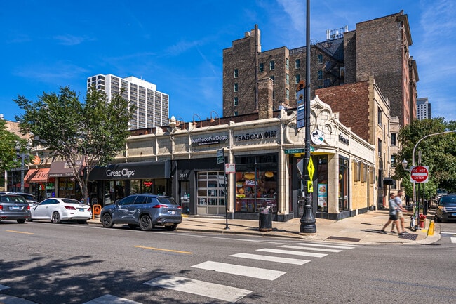
Property Record
3139 N Broadway St, Chicago, IL 60657

Property Detail
3139 N Broadway St
Commercialbuilding
COOK
B3-2
Illinois
B and X Area of moderate flood hazard, usually the area between the limits of the 100-year and 500-year floods.
0.15 AC
2023
Lincoln Park
2025
Chicago
063200
Chicago-Naperville-Elgin, IL-IN
5,815 SF
14-28-102-013-0000
NEARBY LISTINGS FOR SALE OR LEASE
DEMOGRAPHICS near 3139 N Broadway St
1 mile
3 mile
5 mile
2025 Total Population
92,790
417,379
984,106
2030 Population
93,681
420,657
985,943
Pop Growth 2025-2030
+ 0.96%
+ 0.79%
+ 0.19%
Average Age
36
37
37
2025 Total Households
54,907
221,415
484,205
HH Growth 2025-2030
+ 0.81%
+ 0.69%
+ 0.33%
Median Household Inc
$100,097
$108,756
$101,276
Avg Household Size
1.70
1.80
1.90
2025 Avg HH Vehicles
1.00
1.00
1.00
Median Home Value
$487,343
$573,723
$482,037
Median Year Built
1963
1963
1961
Nearby Places
Map Layers
Map Styles
 Street
 Aerial
Layers
 Traffic
 Biking
Places
Listings with unknown addresses are not visible on the map
- Restaurants
- Banks
- Shops
- Fitness
- Groceries
PUBLIC TRANSPORTATION
TRANSIT/SUBWAY
Belmont Station (Brown, Purple, Red Lines) (Brown Line - Chicago Transit Authority "L" Trains (The "L"), Purple Line - Chicago Transit Authority "L" Trains (The "L"), Red Line - Chicago Transit Authority "L" Trains (The "L"))
Drive
Walk
Distance
Belmont Station (Brown, Purple, Red Lines) (Brown Line - Chicago Transit Authority "L" Trains (The "L"), Purple Line - Chicago Transit Authority "L" Trains (The "L"), Red Line - Chicago Transit Authority "L" Trains (The "L"))
1 min
10 min
0.5 mi
Wellington Station (Brown Line - Chicago Transit Authority "L" Trains (The "L"), Purple Line - Chicago Transit Authority "L" Trains (The "L"))
Drive
Walk
Distance
Wellington Station (Brown Line - Chicago Transit Authority "L" Trains (The "L"), Purple Line - Chicago Transit Authority "L" Trains (The "L"))
2 min
13 min
0.7 mi
Diversey Station (Brown Line - Chicago Transit Authority "L" Trains (The "L"), Purple Line - Chicago Transit Authority "L" Trains (The "L"))
Drive
Walk
Distance
Diversey Station (Brown Line - Chicago Transit Authority "L" Trains (The "L"), Purple Line - Chicago Transit Authority "L" Trains (The "L"))
2 min
17 min
0.9 mi
Addison Station (Red Line) (Red Line - Chicago Transit Authority "L" Trains (The "L"))
Drive
Walk
Distance
Addison Station (Red Line) (Red Line - Chicago Transit Authority "L" Trains (The "L"))
2 min
18 min
0.9 mi
COMMUTER RAIL
Clybourn Station (Union Pacific North Line - Northeast Illinois Regional Commuter Railroad (Metra), Union Pacific Northwest Line - Northeast Illinois Regional Commuter Railroad (Metra))
Drive
Walk
Distance
Clybourn Station (Union Pacific North Line - Northeast Illinois Regional Commuter Railroad (Metra), Union Pacific Northwest Line - Northeast Illinois Regional Commuter Railroad (Metra))
6 min
2.8 mi
Ravenswood Station (Union Pacific North Line - Northeast Illinois Regional Commuter Railroad (Metra))
Drive
Walk
Distance
Ravenswood Station (Union Pacific North Line - Northeast Illinois Regional Commuter Railroad (Metra))
7 min
3.3 mi
AIRPORT
Chicago Midway International
Drive
Walk
Distance
Chicago Midway International
30 min
14.7 mi
Chicago O'Hare International
Drive
Walk
Distance
Chicago O'Hare International
48 min
18.4 mi
SALE & LEASE HISTORY
LISTING DATE
SALE/LEASE

Sep 23, 2025
For Sale
Nearby Properties
Address
Land Use
TOTAL SIZE
Lot Size
Zoning
Address
Land Use
TOTAL SIZE
Lot Size
Zoning
831,084 SF
2.05 AC
PD 316
Address
Land Use
TOTAL SIZE
Lot Size
Zoning
1,857,394 SF
3.13 AC
PD 447
Address
Land Use
TOTAL SIZE
Lot Size
Zoning
1.09 AC
B1-3
Address
Land Use
TOTAL SIZE
Lot Size
Zoning
491,382 SF
2.05 AC
PD 316
Address
Land Use
TOTAL SIZE
Lot Size
Zoning
549,130 SF
1.45 AC
DX-12
Address
Land Use
TOTAL SIZE
Lot Size
Zoning
1,412,950 SF
1.03 AC
DX-12
Address
Land Use
TOTAL SIZE
Lot Size
Zoning
1.36 AC
DX-12
Address
Land Use
TOTAL SIZE
Lot Size
Zoning
0.34 AC
PD 967
Address
Land Use
TOTAL SIZE
Lot Size
Zoning
266,248 SF
Address
Land Use
TOTAL SIZE
Lot Size
Zoning
134,668 SF
0.28 AC
PD 1291
Address
Land Use
TOTAL SIZE
Lot Size
Zoning
393,325 SF
Address
Land Use
TOTAL SIZE
Lot Size
Zoning
Address
Land Use
TOTAL SIZE
Lot Size
Zoning
222,240 SF
2.45 AC
PD 1439
Address
Land Use
TOTAL SIZE
Lot Size
Zoning
Address
Land Use
TOTAL SIZE
Lot Size
Zoning
602,197 SF
Address
Land Use
TOTAL SIZE
Lot Size
Zoning
623,912 SF
Address
Land Use
TOTAL SIZE
Lot Size
Zoning
61,300 SF
0.30 AC
B3-5
Address
Land Use
TOTAL SIZE
Lot Size
Zoning
494,076 SF
0.37 AC
DX-12
Address
Land Use
TOTAL SIZE
Lot Size
Zoning
96,266 SF
0.47 AC
PD 509
Address
Land Use
TOTAL SIZE
Lot Size
Zoning
652,620 SF
Address
Land Use
TOTAL SIZE
Lot Size
Zoning
531,961 SF
1.24 AC
PD 1262
Address
Land Use
TOTAL SIZE
Lot Size
Zoning
1,426,524 SF
2.15 AC
RM-6.5
Address
Land Use
TOTAL SIZE
Lot Size
Zoning
448,000 SF
0.47 AC
PD 1213
Address
Land Use
TOTAL SIZE
Lot Size
Zoning
374,400 SF
1.04 AC
PD 316
Address
Land Use
TOTAL SIZE
Lot Size
Zoning
2.64 AC
PD 447
Address
Land Use
TOTAL SIZE
Lot Size
Zoning
0.96 AC
PD 958
Address
Land Use
TOTAL SIZE
Lot Size
Zoning
24,296 SF
0.25 AC
RM-5
Address
Land Use
TOTAL SIZE
Lot Size
Zoning
0.25 AC
PD 133
Address
Land Use
TOTAL SIZE
Lot Size
Zoning
311,612 SF
2.40 AC
PD 1096
Address
Land Use
TOTAL SIZE
Lot Size
Zoning
0.11 AC
DX-12
The World's #1 Commercial Real Estate Marketplace
Connect with us
© 2026 CoStar Group
The information above has been obtained from sources believed reliable. While we do not doubt its accuracy we have not verified it and make no guarantee, warranty or representation about it. It is your responsibility to independently confirm its accuracy and completeness. Any projections, opinions, assumptions, or estimates used are for example only and do not represent the current or future performance of the property. The value of this transaction to you depends on tax and other factors which should be evaluated by your tax, financial, and legal advisors. You and your advisors should conduct a careful, independent investigation of the property to determine to your satisfaction the suitability of the property for your needs.