Property Record
315 Johnstown Rd, Elkton, MD 21921
NEARBY LISTINGS FOR SALE OR LEASE
-
-
View all Elkton listings for sale on LoopNet.com
Property Detail
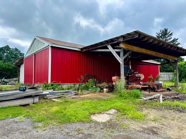
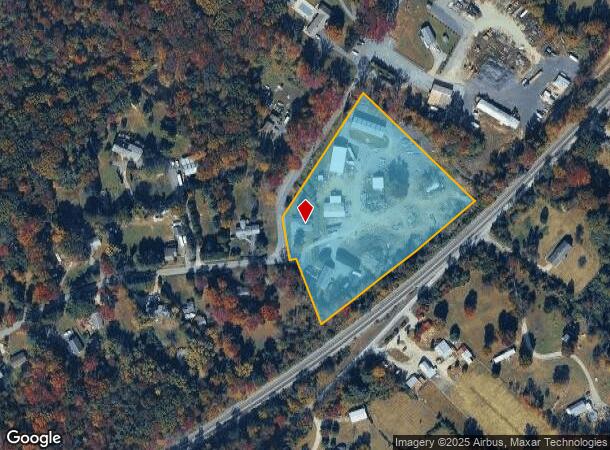
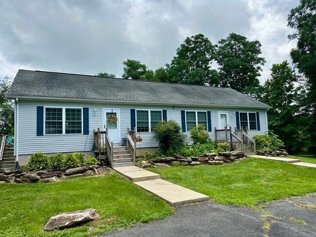
315 Johnstown Rd
03-010627
4.769 ACRES 315 JOHNSTOWN ROAD N OF ELKTON
Multifamilydwelling
Cecil
X
Maryland
24015C0089D
4.76 AC
2025
Cecil County
2025
Baltimore
030501
Philadelphia-Camden-Wilmington, PA-NJ-DE-MD
1,650 SF
DEMOGRAPHICS near 315 Johnstown Rd
1 mile
3 mile
5 mile
2024 Total Population
1,298
18,584
71,372
2029 Population
1,366
19,591
75,378
Pop Growth 2024-2029
+ 5.24%
+ 5.42%
+ 5.61%
Average Age
41
39
39
2024 Total Households
453
7,220
26,434
HH Growth 2024-2029
+ 5.30%
+ 5.50%
+ 5.88%
Median Household Inc
$132,670
$79,099
$85,699
Avg Household Size
2.80
2.50
2.50
2024 Avg HH Vehicles
2.00
2.00
2.00
Median Home Value
$337,727
$301,988
$345,613
Median Year Built
1985
1991
1983
Nearby Places
Map Layers
Map Styles
 Street
 Aerial
Transit
 Traffic
 Biking
Places
Listings with unknown addresses are not visible on the map
- Restaurants
- Banks
- Shops
- Fitness
- Groceries
SALE & LEASE HISTORY
LISTING DATE
SALE/LEASE

Jul 21, 2025
For Sale
Nearby Properties
Address
Land Use
TOTAL SIZE
Lot Size
Zoning
Address
Land Use
TOTAL SIZE
Lot Size
Zoning
756,122 SF
70.18 AC
M1
Address
Land Use
TOTAL SIZE
Lot Size
Zoning
142,774 SF
131.33 AC
M1
Address
Land Use
TOTAL SIZE
Lot Size
Zoning
70,092 SF
41.59 AC
UR
Address
Land Use
TOTAL SIZE
Lot Size
Zoning
19.26 AC
RM
Address
Land Use
TOTAL SIZE
Lot Size
Zoning
383,319 SF
234.70 AC
I
Address
Land Use
TOTAL SIZE
Lot Size
Zoning
64,148 SF
31.54 AC
M1
Address
Land Use
TOTAL SIZE
Lot Size
Zoning
20,973 SF
75.14 AC
M1
Address
Land Use
TOTAL SIZE
Lot Size
Zoning
81,072 SF
12.86 AC
RM
Address
Land Use
TOTAL SIZE
Lot Size
Zoning
41,000 SF
32.49 AC
M1
Address
Land Use
TOTAL SIZE
Lot Size
Zoning
131,806 SF
21.97 AC
BI
Address
Land Use
TOTAL SIZE
Lot Size
Zoning
31,350 SF
8.89 AC
R2
Address
Land Use
TOTAL SIZE
Lot Size
Zoning
17.50 AC
R3
Address
Land Use
TOTAL SIZE
Lot Size
Zoning
2,189 SF
37.37 AC
BI
Address
Land Use
TOTAL SIZE
Lot Size
Zoning
159,038 SF
22.52 AC
R3
Address
Land Use
TOTAL SIZE
Lot Size
Zoning
15,900 SF
230.94 AC
M2
Address
Land Use
TOTAL SIZE
Lot Size
Zoning
40,074 SF
90.98 AC
M1
Address
Land Use
TOTAL SIZE
Lot Size
Zoning
46,754 SF
20.78 AC
M1
Address
Land Use
TOTAL SIZE
Lot Size
Zoning
35,947 SF
50 AC
NAR
Address
Land Use
TOTAL SIZE
Lot Size
Zoning
64,800 SF
14.01 AC
C3
Address
Land Use
TOTAL SIZE
Lot Size
Zoning
32,997 SF
6.77 AC
R3 C2
Address
Land Use
TOTAL SIZE
Lot Size
Zoning
9,930 SF
351.26 AC
SPLIT
Address
Land Use
TOTAL SIZE
Lot Size
Zoning
14,136 SF
9.81 AC
UR
Address
Land Use
TOTAL SIZE
Lot Size
Zoning
35,617 SF
4.15 AC
C2
Address
Land Use
TOTAL SIZE
Lot Size
Zoning
82,079 SF
13.60 AC
R2
Address
Land Use
TOTAL SIZE
Lot Size
Zoning
8,864 SF
28.61 AC
BI
Address
Land Use
TOTAL SIZE
Lot Size
Zoning
15,215 SF
20.22 AC
18RH
Address
Land Use
TOTAL SIZE
Lot Size
Zoning
163,650 SF
2.98 AC
C1
Address
Land Use
TOTAL SIZE
Lot Size
Zoning
306,221 SF
17.44 AC
18OFD
Address
Land Use
TOTAL SIZE
Lot Size
Zoning
51,609 SF
9.84 AC
UR
Address
Land Use
TOTAL SIZE
Lot Size
Zoning
217,027 SF
12.98 AC
18MOR
The World's #1 Commercial Real Estate Marketplace
Connect with us
© 2026 CoStar Group
The information above has been obtained from sources believed reliable. While we do not doubt its accuracy we have not verified it and make no guarantee, warranty or representation about it. It is your responsibility to independently confirm its accuracy and completeness. Any projections, opinions, assumptions, or estimates used are for example only and do not represent the current or future performance of the property. The value of this transaction to you depends on tax and other factors which should be evaluated by your tax, financial, and legal advisors. You and your advisors should conduct a careful, independent investigation of the property to determine to your satisfaction the suitability of the property for your needs.