Property Record
3157 Richfield Rd, Flint, MI 48506


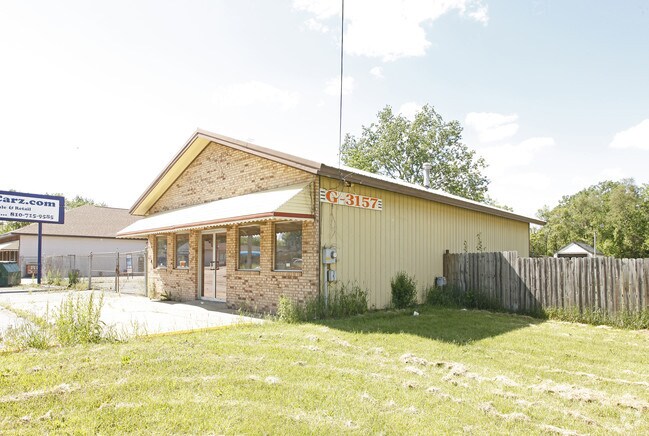
Property Detail
3157 Richfield Rd
11-33-300-057
A PARCEL OF LAND BEG AT A POINT IN CENTER LINE OF RICHFIELD RD N 89 DEG 38 MIN E 250 FT FROM ITS INTERSECTION WITH CENTER
Commercialnec
Genesee
C-2 HWY CO
Michigan
B and X Area of moderate flood hazard, usually the area between the limits of the 100-year and 500-year floods.
0.80 AC
2025
Flint
2025
Detroit
012006
Flint, MI
1,500 SF
NEARBY LISTINGS FOR SALE OR LEASE
DEMOGRAPHICS near 3157 Richfield Rd
1 mile
3 mile
5 mile
2025 Total Population
7,866
43,472
131,179
2030 Population
7,942
44,085
133,270
Pop Growth 2025-2030
+ 0.97%
+ 1.41%
+ 1.59%
Average Age
39
40
40
2025 Total Households
3,229
18,373
53,894
HH Growth 2025-2030
+ 0.84%
+ 1.28%
+ 1.60%
Median Household Inc
$35,198
$37,859
$40,143
Avg Household Size
2.30
2.30
2.30
2025 Avg HH Vehicles
1.00
1.00
1.00
Median Home Value
$66,007
$87,332
$84,865
Median Year Built
1957
1956
1958
Nearby Places
Map Layers
Map Styles
 Street
 Aerial
Layers
 Traffic
 Biking
Places
Listings with unknown addresses are not visible on the map
- Restaurants
- Banks
- Shops
- Fitness
- Groceries
PUBLIC TRANSPORTATION
COMMUTER RAIL
Drive
Walk
Distance
7 min
3.1 mi
AIRPORT
Bishop International
Drive
Walk
Distance
Bishop International
25 min
12.7 mi
Nearby Properties
Address
Land Use
TOTAL SIZE
Lot Size
Zoning
Address
Land Use
TOTAL SIZE
Lot Size
Zoning
MOBILE
Address
Land Use
TOTAL SIZE
Lot Size
Zoning
290,267 SF
79 AC
PC
Address
Land Use
TOTAL SIZE
Lot Size
Zoning
46,808 SF
32.06 AC
I-2 HVY IN
Address
Land Use
TOTAL SIZE
Lot Size
Zoning
354,079 SF
48.41 AC
C-4
Address
Land Use
TOTAL SIZE
Lot Size
Zoning
371,636 SF
12.50 AC
M-1
Address
Land Use
TOTAL SIZE
Lot Size
Zoning
329,849 SF
21.20 AC
CE
Address
Land Use
TOTAL SIZE
Lot Size
Zoning
111,882 SF
5.36 AC
C-4
Address
Land Use
TOTAL SIZE
Lot Size
Zoning
419,038 SF
57.18 AC
M-2
Address
Land Use
TOTAL SIZE
Lot Size
Zoning
156,250 SF
Address
Land Use
TOTAL SIZE
Lot Size
Zoning
136,506 SF
16.54 AC
C-4
Address
Land Use
TOTAL SIZE
Lot Size
Zoning
114,888 SF
11.86 AC
I-2 HVY IN
Address
Land Use
TOTAL SIZE
Lot Size
Zoning
182,408 SF
Address
Land Use
TOTAL SIZE
Lot Size
Zoning
Address
Land Use
TOTAL SIZE
Lot Size
Zoning
122,240 SF
3.42 AC
TN-2
Address
Land Use
TOTAL SIZE
Lot Size
Zoning
3.45 AC
MR-3
Address
Land Use
TOTAL SIZE
Lot Size
Zoning
218,229 SF
37.64 AC
CE
Address
Land Use
TOTAL SIZE
Lot Size
Zoning
149,136 SF
9.35 AC
CE
Address
Land Use
TOTAL SIZE
Lot Size
Zoning
Address
Land Use
TOTAL SIZE
Lot Size
Zoning
66,800 SF
1.50 AC
MR-3
Address
Land Use
TOTAL SIZE
Lot Size
Zoning
192,900 SF
6.50 AC
CE
Address
Land Use
TOTAL SIZE
Lot Size
Zoning
118,210 SF
6.60 AC
CE
Address
Land Use
TOTAL SIZE
Lot Size
Zoning
173,312 SF
23.49 AC
CE
Address
Land Use
TOTAL SIZE
Lot Size
Zoning
61,800 SF
1.87 AC
CC
Address
Land Use
TOTAL SIZE
Lot Size
Zoning
72,720 SF
6.41 AC
C-2
Address
Land Use
TOTAL SIZE
Lot Size
Zoning
4.25 AC
MR-3
Address
Land Use
TOTAL SIZE
Lot Size
Zoning
726 SF
10.40 AC
R-4 MANUF
Address
Land Use
TOTAL SIZE
Lot Size
Zoning
58,197 SF
11.90 AC
C-2
Address
Land Use
TOTAL SIZE
Lot Size
Zoning
43,751 SF
3.14 AC
TN-2
Address
Land Use
TOTAL SIZE
Lot Size
Zoning
48,411 SF
16.05 AC
CE
Address
Land Use
TOTAL SIZE
Lot Size
Zoning
38,364 SF
1.90 AC
CE
The World's #1 Commercial Real Estate Marketplace
Connect with us
© 2026 CoStar Group
The information above has been obtained from sources believed reliable. While we do not doubt its accuracy we have not verified it and make no guarantee, warranty or representation about it. It is your responsibility to independently confirm its accuracy and completeness. Any projections, opinions, assumptions, or estimates used are for example only and do not represent the current or future performance of the property. The value of this transaction to you depends on tax and other factors which should be evaluated by your tax, financial, and legal advisors. You and your advisors should conduct a careful, independent investigation of the property to determine to your satisfaction the suitability of the property for your needs.