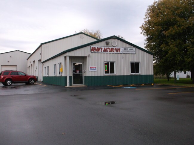
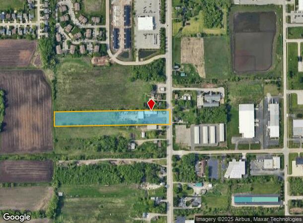
Property Record
3185 Jackson St, Oshkosh, WI 54901

NEARBY LISTINGS FOR SALE OR LEASE
-
-
View all Oshkosh listings for sale on LoopNet.com
Property Detail
3185 Jackson St
Oshkosh-Neenah, WI
Town Of Oshkosh
018-0059
S 5 A OF N1/2 OF NE SE 5.00 A.
Commercialnec
Winnebago
X
Wisconsin
55139C0220E
5 AC
2024
Appleton/Oshkosh
2024
Other Market Areas
001700
DEMOGRAPHICS near 3185 Jackson St
1 mile
3 mile
5 mile
2024 Total Population
5,285
39,454
73,444
2029 Population
5,240
39,511
73,715
Pop Growth 2024-2029
(0.85%)
+ 0.14%
+ 0.37%
Average Age
41
38
39
2024 Total Households
1,450
15,385
30,428
HH Growth 2024-2029
0.00%
+ 0.55%
+ 0.60%
Median Household Inc
$59,965
$54,888
$59,228
Avg Household Size
2.30
2.10
2.20
2024 Avg HH Vehicles
2.00
2.00
2.00
Median Home Value
$171,898
$161,738
$171,050
Median Year Built
1986
1966
1971
Nearby Places
Map Layers
Map Styles
 Street
 Aerial
Transit
 Traffic
 Biking
Places
Listings with unknown addresses are not visible on the map
- Restaurants
- Banks
- Shops
- Fitness
- Groceries
PUBLIC TRANSPORTATION
AIRPORT
Appleton International
Drive
Walk
Distance
Appleton International
24 min
17.6 mi
Freight Ports
Port Milwaukee
Drive
Walk
Distance
Port Milwaukee
109 min
92.5 mi
SALE & LEASE HISTORY
LISTING DATE
SALE/LEASE

Nov 25, 2019
For Sale
Jan 03, 2020
For Sale
Nearby Properties
Address
Land Use
TOTAL SIZE
Lot Size
Zoning
Address
Land Use
TOTAL SIZE
Lot Size
Zoning
32.81 AC
CBPPD
Address
Land Use
TOTAL SIZE
Lot Size
Zoning
552,602 SF
7.28 AC
M3
Address
Land Use
TOTAL SIZE
Lot Size
Zoning
485,007 SF
41.76 AC
M3
Address
Land Use
TOTAL SIZE
Lot Size
Zoning
195,847 SF
4.66 AC
UMU-PD
Address
Land Use
TOTAL SIZE
Lot Size
Zoning
2.29 AC
RMUPDRFO
Address
Land Use
TOTAL SIZE
Lot Size
Zoning
140,184 SF
17.35 AC
MR-20-PD
Address
Land Use
TOTAL SIZE
Lot Size
Zoning
70,672 SF
4.97 AC
Address
Land Use
TOTAL SIZE
Lot Size
Zoning
70,335 SF
16 AC
HI
Address
Land Use
TOTAL SIZE
Lot Size
Zoning
2.40 AC
CBP-PD
Address
Land Use
TOTAL SIZE
Lot Size
Zoning
152,505 SF
6.54 AC
MR-20-RFO
Address
Land Use
TOTAL SIZE
Lot Size
Zoning
84,363 SF
10.97 AC
C-2PD
Address
Land Use
TOTAL SIZE
Lot Size
Zoning
175,906 SF
11.60 AC
MR-20
Address
Land Use
TOTAL SIZE
Lot Size
Zoning
1.78 AC
C3
Address
Land Use
TOTAL SIZE
Lot Size
Zoning
140,296 SF
13.58 AC
C-2
Address
Land Use
TOTAL SIZE
Lot Size
Zoning
4.76 AC
C2
Address
Land Use
TOTAL SIZE
Lot Size
Zoning
106,340 SF
5.37 AC
MR-20
Address
Land Use
TOTAL SIZE
Lot Size
Zoning
366,482 SF
35.73 AC
M2
Address
Land Use
TOTAL SIZE
Lot Size
Zoning
4.52 AC
SMU-PD
Address
Land Use
TOTAL SIZE
Lot Size
Zoning
96,928 SF
6.94 AC
MR-12
Address
Land Use
TOTAL SIZE
Lot Size
Zoning
100,912 SF
5.50 AC
MR-20
Address
Land Use
TOTAL SIZE
Lot Size
Zoning
179,700 SF
10.06 AC
M3
Address
Land Use
TOTAL SIZE
Lot Size
Zoning
37.96 AC
Address
Land Use
TOTAL SIZE
Lot Size
Zoning
71,538 SF
7.89 AC
I-PD
Address
Land Use
TOTAL SIZE
Lot Size
Zoning
76,815 SF
12.27 AC
C2
Address
Land Use
TOTAL SIZE
Lot Size
Zoning
621,225 SF
31.97 AC
M2
Address
Land Use
TOTAL SIZE
Lot Size
Zoning
135,562 SF
9.40 AC
MR-20-PD
Address
Land Use
TOTAL SIZE
Lot Size
Zoning
71,610 SF
4.30 AC
MR-20
Address
Land Use
TOTAL SIZE
Lot Size
Zoning
24,751 SF
7.75 AC
C2
Address
Land Use
TOTAL SIZE
Lot Size
Zoning
62,266 SF
14.54 AC
HI
Address
Land Use
TOTAL SIZE
Lot Size
Zoning
14.92 AC
M1
The World's #1 Commercial Real Estate Marketplace
Connect with us
© 2026 CoStar Group
The information above has been obtained from sources believed reliable. While we do not doubt its accuracy we have not verified it and make no guarantee, warranty or representation about it. It is your responsibility to independently confirm its accuracy and completeness. Any projections, opinions, assumptions, or estimates used are for example only and do not represent the current or future performance of the property. The value of this transaction to you depends on tax and other factors which should be evaluated by your tax, financial, and legal advisors. You and your advisors should conduct a careful, independent investigation of the property to determine to your satisfaction the suitability of the property for your needs.