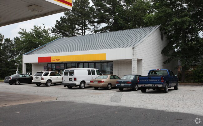
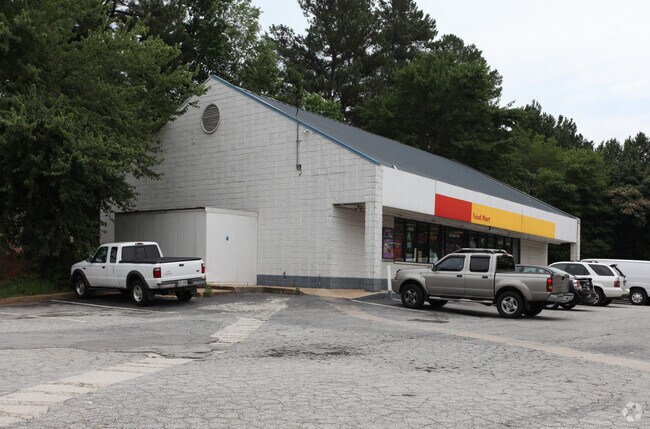
Property Record
32 Killian Hill Rd Sw, Lilburn, GA 30047

Property Detail
32 Killian Hill Rd Sw
6-133-175
KILLIAN HILL RD
Supermarket
Gwinnett
C2
Georgia
B and X Area of moderate flood hazard, usually the area between the limits of the 100-year and 500-year floods.
1.30 AC
2025
Lilburn/Snellville
2025
Atlanta
050461
Atlanta-Sandy Springs-Roswell, GA
3,082 SF
NEARBY LISTINGS FOR SALE OR LEASE
DEMOGRAPHICS near 32 Killian Hill Rd Sw
1 mile
3 mile
5 mile
2025 Total Population
5,883
86,766
247,211
2030 Population
6,150
89,967
256,275
Pop Growth 2025-2030
+ 4.54%
+ 3.69%
+ 3.67%
Average Age
39
37
37
2025 Total Households
1,934
27,206
82,633
HH Growth 2025-2030
+ 4.45%
+ 3.71%
+ 3.72%
Median Household Inc
$65,400
$72,987
$70,030
Avg Household Size
3.10
3.10
2.90
2025 Avg HH Vehicles
2.00
2.00
2.00
Median Home Value
$376,679
$362,254
$360,841
Median Year Built
1982
1986
1988
Nearby Places
Map Layers
Map Styles
 Street
 Aerial
Transit
 Traffic
 Biking
Places
Listings with unknown addresses are not visible on the map
- Restaurants
- Banks
- Shops
- Fitness
- Groceries
PUBLIC TRANSPORTATION
AIRPORT
Hartsfield - Jackson Atlanta International
Drive
Walk
Distance
Hartsfield - Jackson Atlanta International
46 min
31.5 mi
Freight Ports
Georgia Ports - Savannah
Drive
Walk
Distance
Georgia Ports - Savannah
299 min
263.4 mi
Nearby Properties
Address
Land Use
TOTAL SIZE
Lot Size
Zoning
Address
Land Use
TOTAL SIZE
Lot Size
Zoning
338,670 SF
28.61 AC
RM
Address
Land Use
TOTAL SIZE
Lot Size
Zoning
464,756 SF
33.96 AC
RM13
Address
Land Use
TOTAL SIZE
Lot Size
Zoning
483,912 SF
43.10 AC
OI
Address
Land Use
TOTAL SIZE
Lot Size
Zoning
470,856 SF
34.99 AC
RM13
Address
Land Use
TOTAL SIZE
Lot Size
Zoning
313,246 SF
17.15 AC
RM13
Address
Land Use
TOTAL SIZE
Lot Size
Zoning
413,878 SF
29.13 AC
CB
Address
Land Use
TOTAL SIZE
Lot Size
Zoning
455,471 SF
48.23 AC
R75
Address
Land Use
TOTAL SIZE
Lot Size
Zoning
285,384 SF
21.32 AC
RM
Address
Land Use
TOTAL SIZE
Lot Size
Zoning
371,383 SF
29.56 AC
RM13
Address
Land Use
TOTAL SIZE
Lot Size
Zoning
287,502 SF
43.15 AC
R1
Address
Land Use
TOTAL SIZE
Lot Size
Zoning
526,306 SF
77.45 AC
R100
Address
Land Use
TOTAL SIZE
Lot Size
Zoning
283,958 SF
23.75 AC
RM13
Address
Land Use
TOTAL SIZE
Lot Size
Zoning
225,939 SF
19.79 AC
RM13
Address
Land Use
TOTAL SIZE
Lot Size
Zoning
290,652 SF
35.67 AC
RM8
Address
Land Use
TOTAL SIZE
Lot Size
Zoning
353,094 SF
23.33 AC
RM
Address
Land Use
TOTAL SIZE
Lot Size
Zoning
244,131 SF
32.59 AC
RM8
Address
Land Use
TOTAL SIZE
Lot Size
Zoning
172,197 SF
18.03 AC
RM10
Address
Land Use
TOTAL SIZE
Lot Size
Zoning
188,118 SF
13.87 AC
RM13
Address
Land Use
TOTAL SIZE
Lot Size
Zoning
174,905 SF
35.72 AC
R1
Address
Land Use
TOTAL SIZE
Lot Size
Zoning
195,253 SF
21.87 AC
R100
Address
Land Use
TOTAL SIZE
Lot Size
Zoning
156,635 SF
13.67 AC
RM
Address
Land Use
TOTAL SIZE
Lot Size
Zoning
186,766 SF
11.21 AC
R100
Address
Land Use
TOTAL SIZE
Lot Size
Zoning
366,008 SF
39.23 AC
IA
Address
Land Use
TOTAL SIZE
Lot Size
Zoning
137,865 SF
24.77 AC
CB
Address
Land Use
TOTAL SIZE
Lot Size
Zoning
46,163 SF
4.05 AC
CB
Address
Land Use
TOTAL SIZE
Lot Size
Zoning
173,080 SF
13.05 AC
R2
Address
Land Use
TOTAL SIZE
Lot Size
Zoning
53,071 SF
142.06 AC
R75
Address
Land Use
TOTAL SIZE
Lot Size
Zoning
106,822 SF
8.38 AC
RM
Address
Land Use
TOTAL SIZE
Lot Size
Zoning
205,997 SF
20 AC
RA200
Address
Land Use
TOTAL SIZE
Lot Size
Zoning
90,456 SF
5.74 AC
RM
The World's #1 Commercial Real Estate Marketplace
Connect with us
© 2026 CoStar Group
The information above has been obtained from sources believed reliable. While we do not doubt its accuracy we have not verified it and make no guarantee, warranty or representation about it. It is your responsibility to independently confirm its accuracy and completeness. Any projections, opinions, assumptions, or estimates used are for example only and do not represent the current or future performance of the property. The value of this transaction to you depends on tax and other factors which should be evaluated by your tax, financial, and legal advisors. You and your advisors should conduct a careful, independent investigation of the property to determine to your satisfaction the suitability of the property for your needs.