Property Record
320 N 2Nd St, Saint Charles, IL 60174

NEARBY LISTINGS FOR SALE OR LEASE
Property Detail
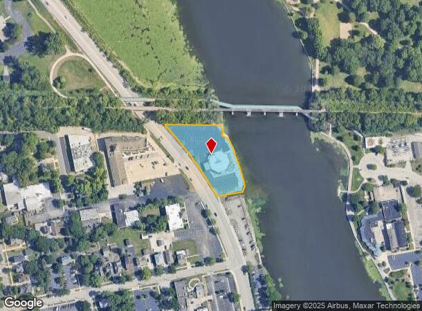
320 N 2Nd St
09-27-354-006
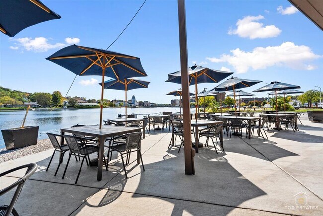
MAP AREA: 147-RESTAURANT
Commercialnec
Kane
AE
Illinois
17089C0262H
0.78 AC
2024
Western East/West Corr
2024
Chicago
852300
Chicago-Naperville-Elgin, IL-IN-WI
6,258 SF
DEMOGRAPHICS near 320 N 2Nd St
1 Mile
3 Mile
5 Mile
2024 Total Population
9,873
55,343
103,100
2029 Population
9,806
54,906
101,755
Pop Growth 2024-2029
(0.68%)
(0.79%)
(1.30%)
Average Age
43
42
41
2024 Total Households
4,263
21,574
38,261
HH Growth 2024-2029
(0.70%)
(0.76%)
(1.26%)
Median Household Inc
$92,174
$118,204
$126,631
Avg Household Size
2.30
2.50
2.60
2024 Avg HH Vehicles
2.00
2.00
2.00
Median Home Value
$342,808
$362,613
$374,081
Median Year Built
1974
1984
1988
Nearby Places
Map Layers
Map Styles
 Street
 Aerial
- Restaurants
- Banks
- Shops
- Fitness
- Groceries
PUBLIC TRANSPORTATION
COMMUTER RAIL
Geneva Station (Union Pacific West Line - Northeast Illinois Regional Commuter Railroad (Metra))
DRIVE
WALK
Distance
Geneva Station (Union Pacific West Line - Northeast Illinois Regional Commuter Railroad (Metra))
7 min
2.8 mi
La Fox Station (Union Pacific West Line - Northeast Illinois Regional Commuter Railroad (Metra))
DRIVE
WALK
Distance
La Fox Station (Union Pacific West Line - Northeast Illinois Regional Commuter Railroad (Metra))
15 min
7.6 mi
AIRPORT
Chicago O'Hare International
DRIVE
WALK
Distance
Chicago O'Hare International
51 min
36.8 mi
Freight Ports
Port Milwaukee
DRIVE
WALK
Distance
Port Milwaukee
129 min
93.1 mi
SALE & LEASE HISTORY
LISTING DATE
SALE/LEASE

Sep 27, 2023
For Lease
Nov 18, 2024
For Sale
Nearby Properties
Address
Land Use
TOTAL SIZE
Lot Size
Zoning
Address
Land Use
TOTAL SIZE
Lot Size
Zoning
404,578 SF
40.29 AC
Address
Land Use
TOTAL SIZE
Lot Size
Zoning
5,482 SF
21.55 AC
Address
Land Use
TOTAL SIZE
Lot Size
Zoning
Address
Land Use
TOTAL SIZE
Lot Size
Zoning
124,474 SF
25.38 AC
Address
Land Use
TOTAL SIZE
Lot Size
Zoning
217,340 SF
15.58 AC
Address
Land Use
TOTAL SIZE
Lot Size
Zoning
Address
Land Use
TOTAL SIZE
Lot Size
Zoning
75.23 AC
Address
Land Use
TOTAL SIZE
Lot Size
Zoning
11.08 AC
Address
Land Use
TOTAL SIZE
Lot Size
Zoning
667,636 SF
38 AC
Address
Land Use
TOTAL SIZE
Lot Size
Zoning
14,138 SF
7.56 AC
Address
Land Use
TOTAL SIZE
Lot Size
Zoning
86,704 SF
0.53 AC
Address
Land Use
TOTAL SIZE
Lot Size
Zoning
306,375 SF
23.82 AC
Address
Land Use
TOTAL SIZE
Lot Size
Zoning
136,208 SF
12.52 AC
Address
Land Use
TOTAL SIZE
Lot Size
Zoning
74,929 SF
6.08 AC
Address
Land Use
TOTAL SIZE
Lot Size
Zoning
Address
Land Use
TOTAL SIZE
Lot Size
Zoning
142,313 SF
15.17 AC
Address
Land Use
TOTAL SIZE
Lot Size
Zoning
4,500 SF
11 AC
Address
Land Use
TOTAL SIZE
Lot Size
Zoning
178,890 SF
34.20 AC
Address
Land Use
TOTAL SIZE
Lot Size
Zoning
14.98 AC
Address
Land Use
TOTAL SIZE
Lot Size
Zoning
36,199 SF
5.84 AC
Address
Land Use
TOTAL SIZE
Lot Size
Zoning
321,702 SF
22.39 AC
Address
Land Use
TOTAL SIZE
Lot Size
Zoning
258,768 SF
28.43 AC
Address
Land Use
TOTAL SIZE
Lot Size
Zoning
Address
Land Use
TOTAL SIZE
Lot Size
Zoning
143,539 SF
19.37 AC
C
Address
Land Use
TOTAL SIZE
Lot Size
Zoning
18,861 SF
135.23 AC
Address
Land Use
TOTAL SIZE
Lot Size
Zoning
3,614 SF
4.46 AC
Address
Land Use
TOTAL SIZE
Lot Size
Zoning
13.46 AC
Address
Land Use
TOTAL SIZE
Lot Size
Zoning
216,354 SF
16.05 AC
Address
Land Use
TOTAL SIZE
Lot Size
Zoning
33,761 SF
2.82 AC
The World's #1 Commercial Real Estate Marketplace
Connect with us
© 2025 CoStar Group
The information above has been obtained from sources believed reliable. While we do not doubt its accuracy we have not verified it and make no guarantee, warranty or representation about it. It is your responsibility to independently confirm its accuracy and completeness. Any projections, opinions, assumptions, or estimates used are for example only and do not represent the current or future performance of the property. The value of this transaction to you depends on tax and other factors which should be evaluated by your tax, financial, and legal advisors. You and your advisors should conduct a careful, independent investigation of the property to determine to your satisfaction the suitability of the property for your needs.