Property Record
320 Progress Way, Sun Prairie, WI 53590
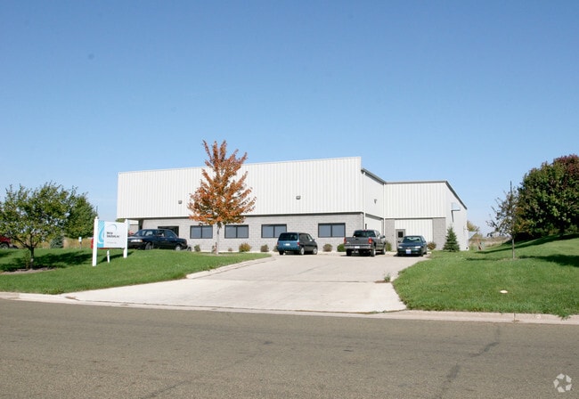

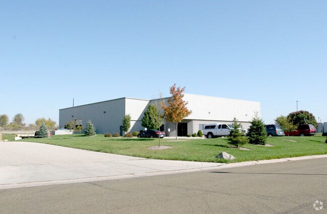
Property Detail
320 Progress Way
Madison, WI
LOT 1 CSM 9738 CS56/161&162-7/18/2000 F/K/A LOT 24 SECOND ADDN TO SUN PRAIRIE BU SINESS PARK DESCR AS SEC 32-9-11 PRT SE1/4NE1/4 & SEC 33-9-11 PRT SW1/4NW1/4 (3. 400 ACRES)
0911-332-4770-2
Dane
Commercialnec
Wisconsin
SI
1,24
B and X Area of moderate flood hazard, usually the area between the limits of the 100-year and 500-year floods.
3.40 AC
2025
Outlying Dane East
2025
Milwaukee/Madison
011600
NEARBY LISTINGS FOR SALE OR LEASE
DEMOGRAPHICS near 320 Progress Way
1 mile
3 mile
5 mile
2025 Total Population
2,710
29,455
45,289
2030 Population
2,835
30,584
47,146
Pop Growth 2025-2030
+ 4.61%
+ 3.83%
+ 4.10%
Average Age
39
38
38
2025 Total Households
1,034
11,279
17,748
HH Growth 2025-2030
+ 4.84%
+ 4.08%
+ 4.40%
Median Household Inc
$87,272
$93,008
$93,142
Avg Household Size
2.60
2.60
2.50
2025 Avg HH Vehicles
2.00
2.00
2.00
Median Home Value
$319,668
$375,918
$388,759
Median Year Built
1982
1991
1995
Nearby Places
Map Layers
Map Styles
 Street
 Aerial
Layers
 Traffic
 Biking
Places
Listings with unknown addresses are not visible on the map
- Restaurants
- Banks
- Shops
- Fitness
- Groceries
PUBLIC TRANSPORTATION
AIRPORT
Dane County Regional/Truax Field
Drive
Walk
Distance
Dane County Regional/Truax Field
19 min
11.6 mi
Nearby Properties
Address
Land Use
TOTAL SIZE
Lot Size
Zoning
Address
Land Use
TOTAL SIZE
Lot Size
Zoning
4.64 AC
Address
Land Use
TOTAL SIZE
Lot Size
Zoning
31,986 SF
5 AC
PD
Address
Land Use
TOTAL SIZE
Lot Size
Zoning
12.16 AC
Address
Land Use
TOTAL SIZE
Lot Size
Zoning
Address
Land Use
TOTAL SIZE
Lot Size
Zoning
147,310 SF
14.68 AC
SC
Address
Land Use
TOTAL SIZE
Lot Size
Zoning
58,272 SF
136.54 AC
SO
Address
Land Use
TOTAL SIZE
Lot Size
Zoning
430,172 SF
18.55 AC
SI
Address
Land Use
TOTAL SIZE
Lot Size
Zoning
24.49 AC
Address
Land Use
TOTAL SIZE
Lot Size
Zoning
16,464 SF
7.37 AC
UR12
Address
Land Use
TOTAL SIZE
Lot Size
Zoning
155,550 SF
21.13 AC
SI
Address
Land Use
TOTAL SIZE
Lot Size
Zoning
Address
Land Use
TOTAL SIZE
Lot Size
Zoning
15,288 SF
14.70 AC
UR12
Address
Land Use
TOTAL SIZE
Lot Size
Zoning
15.24 AC
ABA
Address
Land Use
TOTAL SIZE
Lot Size
Zoning
6.42 AC
Address
Land Use
TOTAL SIZE
Lot Size
Zoning
20,560 SF
6.63 AC
UR12
Address
Land Use
TOTAL SIZE
Lot Size
Zoning
39,676 SF
2.51 AC
UC
Address
Land Use
TOTAL SIZE
Lot Size
Zoning
12.24 AC
Address
Land Use
TOTAL SIZE
Lot Size
Zoning
1.76 AC
Address
Land Use
TOTAL SIZE
Lot Size
Zoning
61,029 SF
6 AC
Address
Land Use
TOTAL SIZE
Lot Size
Zoning
21.09 AC
SI
Address
Land Use
TOTAL SIZE
Lot Size
Zoning
46,035 SF
1.84 AC
PD
Address
Land Use
TOTAL SIZE
Lot Size
Zoning
26,675 SF
5.02 AC
UR12
Address
Land Use
TOTAL SIZE
Lot Size
Zoning
Address
Land Use
TOTAL SIZE
Lot Size
Zoning
12.21 AC
Address
Land Use
TOTAL SIZE
Lot Size
Zoning
Address
Land Use
TOTAL SIZE
Lot Size
Zoning
19,200 SF
9.02 AC
SC
Address
Land Use
TOTAL SIZE
Lot Size
Zoning
2.48 AC
Address
Land Use
TOTAL SIZE
Lot Size
Zoning
8.19 AC
SI
Address
Land Use
TOTAL SIZE
Lot Size
Zoning
3,600 SF
7.75 AC
UI
Address
Land Use
TOTAL SIZE
Lot Size
Zoning
13.09 AC
SI
The World's #1 Commercial Real Estate Marketplace
Connect with us
© 2026 CoStar Group
The information above has been obtained from sources believed reliable. While we do not doubt its accuracy we have not verified it and make no guarantee, warranty or representation about it. It is your responsibility to independently confirm its accuracy and completeness. Any projections, opinions, assumptions, or estimates used are for example only and do not represent the current or future performance of the property. The value of this transaction to you depends on tax and other factors which should be evaluated by your tax, financial, and legal advisors. You and your advisors should conduct a careful, independent investigation of the property to determine to your satisfaction the suitability of the property for your needs.