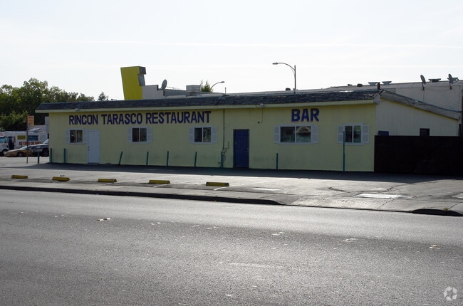
Property Record
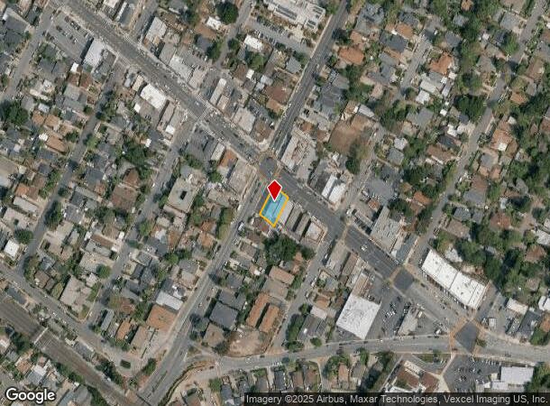
3200 Middlefield Rd, Menlo Park, CA 94025

NEARBY LISTINGS FOR SALE OR LEASE
Property Detail
3200 Middlefield Rd
San Francisco-San Mateo-Redwood City, CA
North Fair Oaks
060-091-250
LOTS 1 & 2 BLOCK 54 LESS PTN TO STREET NORTH FAIR OAKS NO 2 RSM 6/34
Restaurantbuilding
San Mateo
X
California
06081C0302F
1,2
2024
0.15 AC
2025
Redwood City
610601
San Francisco
2,200 SF
DEMOGRAPHICS near 3200 Middlefield Rd
1 mile
3 mile
5 mile
2024 Total Population
23,687
136,954
262,887
2029 Population
22,687
131,316
252,219
Pop Growth 2024-2029
(4.22%)
(4.12%)
(4.06%)
Average Age
39
40
40
2024 Total Households
7,107
49,188
90,801
HH Growth 2024-2029
(4.26%)
(4.12%)
(4.07%)
Median Household Inc
$115,654
$140,970
$148,436
Avg Household Size
3.00
2.60
2.60
2024 Avg HH Vehicles
2.00
2.00
2.00
Median Home Value
$1,117,169
$1,128,995
$1,132,784
Median Year Built
1961
1963
1965
Nearby Places
Map Layers
Map Styles
 Street
 Aerial
Transit
 Traffic
 Biking
Places
Listings with unknown addresses are not visible on the map
- Restaurants
- Banks
- Shops
- Fitness
- Groceries
PUBLIC TRANSPORTATION
COMMUTER RAIL
Redwood City (Caltrain - Caltrain (Caltrain))
Drive
Walk
Distance
Redwood City (Caltrain - Caltrain (Caltrain))
5 min
1.8 mi
Menlo Park (Caltrain - Caltrain (Caltrain))
Drive
Walk
Distance
Menlo Park (Caltrain - Caltrain (Caltrain))
6 min
2.2 mi
AIRPORT
San Francisco International
Drive
Walk
Distance
San Francisco International
24 min
16.4 mi
Norman Y Mineta San Jose International
Drive
Walk
Distance
Norman Y Mineta San Jose International
27 min
18.8 mi
Metro Oakland International
Drive
Walk
Distance
Metro Oakland International
42 min
29.6 mi
Freight Ports
Port of Redwood City
Drive
Walk
Distance
Port of Redwood City
8 min
3.1 mi
Nearby Properties
Address
Land Use
TOTAL SIZE
Lot Size
Zoning
Address
Land Use
TOTAL SIZE
Lot Size
Zoning
719,052 SF
56.03 AC
Address
Land Use
TOTAL SIZE
Lot Size
Zoning
1,395,540 SF
51.72 AC
C3
Address
Land Use
TOTAL SIZE
Lot Size
Zoning
22.07 AC
Address
Land Use
TOTAL SIZE
Lot Size
Zoning
Address
Land Use
TOTAL SIZE
Lot Size
Zoning
520,988 SF
8.88 AC
Address
Land Use
TOTAL SIZE
Lot Size
Zoning
918,926 SF
17.54 AC
PC442
Address
Land Use
TOTAL SIZE
Lot Size
Zoning
723,637 SF
2.09 AC
Address
Land Use
TOTAL SIZE
Lot Size
Zoning
373,238 SF
7.94 AC
Address
Land Use
TOTAL SIZE
Lot Size
Zoning
Address
Land Use
TOTAL SIZE
Lot Size
Zoning
8.31 AC
EA00CA
Address
Land Use
TOTAL SIZE
Lot Size
Zoning
528,437 SF
9.69 AC
Address
Land Use
TOTAL SIZE
Lot Size
Zoning
330,071 SF
1.64 AC
Address
Land Use
TOTAL SIZE
Lot Size
Zoning
210,000 SF
10.79 AC
Address
Land Use
TOTAL SIZE
Lot Size
Zoning
283,015 SF
8.77 AC
Address
Land Use
TOTAL SIZE
Lot Size
Zoning
Address
Land Use
TOTAL SIZE
Lot Size
Zoning
378,534 SF
2.24 AC
Address
Land Use
TOTAL SIZE
Lot Size
Zoning
283,015 SF
7.66 AC
Address
Land Use
TOTAL SIZE
Lot Size
Zoning
247,567 SF
3.52 AC
Address
Land Use
TOTAL SIZE
Lot Size
Zoning
368,000 SF
11.32 AC
Address
Land Use
TOTAL SIZE
Lot Size
Zoning
145,617 SF
8.24 AC
EA00C1
Address
Land Use
TOTAL SIZE
Lot Size
Zoning
61.20 AC
R10000
Address
Land Use
TOTAL SIZE
Lot Size
Zoning
395,625 SF
5.08 AC
Address
Land Use
TOTAL SIZE
Lot Size
Zoning
458,111 SF
2.26 AC
Address
Land Use
TOTAL SIZE
Lot Size
Zoning
2.69 AC
ML001R
Address
Land Use
TOTAL SIZE
Lot Size
Zoning
222,234 SF
6.39 AC
Address
Land Use
TOTAL SIZE
Lot Size
Zoning
Address
Land Use
TOTAL SIZE
Lot Size
Zoning
16.43 AC
Address
Land Use
TOTAL SIZE
Lot Size
Zoning
366,384 SF
3.63 AC
Address
Land Use
TOTAL SIZE
Lot Size
Zoning
249,198 SF
1.14 AC
Address
Land Use
TOTAL SIZE
Lot Size
Zoning
171,563 SF
3.57 AC
The World's #1 Commercial Real Estate Marketplace
Connect with us
© 2026 CoStar Group
The information above has been obtained from sources believed reliable. While we do not doubt its accuracy we have not verified it and make no guarantee, warranty or representation about it. It is your responsibility to independently confirm its accuracy and completeness. Any projections, opinions, assumptions, or estimates used are for example only and do not represent the current or future performance of the property. The value of this transaction to you depends on tax and other factors which should be evaluated by your tax, financial, and legal advisors. You and your advisors should conduct a careful, independent investigation of the property to determine to your satisfaction the suitability of the property for your needs.