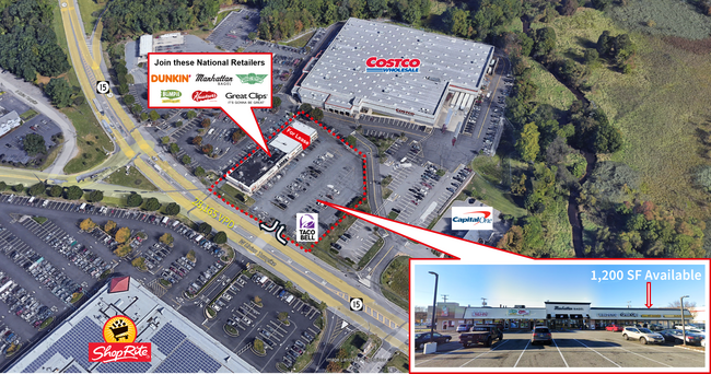
Property Record
321 State Route 15, Wharton, NJ 07885


Property Detail
321 State Route 15
Newark, NJ
Morris
39-00402-0000-00003
New Jersey
Commercialnec
3
I-1
1.44 AC
2024
Western Morris
2025
Northern New Jersey
045100
NEARBY LISTINGS FOR SALE OR LEASE
DEMOGRAPHICS near 321 State Route 15
1 mile
3 mile
5 mile
2025 Total Population
8,013
58,833
116,806
2030 Population
8,272
60,326
119,888
Pop Growth 2025-2030
+ 3.23%
+ 2.54%
+ 2.64%
Average Age
42
41
42
2025 Total Households
3,113
21,380
43,334
HH Growth 2025-2030
+ 3.24%
+ 2.73%
+ 2.77%
Median Household Inc
$101,164
$95,714
$115,169
Avg Household Size
2.50
2.70
2.60
2025 Avg HH Vehicles
2.00
2.00
2.00
Median Home Value
$374,940
$423,001
$450,642
Median Year Built
1971
1967
1968
Nearby Places
Map Layers
Map Styles
 Street
 Aerial
Layers
 Traffic
 Biking
Places
Listings with unknown addresses are not visible on the map
- Restaurants
- Banks
- Shops
- Fitness
- Groceries
PUBLIC TRANSPORTATION
COMMUTER RAIL
Dover (Montclair-Boonton Line - NJ Transit Commuter Rail (NJ Transit), Morris & Essex Morristown Line - NJ Transit Commuter Rail (NJ Transit))
Drive
Walk
Distance
Dover (Montclair-Boonton Line - NJ Transit Commuter Rail (NJ Transit), Morris & Essex Morristown Line - NJ Transit Commuter Rail (NJ Transit))
4 min
2.2 mi
Mount Arlington (Montclair-Boonton Line - NJ Transit Commuter Rail (NJ Transit), Morris & Essex Morristown Line - NJ Transit Commuter Rail (NJ Transit))
Drive
Walk
Distance
Mount Arlington (Montclair-Boonton Line - NJ Transit Commuter Rail (NJ Transit), Morris & Essex Morristown Line - NJ Transit Commuter Rail (NJ Transit))
8 min
5.3 mi
AIRPORT
Newark Liberty International
Drive
Walk
Distance
Newark Liberty International
42 min
31.7 mi
Freight Ports
Maher Terminal
Drive
Walk
Distance
Maher Terminal
45 min
32.2 mi
SALE & LEASE HISTORY
LISTING DATE
SALE/LEASE

Feb 02, 2024
For Lease
Nearby Properties
Address
Land Use
TOTAL SIZE
Lot Size
Zoning
Address
Land Use
TOTAL SIZE
Lot Size
Zoning
1,023 SF
143.31 AC
OR-3
Address
Land Use
TOTAL SIZE
Lot Size
Zoning
6,271.80 AC
R20A
Address
Land Use
TOTAL SIZE
Lot Size
Zoning
401,303 SF
59.54 AC
R-B
Address
Land Use
TOTAL SIZE
Lot Size
Zoning
64.62 AC
R3
Address
Land Use
TOTAL SIZE
Lot Size
Zoning
5,686 SF
557.09 AC
M
Address
Land Use
TOTAL SIZE
Lot Size
Zoning
30.13 AC
I-3
Address
Land Use
TOTAL SIZE
Lot Size
Zoning
95,368 SF
33.81 AC
RMF8
Address
Land Use
TOTAL SIZE
Lot Size
Zoning
23.66 AC
I1
Address
Land Use
TOTAL SIZE
Lot Size
Zoning
20.05 AC
R-1
Address
Land Use
TOTAL SIZE
Lot Size
Zoning
3.01 AC
Address
Land Use
TOTAL SIZE
Lot Size
Zoning
97,716 SF
60.89 AC
0-2
Address
Land Use
TOTAL SIZE
Lot Size
Zoning
Address
Land Use
TOTAL SIZE
Lot Size
Zoning
156,564 SF
19.66 AC
B-2
Address
Land Use
TOTAL SIZE
Lot Size
Zoning
44,600 SF
18.62 AC
R-B
Address
Land Use
TOTAL SIZE
Lot Size
Zoning
195,773 SF
43.54 AC
R-4
Address
Land Use
TOTAL SIZE
Lot Size
Zoning
18.35 AC
RMF8
Address
Land Use
TOTAL SIZE
Lot Size
Zoning
180,636 SF
65.98 AC
I
Address
Land Use
TOTAL SIZE
Lot Size
Zoning
Address
Land Use
TOTAL SIZE
Lot Size
Zoning
19,106 SF
19.25 AC
R-B
Address
Land Use
TOTAL SIZE
Lot Size
Zoning
19.47 AC
R-4
Address
Land Use
TOTAL SIZE
Lot Size
Zoning
8.08 AC
I-1
Address
Land Use
TOTAL SIZE
Lot Size
Zoning
153,609 SF
17.54 AC
R-B
Address
Land Use
TOTAL SIZE
Lot Size
Zoning
13.53 AC
R10
Address
Land Use
TOTAL SIZE
Lot Size
Zoning
261,582 SF
18.38 AC
R-B
Address
Land Use
TOTAL SIZE
Lot Size
Zoning
25.95 AC
I-1
Address
Land Use
TOTAL SIZE
Lot Size
Zoning
38.15 AC
R-1
Address
Land Use
TOTAL SIZE
Lot Size
Zoning
199,694 SF
29.23 AC
B-3
Address
Land Use
TOTAL SIZE
Lot Size
Zoning
30.90 AC
I-2
Address
Land Use
TOTAL SIZE
Lot Size
Zoning
16.21 AC
R-4
Address
Land Use
TOTAL SIZE
Lot Size
Zoning
68,016 SF
6.53 AC
R-B
The World's #1 Commercial Real Estate Marketplace
Connect with us
© 2026 CoStar Group
The information above has been obtained from sources believed reliable. While we do not doubt its accuracy we have not verified it and make no guarantee, warranty or representation about it. It is your responsibility to independently confirm its accuracy and completeness. Any projections, opinions, assumptions, or estimates used are for example only and do not represent the current or future performance of the property. The value of this transaction to you depends on tax and other factors which should be evaluated by your tax, financial, and legal advisors. You and your advisors should conduct a careful, independent investigation of the property to determine to your satisfaction the suitability of the property for your needs.