Property Record
3235 Highland Rd, Baton Rouge, LA 70802


Save to a Folder
{{folder.Name}}
{{folder.ListingIds.length}} Properties
{{folder.ListingIds.length}} Property
Create a New Folder
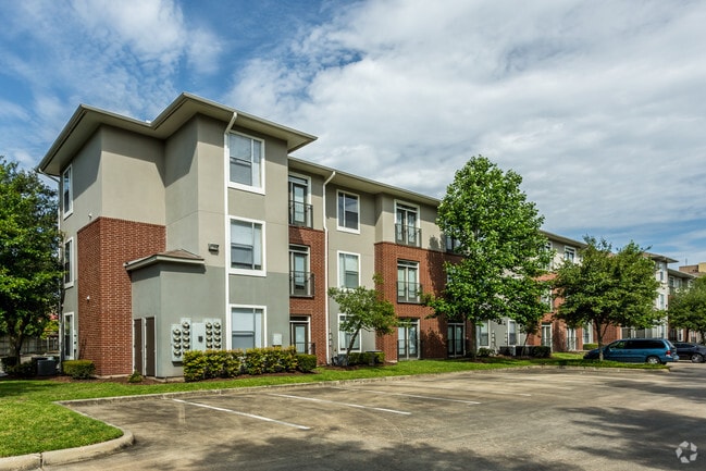
Property Detail
3235 Highland Rd
Baton Rouge, LA
WARD: 1-3, SUBDIVISION: SOUTH BATON ROUGE, LOT: Z-0. 6.53 ACRES TR. Z-0 SOUTH BATON ROUGEFRONTING ON THE E SIDE OF HIGHLANDRO
00890146
East Baton Rouge
Apartment
Louisiana
AE The base floodplain where base flood elevations are provided. AE Zones are now used on new format FIRMs instead of A1-A30 Zones.
z-0
2025
6.53 AC
2025
Highlands/Perkins
002500
Baton Rouge
169,382 SF
NEARBY LISTINGS FOR SALE OR LEASE
DEMOGRAPHICS near 3235 Highland Rd
1 mile
3 mile
5 mile
2025 Total Population
15,426
75,821
146,252
2030 Population
15,779
76,827
147,589
Pop Growth 2025-2030
+ 2.29%
+ 1.33%
+ 0.91%
Average Age
29
34
36
2025 Total Households
4,588
32,187
62,358
HH Growth 2025-2030
+ 3.79%
+ 1.56%
+ 1.02%
Median Household Inc
$30,481
$47,840
$47,239
Avg Household Size
1.90
2.00
2.10
2025 Avg HH Vehicles
1.00
2.00
1.00
Median Home Value
$188,389
$333,928
$281,268
Median Year Built
1976
1977
1977
Nearby Places
Map Layers
Map Styles
 Street
 Aerial
Layers
 Traffic
 Biking
Places
Listings with unknown addresses are not visible on the map
- Restaurants
- Banks
- Shops
- Fitness
- Groceries
PUBLIC TRANSPORTATION
AIRPORT
Baton Rouge Metro Ryan Field
Drive
Walk
Distance
Baton Rouge Metro Ryan Field
17 min
10.0 mi
Freight Ports
Port of Greater Baton Rouge
Drive
Walk
Distance
Port of Greater Baton Rouge
12 min
5.0 mi
Nearby Properties
Address
Land Use
TOTAL SIZE
Lot Size
Zoning
Address
Land Use
TOTAL SIZE
Lot Size
Zoning
Address
Land Use
TOTAL SIZE
Lot Size
Zoning
Address
Land Use
TOTAL SIZE
Lot Size
Zoning
Address
Land Use
TOTAL SIZE
Lot Size
Zoning
Address
Land Use
TOTAL SIZE
Lot Size
Zoning
332,000 SF
1.42 AC
Address
Land Use
TOTAL SIZE
Lot Size
Zoning
290,620 SF
1.76 AC
Address
Land Use
TOTAL SIZE
Lot Size
Zoning
56.77 AC
Address
Land Use
TOTAL SIZE
Lot Size
Zoning
Address
Land Use
TOTAL SIZE
Lot Size
Zoning
8.83 AC
Address
Land Use
TOTAL SIZE
Lot Size
Zoning
5.31 AC
Address
Land Use
TOTAL SIZE
Lot Size
Zoning
303,139 SF
4.37 AC
Address
Land Use
TOTAL SIZE
Lot Size
Zoning
153 AC
Address
Land Use
TOTAL SIZE
Lot Size
Zoning
50,025 SF
6.68 AC
Address
Land Use
TOTAL SIZE
Lot Size
Zoning
25,369 SF
1,200 AC
Address
Land Use
TOTAL SIZE
Lot Size
Zoning
Address
Land Use
TOTAL SIZE
Lot Size
Zoning
681,854 SF
4.50 AC
Address
Land Use
TOTAL SIZE
Lot Size
Zoning
55,755 SF
9.29 AC
Address
Land Use
TOTAL SIZE
Lot Size
Zoning
244,833 SF
0.84 AC
Address
Land Use
TOTAL SIZE
Lot Size
Zoning
2.62 AC
Address
Land Use
TOTAL SIZE
Lot Size
Zoning
76,498 SF
10.93 AC
Address
Land Use
TOTAL SIZE
Lot Size
Zoning
107,326 SF
26.01 AC
Address
Land Use
TOTAL SIZE
Lot Size
Zoning
Address
Land Use
TOTAL SIZE
Lot Size
Zoning
350,000 SF
1.20 AC
Address
Land Use
TOTAL SIZE
Lot Size
Zoning
100,000 SF
Address
Land Use
TOTAL SIZE
Lot Size
Zoning
Address
Land Use
TOTAL SIZE
Lot Size
Zoning
207,577 SF
0.93 AC
Address
Land Use
TOTAL SIZE
Lot Size
Zoning
23,809 SF
5.28 AC
Address
Land Use
TOTAL SIZE
Lot Size
Zoning
Address
Land Use
TOTAL SIZE
Lot Size
Zoning
149,372 SF
0.19 AC
Address
Land Use
TOTAL SIZE
Lot Size
Zoning
243,378 SF
14.59 AC
The World's #1 Commercial Real Estate Marketplace
Connect with us
© 2026 CoStar Group
The information above has been obtained from sources believed reliable. While we do not doubt its accuracy we have not verified it and make no guarantee, warranty or representation about it. It is your responsibility to independently confirm its accuracy and completeness. Any projections, opinions, assumptions, or estimates used are for example only and do not represent the current or future performance of the property. The value of this transaction to you depends on tax and other factors which should be evaluated by your tax, financial, and legal advisors. You and your advisors should conduct a careful, independent investigation of the property to determine to your satisfaction the suitability of the property for your needs.