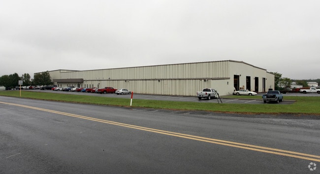
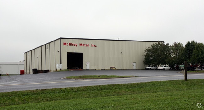
Property Record
325 Mcghee Rd, Winchester, VA 22603

Save to a Folder
{{folder.Name}}
{{folder.ListingIds.length}} Properties
{{folder.ListingIds.length}} Property
Create a New Folder
Property Detail
325 Mcghee Rd
4319-21
4.99 ACRES
Multipleuses
FREDERICK
M1
Virginia
B and X Area of moderate flood hazard, usually the area between the limits of the 100-year and 500-year floods.
4.99 AC
2025
Frederick County VA
2026
Washington, DC
050200
Winchester, VA-WV
84,080 SF
NEARBY LISTINGS FOR SALE OR LEASE
DEMOGRAPHICS near 325 Mcghee Rd
1 mile
3 mile
5 mile
2025 Total Population
416
25,302
64,315
2030 Population
434
25,801
66,154
Pop Growth 2025-2030
+ 4.33%
+ 1.97%
+ 2.86%
Average Age
46
40
40
2025 Total Households
155
9,679
24,371
HH Growth 2025-2030
+ 4.52%
+ 1.79%
+ 2.68%
Median Household Inc
$73,295
$71,092
$79,091
Avg Household Size
2.60
2.50
2.50
2025 Avg HH Vehicles
3.00
2.00
2.00
Median Home Value
$473,809
$326,901
$372,363
Median Year Built
1985
1979
1986
Nearby Places
Map Layers
Map Styles
 Street
 Aerial
Layers
 Traffic
 Biking
Places
Listings with unknown addresses are not visible on the map
- Restaurants
- Banks
- Shops
- Fitness
- Groceries
Nearby Properties
Address
Land Use
TOTAL SIZE
Lot Size
Zoning
Address
Land Use
TOTAL SIZE
Lot Size
Zoning
79,038 SF
128.48 AC
RA
Address
Land Use
TOTAL SIZE
Lot Size
Zoning
47,089 SF
16.84 AC
LR
Address
Land Use
TOTAL SIZE
Lot Size
Zoning
10,821 SF
68.86 AC
RA
Address
Land Use
TOTAL SIZE
Lot Size
Zoning
40,820 SF
31.78 AC
M1
Address
Land Use
TOTAL SIZE
Lot Size
Zoning
2,769 SF
48.27 AC
RP
Address
Land Use
TOTAL SIZE
Lot Size
Zoning
465,856 SF
43.50 AC
M1
Address
Land Use
TOTAL SIZE
Lot Size
Zoning
410,400 SF
27.18 AC
M1
Address
Land Use
TOTAL SIZE
Lot Size
Zoning
161,923 SF
17.10 AC
M1
Address
Land Use
TOTAL SIZE
Lot Size
Zoning
331,272 SF
21.17 AC
M1
Address
Land Use
TOTAL SIZE
Lot Size
Zoning
348,500 SF
26.40 AC
M1
Address
Land Use
TOTAL SIZE
Lot Size
Zoning
328,820 SF
25.05 AC
M1
Address
Land Use
TOTAL SIZE
Lot Size
Zoning
425,580 SF
24.23 AC
M1
Address
Land Use
TOTAL SIZE
Lot Size
Zoning
290,750 SF
19.29 AC
M1
Address
Land Use
TOTAL SIZE
Lot Size
Zoning
332,436 SF
18.09 AC
M1
Address
Land Use
TOTAL SIZE
Lot Size
Zoning
301,116 SF
29.04 AC
M1
Address
Land Use
TOTAL SIZE
Lot Size
Zoning
65,320 SF
2.62 AC
B1
Address
Land Use
TOTAL SIZE
Lot Size
Zoning
347,200 SF
25.50 AC
M1
Address
Land Use
TOTAL SIZE
Lot Size
Zoning
153,024 SF
33.47 AC
EIP
Address
Land Use
TOTAL SIZE
Lot Size
Zoning
1,530 SF
14.10 AC
RP
Address
Land Use
TOTAL SIZE
Lot Size
Zoning
56,746 SF
30 AC
M1
Address
Land Use
TOTAL SIZE
Lot Size
Zoning
84,375 SF
20 AC
R4
Address
Land Use
TOTAL SIZE
Lot Size
Zoning
80,744 SF
21.41 AC
B2
Address
Land Use
TOTAL SIZE
Lot Size
Zoning
5,293 SF
195.07 AC
LR
Address
Land Use
TOTAL SIZE
Lot Size
Zoning
257,491 SF
24.40 AC
M1
Address
Land Use
TOTAL SIZE
Lot Size
Zoning
20,844 SF
11.58 AC
RP
Address
Land Use
TOTAL SIZE
Lot Size
Zoning
151,000 SF
26.91 AC
LR
Address
Land Use
TOTAL SIZE
Lot Size
Zoning
210,800 SF
18.59 AC
M1
Address
Land Use
TOTAL SIZE
Lot Size
Zoning
91,468 SF
7.37 AC
EIP
Address
Land Use
TOTAL SIZE
Lot Size
Zoning
69,975 SF
14.77 AC
B2
Address
Land Use
TOTAL SIZE
Lot Size
Zoning
74,336 SF
9.03 AC
MC
The World's #1 Commercial Real Estate Marketplace
Connect with us
© 2026 CoStar Group
The information above has been obtained from sources believed reliable. While we do not doubt its accuracy we have not verified it and make no guarantee, warranty or representation about it. It is your responsibility to independently confirm its accuracy and completeness. Any projections, opinions, assumptions, or estimates used are for example only and do not represent the current or future performance of the property. The value of this transaction to you depends on tax and other factors which should be evaluated by your tax, financial, and legal advisors. You and your advisors should conduct a careful, independent investigation of the property to determine to your satisfaction the suitability of the property for your needs.