Property Record
325 Midland Pky, Summerville, SC 29485

NEARBY LISTINGS FOR SALE OR LEASE
-
-
View all Summerville listings for sale on LoopNet.com
Property Detail
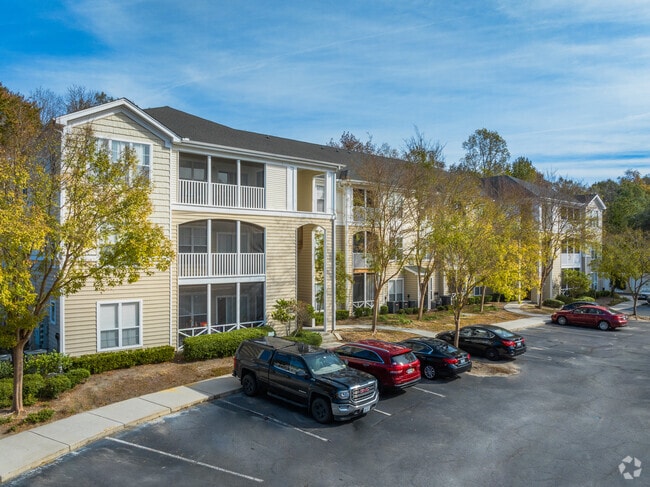
325 Midland Pky
154-00-00-033
Grove At Oakbrook Apt
Apartment
TRACT C SUBD: GROVE AT OAKBROOK APT
X
Dorchester
45019C0260K
South Carolina
2025
11.47 AC
2025
Summerville
010813
Charleston/N Charleston
33,780 SF
Charleston-North Charleston, SC
DEMOGRAPHICS near 325 Midland Pky
1 Mile
3 Mile
5 Mile
2024 Total Population
13,424
65,613
137,275
2029 Population
14,461
70,798
149,354
Pop Growth 2024-2029
+ 7.72%
+ 7.90%
+ 8.80%
Average Age
37
38
38
2024 Total Households
5,286
25,032
52,309
HH Growth 2024-2029
+ 7.68%
+ 7.72%
+ 8.60%
Median Household Inc
$59,319
$71,921
$72,502
Avg Household Size
2.50
2.60
2.60
2024 Avg HH Vehicles
2.00
2.00
2.00
Median Home Value
$219,316
$257,954
$263,112
Median Year Built
2000
2000
1999
Nearby Places
Map Layers
Map Styles
 Street
 Aerial
- Restaurants
- Banks
- Shops
- Fitness
- Groceries
PUBLIC TRANSPORTATION
AIRPORT
Charleston AFB/International
DRIVE
WALK
Distance
Charleston AFB/International
14 min
9.6 mi
Freight Ports
North Charleston Terminal
DRIVE
WALK
Distance
North Charleston Terminal
23 min
14.5 mi
Nearby Properties
Address
Land Use
TOTAL SIZE
Lot Size
Zoning
Address
Land Use
TOTAL SIZE
Lot Size
Zoning
28,770 SF
15.53 AC
Address
Land Use
TOTAL SIZE
Lot Size
Zoning
1,272 SF
18.46 AC
Address
Land Use
TOTAL SIZE
Lot Size
Zoning
Address
Land Use
TOTAL SIZE
Lot Size
Zoning
33.62 AC
Address
Land Use
TOTAL SIZE
Lot Size
Zoning
14.33 AC
Address
Land Use
TOTAL SIZE
Lot Size
Zoning
181,427 SF
16.47 AC
Address
Land Use
TOTAL SIZE
Lot Size
Zoning
194,515 SF
26.73 AC
Address
Land Use
TOTAL SIZE
Lot Size
Zoning
124,678 SF
65.93 AC
Address
Land Use
TOTAL SIZE
Lot Size
Zoning
112.78 AC
Address
Land Use
TOTAL SIZE
Lot Size
Zoning
Address
Land Use
TOTAL SIZE
Lot Size
Zoning
22.80 AC
Address
Land Use
TOTAL SIZE
Lot Size
Zoning
1,332 SF
21.31 AC
Address
Land Use
TOTAL SIZE
Lot Size
Zoning
276,696 SF
17.87 AC
G-B_SV
Address
Land Use
TOTAL SIZE
Lot Size
Zoning
1,350 SF
25.78 AC
Address
Land Use
TOTAL SIZE
Lot Size
Zoning
20,500 SF
1.63 AC
Address
Land Use
TOTAL SIZE
Lot Size
Zoning
299,616 SF
26.90 AC
R-4_DC
Address
Land Use
TOTAL SIZE
Lot Size
Zoning
49.39 AC
PDD_NC
Address
Land Use
TOTAL SIZE
Lot Size
Zoning
3,960 SF
5.51 AC
Address
Land Use
TOTAL SIZE
Lot Size
Zoning
384,000 SF
23.95 AC
PDD_NC
Address
Land Use
TOTAL SIZE
Lot Size
Zoning
236,943 SF
18.74 AC
B-2_NC
Address
Land Use
TOTAL SIZE
Lot Size
Zoning
9,241 SF
9.66 AC
PDD_NC
Address
Land Use
TOTAL SIZE
Lot Size
Zoning
37.71 AC
Address
Land Use
TOTAL SIZE
Lot Size
Zoning
Address
Land Use
TOTAL SIZE
Lot Size
Zoning
339,744 SF
17.75 AC
R-1_NC
Address
Land Use
TOTAL SIZE
Lot Size
Zoning
18.44 AC
Address
Land Use
TOTAL SIZE
Lot Size
Zoning
6,930 SF
4.36 AC
Address
Land Use
TOTAL SIZE
Lot Size
Zoning
102,297 SF
20.14 AC
PDD_NC
Address
Land Use
TOTAL SIZE
Lot Size
Zoning
185,000 SF
28.36 AC
R-2_NC
Address
Land Use
TOTAL SIZE
Lot Size
Zoning
256,996 SF
22.18 AC
R-2_NC
Address
Land Use
TOTAL SIZE
Lot Size
Zoning
20,625 SF
1.43 AC
The World's #1 Commercial Real Estate Marketplace
Connect with us
© 2026 CoStar Group
The information above has been obtained from sources believed reliable. While we do not doubt its accuracy we have not verified it and make no guarantee, warranty or representation about it. It is your responsibility to independently confirm its accuracy and completeness. Any projections, opinions, assumptions, or estimates used are for example only and do not represent the current or future performance of the property. The value of this transaction to you depends on tax and other factors which should be evaluated by your tax, financial, and legal advisors. You and your advisors should conduct a careful, independent investigation of the property to determine to your satisfaction the suitability of the property for your needs.