Property Record
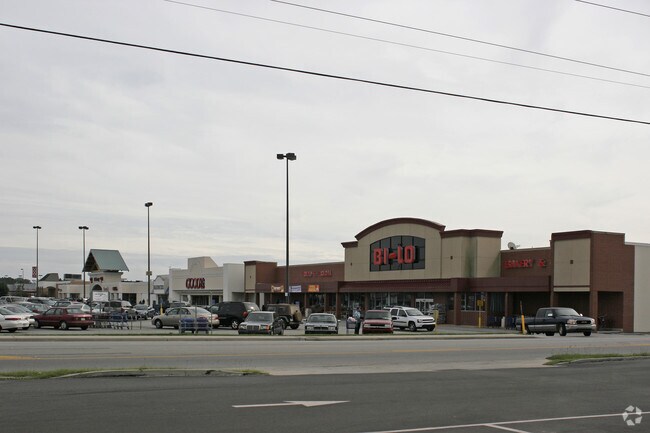
325 Northside Dr E, Statesboro, GA 30458

Property Detail
325 Northside Dr E
MS72000008-002
20.39 AC MALL & BILO/ 325 NSIDE DR E
Regionalshoppingcenterormallwithanchorstore
BULLOCH
CR
Georgia
B and X Area of moderate flood hazard, usually the area between the limits of the 100-year and 500-year floods.
20.39 AC
2025
Georgia South Area
2025
Other Market Areas
110500
Statesboro, GA
102,529 SF
NEARBY LISTINGS FOR SALE OR LEASE
DEMOGRAPHICS near 325 Northside Dr E
1 mile
3 mile
5 mile
2025 Total Population
3,914
36,850
53,243
2030 Population
4,173
38,355
55,892
Pop Growth 2025-2030
+ 6.62%
+ 4.08%
+ 4.98%
Average Age
37
32
33
2025 Total Households
1,683
13,850
19,714
HH Growth 2025-2030
+ 6.89%
+ 4.59%
+ 5.44%
Median Household Inc
$52,810
$44,765
$49,896
Avg Household Size
2.20
2.30
2.40
2025 Avg HH Vehicles
2.00
2.00
2.00
Median Home Value
$188,530
$224,006
$257,688
Median Year Built
1978
1990
1993
Nearby Places
Map Layers
Map Styles
 Street
 Aerial
Layers
 Traffic
 Biking
Places
Listings with unknown addresses are not visible on the map
- Restaurants
- Banks
- Shops
- Fitness
- Groceries
Nearby Properties
Address
Land Use
TOTAL SIZE
Lot Size
Zoning
Address
Land Use
TOTAL SIZE
Lot Size
Zoning
612.82 AC
EXPT
Address
Land Use
TOTAL SIZE
Lot Size
Zoning
250,037 SF
30.67 AC
O
Address
Land Use
TOTAL SIZE
Lot Size
Zoning
9,870 SF
46.47 AC
CR/R4
Address
Land Use
TOTAL SIZE
Lot Size
Zoning
10,228 SF
24.06 AC
R4
Address
Land Use
TOTAL SIZE
Lot Size
Zoning
11,490 SF
10.01 AC
R4
Address
Land Use
TOTAL SIZE
Lot Size
Zoning
7,470 SF
39.71 AC
CR
Address
Land Use
TOTAL SIZE
Lot Size
Zoning
328,813 SF
2.86 AC
CR
Address
Land Use
TOTAL SIZE
Lot Size
Zoning
7,063 SF
22.96 AC
R4
Address
Land Use
TOTAL SIZE
Lot Size
Zoning
5.54 AC
EXPT
Address
Land Use
TOTAL SIZE
Lot Size
Zoning
41.09 AC
R3/R15
Address
Land Use
TOTAL SIZE
Lot Size
Zoning
146,137 SF
17.78 AC
CR
Address
Land Use
TOTAL SIZE
Lot Size
Zoning
55 AC
EXPT
Address
Land Use
TOTAL SIZE
Lot Size
Zoning
3,659 SF
38.60 AC
R40
Address
Land Use
TOTAL SIZE
Lot Size
Zoning
40,906 SF
9.93 AC
R4
Address
Land Use
TOTAL SIZE
Lot Size
Zoning
8,824 SF
29.25 AC
PUD/R4
Address
Land Use
TOTAL SIZE
Lot Size
Zoning
950 SF
12.73 AC
PUD/R4
Address
Land Use
TOTAL SIZE
Lot Size
Zoning
3,552 SF
16.42 AC
PUD/R4/CR
Address
Land Use
TOTAL SIZE
Lot Size
Zoning
22,392 SF
13.97 AC
R4
Address
Land Use
TOTAL SIZE
Lot Size
Zoning
3,727 SF
20.19 AC
CR
Address
Land Use
TOTAL SIZE
Lot Size
Zoning
8,394 SF
14.34 AC
R4/CR
Address
Land Use
TOTAL SIZE
Lot Size
Zoning
60,537 SF
8.76 AC
CR
Address
Land Use
TOTAL SIZE
Lot Size
Zoning
153.74 AC
R40
Address
Land Use
TOTAL SIZE
Lot Size
Zoning
4,450 SF
26.60 AC
R4
Address
Land Use
TOTAL SIZE
Lot Size
Zoning
190,382 SF
23.53 AC
CR
Address
Land Use
TOTAL SIZE
Lot Size
Zoning
13 AC
R20
Address
Land Use
TOTAL SIZE
Lot Size
Zoning
12,010 SF
21.14 AC
HC
Address
Land Use
TOTAL SIZE
Lot Size
Zoning
4,969 SF
13.52 AC
PUD/R4
Address
Land Use
TOTAL SIZE
Lot Size
Zoning
21.05 AC
PUD/R4
Address
Land Use
TOTAL SIZE
Lot Size
Zoning
1,893 SF
10.73 AC
R4
Address
Land Use
TOTAL SIZE
Lot Size
Zoning
61,539 SF
2.50 AC
CR
The World's #1 Commercial Real Estate Marketplace
Connect with us
© 2026 CoStar Group
The information above has been obtained from sources believed reliable. While we do not doubt its accuracy we have not verified it and make no guarantee, warranty or representation about it. It is your responsibility to independently confirm its accuracy and completeness. Any projections, opinions, assumptions, or estimates used are for example only and do not represent the current or future performance of the property. The value of this transaction to you depends on tax and other factors which should be evaluated by your tax, financial, and legal advisors. You and your advisors should conduct a careful, independent investigation of the property to determine to your satisfaction the suitability of the property for your needs.