Property Record
328 W Pima St, Gila Bend, AZ 85337

NEARBY LISTINGS FOR SALE OR LEASE
-
-
View all Gila Bend listings for lease on LoopNet.com
Property Detail
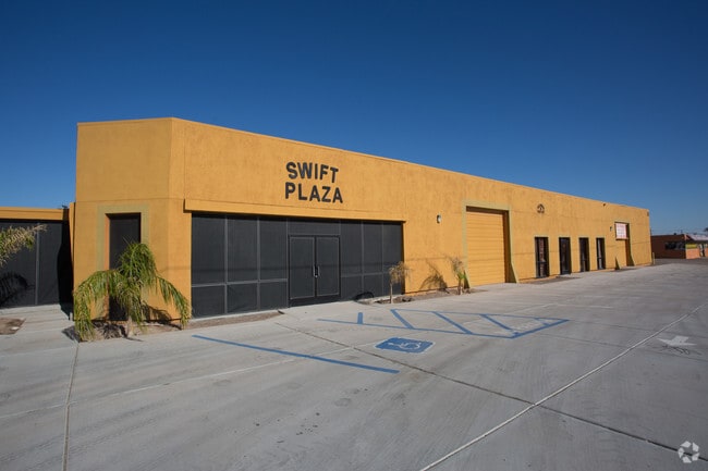
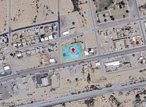
328 W Pima St
Phoenix-Mesa-Chandler, AZ
West Gila Bend Amd
403-11-054A
WEST GILA BEND AMD MCR 32/33
Autorepair
Maricopa
X
Arizona
04013C3555M
d
2025
1.37 AC
2025
W Outlying Maricopa
723305
Phoenix
8,018 SF
DEMOGRAPHICS near 328 W Pima St
1 Mile
3 Mile
5 Mile
2024 Total Population
1,342
1,606
1,624
2029 Population
1,348
1,614
1,633
Pop Growth 2024-2029
+ 0.45%
+ 0.50%
+ 0.55%
Average Age
37
36
36
2024 Total Households
337
415
421
HH Growth 2024-2029
+ 0.30%
+ 0.48%
+ 0.24%
Median Household Inc
$51,842
$47,500
$47,187
Avg Household Size
3.20
3.20
3.20
2024 Avg HH Vehicles
2.00
2.00
2.00
Median Home Value
$80,973
$90,799
$91,666
Median Year Built
1975
1975
1975
Nearby Places
Map Layers
Map Styles
 Street
 Aerial
- Restaurants
- Banks
- Shops
- Fitness
- Groceries
SALE & LEASE HISTORY
LISTING DATE
SALE/LEASE

Dec 20, 2017
For Lease
Nearby Properties
Address
Land Use
TOTAL SIZE
Lot Size
Zoning
Address
Land Use
TOTAL SIZE
Lot Size
Zoning
183,940 SF
40.95 AC
R-7
Address
Land Use
TOTAL SIZE
Lot Size
Zoning
176,889 SF
34.89 AC
I-2
Address
Land Use
TOTAL SIZE
Lot Size
Zoning
11,895 SF
11.01 AC
Address
Land Use
TOTAL SIZE
Lot Size
Zoning
400 AC
SFOZ
Address
Land Use
TOTAL SIZE
Lot Size
Zoning
8,502 SF
1.67 AC
M-M
Address
Land Use
TOTAL SIZE
Lot Size
Zoning
24,405 SF
20.26 AC
I-2
Address
Land Use
TOTAL SIZE
Lot Size
Zoning
311.81 AC
M-M
Address
Land Use
TOTAL SIZE
Lot Size
Zoning
2,068 SF
7.76 AC
R-7
Address
Land Use
TOTAL SIZE
Lot Size
Zoning
99,777 SF
19.10 AC
I-2
Address
Land Use
TOTAL SIZE
Lot Size
Zoning
22,560 SF
1.72 AC
C-C
Address
Land Use
TOTAL SIZE
Lot Size
Zoning
6,058 SF
3.55 AC
C-C
Address
Land Use
TOTAL SIZE
Lot Size
Zoning
5,891 SF
1.84 AC
C-C
Address
Land Use
TOTAL SIZE
Lot Size
Zoning
4,073 SF
5.32 AC
C-C
Address
Land Use
TOTAL SIZE
Lot Size
Zoning
25,841 SF
2.34 AC
C-C
Address
Land Use
TOTAL SIZE
Lot Size
Zoning
43,618 SF
93.59 AC
I-2
Address
Land Use
TOTAL SIZE
Lot Size
Zoning
16,139 SF
3.55 AC
C-C
Address
Land Use
TOTAL SIZE
Lot Size
Zoning
5,529 SF
0.62 AC
C-C
Address
Land Use
TOTAL SIZE
Lot Size
Zoning
2,948 SF
2.38 AC
C-C
Address
Land Use
TOTAL SIZE
Lot Size
Zoning
34,206 SF
6.23 AC
M-H
Address
Land Use
TOTAL SIZE
Lot Size
Zoning
9,504 SF
5.65 AC
I-1
Address
Land Use
TOTAL SIZE
Lot Size
Zoning
2,742 SF
0.46 AC
C-C
Address
Land Use
TOTAL SIZE
Lot Size
Zoning
15,506 SF
1.14 AC
C-C
Address
Land Use
TOTAL SIZE
Lot Size
Zoning
8,000 SF
1.30 AC
C-C
Address
Land Use
TOTAL SIZE
Lot Size
Zoning
8,880 SF
1.37 AC
C-C
Address
Land Use
TOTAL SIZE
Lot Size
Zoning
2,870 SF
23.78 AC
I-2
Address
Land Use
TOTAL SIZE
Lot Size
Zoning
10,440 SF
0.27 AC
C-C
Address
Land Use
TOTAL SIZE
Lot Size
Zoning
19,865 SF
2 AC
M-H
The World's #1 Commercial Real Estate Marketplace
Connect with us
© 2026 CoStar Group
The information above has been obtained from sources believed reliable. While we do not doubt its accuracy we have not verified it and make no guarantee, warranty or representation about it. It is your responsibility to independently confirm its accuracy and completeness. Any projections, opinions, assumptions, or estimates used are for example only and do not represent the current or future performance of the property. The value of this transaction to you depends on tax and other factors which should be evaluated by your tax, financial, and legal advisors. You and your advisors should conduct a careful, independent investigation of the property to determine to your satisfaction the suitability of the property for your needs.