Property Record
330 Mcclellandtown Rd, Uniontown, PA 15401


Save to a Folder
{{folder.Name}}
{{folder.ListingIds.length}} Properties
{{folder.ListingIds.length}} Property
Create a New Folder
Property Detail
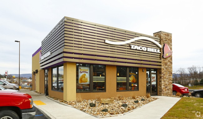
330 Mcclellandtown Rd
34-01-0066-07
0.754 AC RESTAURANT (TACO BELL)
Restaurantbuilding
FAYETTE
B and X Area of moderate flood hazard, usually the area between the limits of the 100-year and 500-year floods.
Pennsylvania
2026
0.75 AC
2026
Fayette County
262000
Pittsburgh
2,026 SF
Pittsburgh, PA
NEARBY LISTINGS FOR SALE OR LEASE
DEMOGRAPHICS near 330 Mcclellandtown Rd
1 mile
3 mile
5 mile
2025 Total Population
2,737
24,293
36,794
2030 Population
2,639
23,737
35,888
Pop Growth 2025-2030
(3.58%)
(2.29%)
(2.46%)
Average Age
46
44
44
2025 Total Households
1,127
10,557
15,948
HH Growth 2025-2030
(3.90%)
(2.48%)
(2.67%)
Median Household Inc
$64,296
$50,841
$53,561
Avg Household Size
2.30
2.20
2.20
2025 Avg HH Vehicles
2.00
2.00
2.00
Median Home Value
$209,091
$161,116
$161,437
Median Year Built
1970
1954
1955
Nearby Places
Map Layers
Map Styles
 Street
 Aerial
Layers
 Traffic
 Biking
Places
Listings with unknown addresses are not visible on the map
- Restaurants
- Banks
- Shops
- Fitness
- Groceries
PUBLIC TRANSPORTATION
AIRPORT
Arnold Palmer Regional
Drive
Walk
Distance
Arnold Palmer Regional
55 min
37.4 mi
Nearby Properties
Address
Land Use
TOTAL SIZE
Lot Size
Zoning
Address
Land Use
TOTAL SIZE
Lot Size
Zoning
339,020 SF
15.05 AC
Address
Land Use
TOTAL SIZE
Lot Size
Zoning
12,737 SF
12.98 AC
Address
Land Use
TOTAL SIZE
Lot Size
Zoning
29.65 AC
Address
Land Use
TOTAL SIZE
Lot Size
Zoning
7,600 SF
59.84 AC
Address
Land Use
TOTAL SIZE
Lot Size
Zoning
Address
Land Use
TOTAL SIZE
Lot Size
Zoning
220,851 SF
21.85 AC
Address
Land Use
TOTAL SIZE
Lot Size
Zoning
Address
Land Use
TOTAL SIZE
Lot Size
Zoning
90,244 SF
3.34 AC
Address
Land Use
TOTAL SIZE
Lot Size
Zoning
8.28 AC
Address
Land Use
TOTAL SIZE
Lot Size
Zoning
124,552 SF
13.30 AC
Address
Land Use
TOTAL SIZE
Lot Size
Zoning
Address
Land Use
TOTAL SIZE
Lot Size
Zoning
776,069 SF
84.42 AC
Address
Land Use
TOTAL SIZE
Lot Size
Zoning
102,792 SF
9.27 AC
Address
Land Use
TOTAL SIZE
Lot Size
Zoning
122,280 SF
5 AC
Address
Land Use
TOTAL SIZE
Lot Size
Zoning
103,488 SF
4.71 AC
Address
Land Use
TOTAL SIZE
Lot Size
Zoning
138,079 SF
22.48 AC
Address
Land Use
TOTAL SIZE
Lot Size
Zoning
150,946 SF
18.12 AC
Address
Land Use
TOTAL SIZE
Lot Size
Zoning
93,409 SF
10.70 AC
Address
Land Use
TOTAL SIZE
Lot Size
Zoning
18,000 SF
24.92 AC
Address
Land Use
TOTAL SIZE
Lot Size
Zoning
17.26 AC
Address
Land Use
TOTAL SIZE
Lot Size
Zoning
60,221 SF
6.66 AC
Address
Land Use
TOTAL SIZE
Lot Size
Zoning
54,512 SF
5.12 AC
Address
Land Use
TOTAL SIZE
Lot Size
Zoning
28,823 SF
6.50 AC
Address
Land Use
TOTAL SIZE
Lot Size
Zoning
58,038 SF
5.20 AC
Address
Land Use
TOTAL SIZE
Lot Size
Zoning
15.73 AC
Address
Land Use
TOTAL SIZE
Lot Size
Zoning
9,464 SF
17 AC
Address
Land Use
TOTAL SIZE
Lot Size
Zoning
55,791 SF
1.96 AC
Address
Land Use
TOTAL SIZE
Lot Size
Zoning
23,616 SF
146.08 AC
Address
Land Use
TOTAL SIZE
Lot Size
Zoning
160,562 SF
15.82 AC
Address
Land Use
TOTAL SIZE
Lot Size
Zoning
3.81 AC
The World's #1 Commercial Real Estate Marketplace
Connect with us
© 2026 CoStar Group
The information above has been obtained from sources believed reliable. While we do not doubt its accuracy we have not verified it and make no guarantee, warranty or representation about it. It is your responsibility to independently confirm its accuracy and completeness. Any projections, opinions, assumptions, or estimates used are for example only and do not represent the current or future performance of the property. The value of this transaction to you depends on tax and other factors which should be evaluated by your tax, financial, and legal advisors. You and your advisors should conduct a careful, independent investigation of the property to determine to your satisfaction the suitability of the property for your needs.