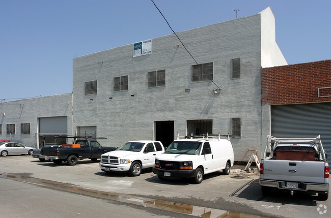
Property Record
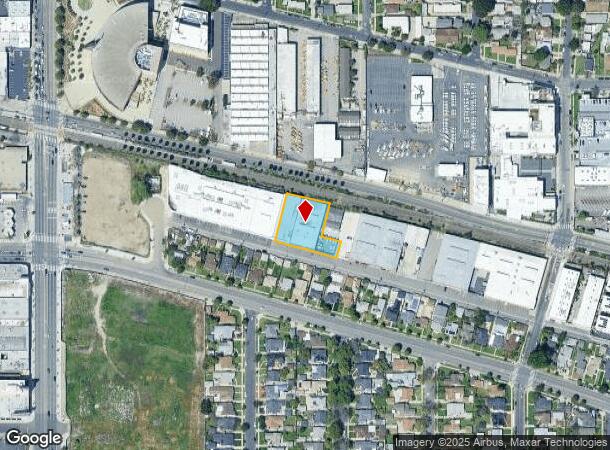
3307 Exposition Pl, Los Angeles, CA 90018

NEARBY LISTINGS FOR SALE OR LEASE
Property Detail
3307 Exposition Pl
Los Angeles-Long Beach-Glendale, CA
12244
5044-002-012
TR=12244 LAND DESC IN DOC 200849,030122 LOTS 46,47 AND POR LOTS 45,48,49
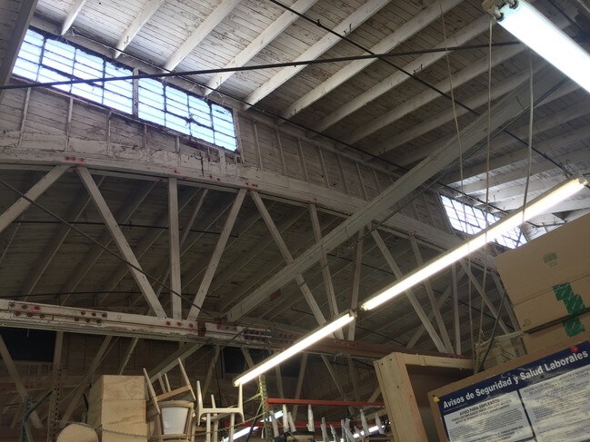
Heavyindustrial
Los Angeles
X
California
06037C1614G
45-49
2024
0.61 AC
2025
Westside
234200
Los Angeles
29,759 SF
DEMOGRAPHICS near 3307 Exposition Pl
1 Mile
3 Mile
5 Mile
2024 Total Population
41,687
389,046
1,229,396
2029 Population
40,613
377,340
1,194,614
Pop Growth 2024-2029
(2.58%)
(3.01%)
(2.83%)
Average Age
40
39
38
2024 Total Households
15,794
136,358
466,460
HH Growth 2024-2029
(2.78%)
(3.15%)
(2.75%)
Median Household Inc
$49,750
$56,284
$61,049
Avg Household Size
2.60
2.70
2.50
2024 Avg HH Vehicles
2.00
2.00
1.00
Median Home Value
$764,982
$840,313
$883,001
Median Year Built
1948
1949
1958
Nearby Places
- Restaurants
- Banks
- Shops
- Fitness
- Groceries
PUBLIC TRANSPORTATION
TRANSIT/SUBWAY
Expo/Crenshaw (Expo Line - Los Angeles County Metropolitan Transportation Authority (Metro))
DRIVE
WALK
Distance
Expo/Crenshaw (Expo Line - Los Angeles County Metropolitan Transportation Authority (Metro))
1 min
3 min
0.2 mi
Farmdale (Expo Line - Los Angeles County Metropolitan Transportation Authority (Metro))
DRIVE
WALK
Distance
Farmdale (Expo Line - Los Angeles County Metropolitan Transportation Authority (Metro))
2 min
15 min
0.8 mi
COMMUTER RAIL
Union Station (91 Line - Southern California Regional Rail Authority (Metrolink), Antelope Valley Line - Southern California Regional Rail Authority (Metrolink), Orange County Line - Southern California Regional Rail Authority (Metrolink), Riverside Line - Southern California Regional Rail Authority (Metrolink), San Bernardino Line - Southern California Regional Rail Authority (Metrolink), Ventura County Line - Southern California Regional Rail Authority (Metrolink))
DRIVE
WALK
Distance
Union Station (91 Line - Southern California Regional Rail Authority (Metrolink), Antelope Valley Line - Southern California Regional Rail Authority (Metrolink), Orange County Line - Southern California Regional Rail Authority (Metrolink), Riverside Line - Southern California Regional Rail Authority (Metrolink), San Bernardino Line - Southern California Regional Rail Authority (Metrolink), Ventura County Line - Southern California Regional Rail Authority (Metrolink))
13 min
8.0 mi
AIRPORT
Los Angeles International
DRIVE
WALK
Distance
Los Angeles International
22 min
11.7 mi
Bob Hope
DRIVE
WALK
Distance
Bob Hope
29 min
22.5 mi
Long Beach (Daugherty Field)
DRIVE
WALK
Distance
Long Beach (Daugherty Field)
29 min
26.6 mi
Freight Ports
Port of Long Beach
DRIVE
WALK
Distance
Port of Long Beach
1 min
19.4 mi
SALE & LEASE HISTORY
LISTING DATE
SALE/LEASE

Oct 28, 2016
For Sale
Oct 28, 2016
For Sale
Oct 28, 2016
For Sale
Jun 26, 2017
For Lease
Jan 30, 2018
For Lease
Nearby Properties
Address
Land Use
TOTAL SIZE
Lot Size
Zoning
Address
Land Use
TOTAL SIZE
Lot Size
Zoning
969,516 SF
14.75 AC
Address
Land Use
TOTAL SIZE
Lot Size
Zoning
420,864 SF
63.07 AC
LAUSC-1A
Address
Land Use
TOTAL SIZE
Lot Size
Zoning
871,235 SF
14.56 AC
LAC2
Address
Land Use
TOTAL SIZE
Lot Size
Zoning
472,363 SF
3.24 AC
LAC4
Address
Land Use
TOTAL SIZE
Lot Size
Zoning
256,059 SF
Address
Land Use
TOTAL SIZE
Lot Size
Zoning
368,411 SF
10.91 AC
C2-2D-CPIO
Address
Land Use
TOTAL SIZE
Lot Size
Zoning
23,312 SF
11.08 AC
C2-2D-CPIO
Address
Land Use
TOTAL SIZE
Lot Size
Zoning
200,689 SF
5.79 AC
LAUSC-1A
Address
Land Use
TOTAL SIZE
Lot Size
Zoning
337,025 SF
14.59 AC
LAUSC-1A
Address
Land Use
TOTAL SIZE
Lot Size
Zoning
666,499 SF
10.63 AC
LAC2
Address
Land Use
TOTAL SIZE
Lot Size
Zoning
786,423 SF
11.74 AC
LAC2
Address
Land Use
TOTAL SIZE
Lot Size
Zoning
78,793 SF
3.53 AC
LAMR1
Address
Land Use
TOTAL SIZE
Lot Size
Zoning
377,946 SF
5.03 AC
LAUSC-1A
Address
Land Use
TOTAL SIZE
Lot Size
Zoning
303,124 SF
2.63 AC
LAC2
Address
Land Use
TOTAL SIZE
Lot Size
Zoning
106,000 SF
4.26 AC
LAMR 1
Address
Land Use
TOTAL SIZE
Lot Size
Zoning
186,798 SF
1.34 AC
LAC1.5
Address
Land Use
TOTAL SIZE
Lot Size
Zoning
237,673 SF
3.73 AC
M1-2D-CPIO
Address
Land Use
TOTAL SIZE
Lot Size
Zoning
190,164 SF
1.18 AC
LAR4
Address
Land Use
TOTAL SIZE
Lot Size
Zoning
73,918 SF
3.86 AC
LAM1
Address
Land Use
TOTAL SIZE
Lot Size
Zoning
31,358 SF
5.43 AC
LAMR
Address
Land Use
TOTAL SIZE
Lot Size
Zoning
303,775 SF
2.27 AC
Address
Land Use
TOTAL SIZE
Lot Size
Zoning
16,172 SF
1.93 AC
LAC2
Address
Land Use
TOTAL SIZE
Lot Size
Zoning
102,877 SF
8.69 AC
LAC2
Address
Land Use
TOTAL SIZE
Lot Size
Zoning
1.05 AC
LAC4
Address
Land Use
TOTAL SIZE
Lot Size
Zoning
112,636 SF
24.20 AC
LAUSC-1A
Address
Land Use
TOTAL SIZE
Lot Size
Zoning
343,879 SF
4.26 AC
LAC2
Address
Land Use
TOTAL SIZE
Lot Size
Zoning
214,155 SF
3.33 AC
CCM1
Address
Land Use
TOTAL SIZE
Lot Size
Zoning
168,636 SF
1.44 AC
LARAS4
Address
Land Use
TOTAL SIZE
Lot Size
Zoning
203,272 SF
14.53 AC
LAC2
Address
Land Use
TOTAL SIZE
Lot Size
Zoning
199,495 SF
1.54 AC
LAR4
The World's #1 Commercial Real Estate Marketplace
Connect with us
© 2025 CoStar Group
The information above has been obtained from sources believed reliable. While we do not doubt its accuracy we have not verified it and make no guarantee, warranty or representation about it. It is your responsibility to independently confirm its accuracy and completeness. Any projections, opinions, assumptions, or estimates used are for example only and do not represent the current or future performance of the property. The value of this transaction to you depends on tax and other factors which should be evaluated by your tax, financial, and legal advisors. You and your advisors should conduct a careful, independent investigation of the property to determine to your satisfaction the suitability of the property for your needs.