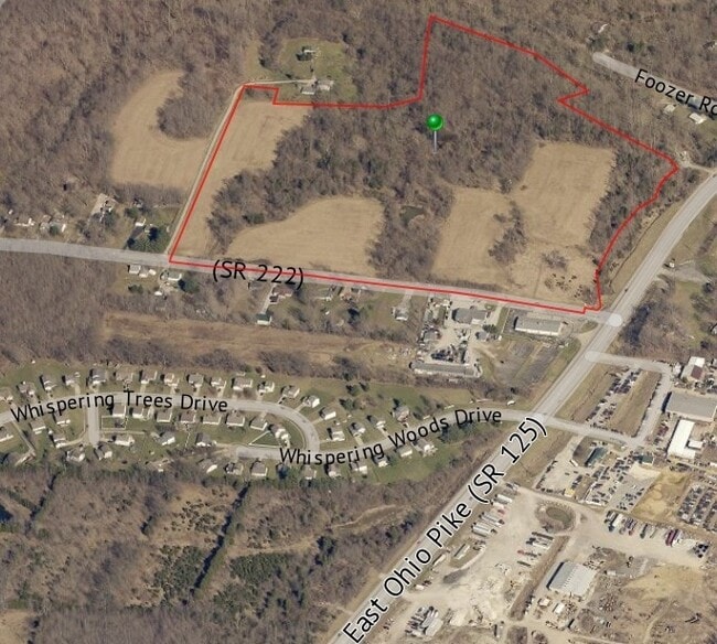
Property Record
3320 State Route 125, Batavia, OH 45103
Property Detail
3320 State Route 125
Cincinnati, OH-KY-IN
06TY 3.237 TO 561.
03-20-19K-039
CLERMONT
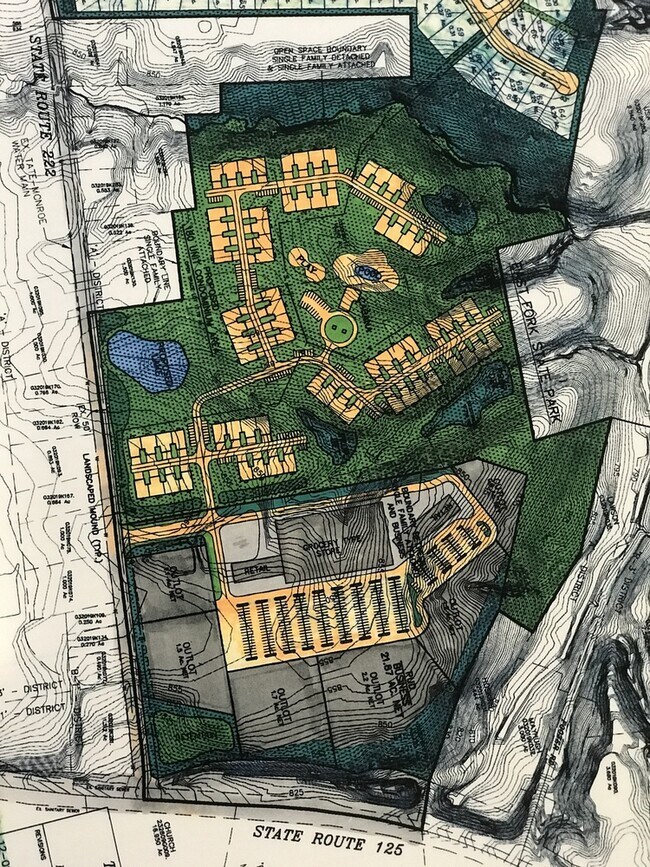
Agriculturalland
Ohio
B and X Area of moderate flood hazard, usually the area between the limits of the 100-year and 500-year floods.
39.27 AC
2025
Outlying Cincinnati East
2025
Cincinnati/Dayton
041002
NEARBY LISTINGS FOR SALE OR LEASE
DEMOGRAPHICS near 3320 State Route 125
1 mile
3 mile
5 mile
2025 Total Population
2,380
15,393
43,692
2030 Population
2,483
16,025
45,134
Pop Growth 2025-2030
+ 4.33%
+ 4.11%
+ 3.30%
Average Age
40
39
39
2025 Total Households
876
5,780
16,375
HH Growth 2025-2030
+ 4.57%
+ 4.13%
+ 3.34%
Median Household Inc
$60,556
$75,033
$78,235
Avg Household Size
2.70
2.60
2.60
2025 Avg HH Vehicles
2.00
2.00
2.00
Median Home Value
$230,386
$228,826
$256,940
Median Year Built
1994
1995
1991
Nearby Places
Map Layers
Map Styles
 Street
 Aerial
Layers
 Traffic
 Biking
Places
Listings with unknown addresses are not visible on the map
- Restaurants
- Banks
- Shops
- Fitness
- Groceries
PUBLIC TRANSPORTATION
AIRPORT
Cincinnati/Northern Kentucky International
Drive
Walk
Distance
Cincinnati/Northern Kentucky International
49 min
31.8 mi
Freight Ports
Port of Toledo
Drive
Walk
Distance
Port of Toledo
258 min
220.2 mi
SALE & LEASE HISTORY
LISTING DATE
SALE/LEASE

May 14, 2020
For Sale
Nearby Properties
Address
Land Use
TOTAL SIZE
Lot Size
Zoning
Address
Land Use
TOTAL SIZE
Lot Size
Zoning
16.02 AC
Address
Land Use
TOTAL SIZE
Lot Size
Zoning
1,380 SF
8.78 AC
Address
Land Use
TOTAL SIZE
Lot Size
Zoning
216,760 SF
26.34 AC
Address
Land Use
TOTAL SIZE
Lot Size
Zoning
19,654 SF
11.57 AC
Address
Land Use
TOTAL SIZE
Lot Size
Zoning
44.65 AC
Address
Land Use
TOTAL SIZE
Lot Size
Zoning
7,200 SF
58.94 AC
Address
Land Use
TOTAL SIZE
Lot Size
Zoning
23,674 SF
3.95 AC
Address
Land Use
TOTAL SIZE
Lot Size
Zoning
10,731 SF
6.92 AC
Address
Land Use
TOTAL SIZE
Lot Size
Zoning
23.04 AC
Address
Land Use
TOTAL SIZE
Lot Size
Zoning
16,100 SF
2.80 AC
Address
Land Use
TOTAL SIZE
Lot Size
Zoning
45,684 SF
6.08 AC
Address
Land Use
TOTAL SIZE
Lot Size
Zoning
10,640 SF
1.27 AC
Address
Land Use
TOTAL SIZE
Lot Size
Zoning
13,318 SF
5 AC
Address
Land Use
TOTAL SIZE
Lot Size
Zoning
2,116 SF
88.91 AC
Address
Land Use
TOTAL SIZE
Lot Size
Zoning
3,456 SF
4.29 AC
Address
Land Use
TOTAL SIZE
Lot Size
Zoning
1,600 SF
5.87 AC
Address
Land Use
TOTAL SIZE
Lot Size
Zoning
2,448 SF
5.58 AC
Address
Land Use
TOTAL SIZE
Lot Size
Zoning
12,150 SF
3.72 AC
Address
Land Use
TOTAL SIZE
Lot Size
Zoning
21,760 SF
5.68 AC
Address
Land Use
TOTAL SIZE
Lot Size
Zoning
10,004 SF
1.38 AC
Address
Land Use
TOTAL SIZE
Lot Size
Zoning
Address
Land Use
TOTAL SIZE
Lot Size
Zoning
Address
Land Use
TOTAL SIZE
Lot Size
Zoning
14,372 SF
4.95 AC
Address
Land Use
TOTAL SIZE
Lot Size
Zoning
8,721 SF
15.69 AC
Address
Land Use
TOTAL SIZE
Lot Size
Zoning
5,702 SF
4.62 AC
Address
Land Use
TOTAL SIZE
Lot Size
Zoning
31.91 AC
Address
Land Use
TOTAL SIZE
Lot Size
Zoning
8,727 SF
1.82 AC
Address
Land Use
TOTAL SIZE
Lot Size
Zoning
5,288 SF
1.17 AC
Address
Land Use
TOTAL SIZE
Lot Size
Zoning
9,100 SF
1.33 AC
Address
Land Use
TOTAL SIZE
Lot Size
Zoning
17,442 SF
0.50 AC
The World's #1 Commercial Real Estate Marketplace
Connect with us
© 2026 CoStar Group
The information above has been obtained from sources believed reliable. While we do not doubt its accuracy we have not verified it and make no guarantee, warranty or representation about it. It is your responsibility to independently confirm its accuracy and completeness. Any projections, opinions, assumptions, or estimates used are for example only and do not represent the current or future performance of the property. The value of this transaction to you depends on tax and other factors which should be evaluated by your tax, financial, and legal advisors. You and your advisors should conduct a careful, independent investigation of the property to determine to your satisfaction the suitability of the property for your needs.