Property Record
3339 Marks Rd, Houston, TX 77084
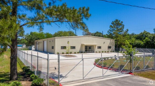

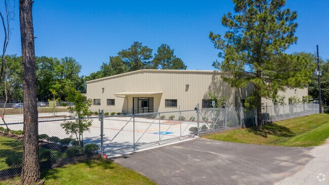

Property Detail
3339 Marks Rd
0440600000016
TR 8B ABST 634 J PAGE
Warehouse
Harris
B and X Area of moderate flood hazard, usually the area between the limits of the 100-year and 500-year floods.
Texas
2024
0.84 AC
2025
Northwest Outliers
541701
Houston
7,735 SF
Houston-Pasadena-The Woodlands, TX
NEARBY LISTINGS FOR SALE OR LEASE
DEMOGRAPHICS near 3339 Marks Rd
1 mile
3 mile
5 mile
2024 Total Population
3,150
88,394
294,467
2029 Population
3,302
93,854
312,431
Pop Growth 2024-2029
+ 4.83%
+ 6.18%
+ 6.10%
Average Age
35
36
37
2024 Total Households
840
29,376
98,199
HH Growth 2024-2029
+ 5.00%
+ 6.48%
+ 6.35%
Median Household Inc
$104,987
$75,658
$84,689
Avg Household Size
3.50
3.00
2.90
2024 Avg HH Vehicles
2.00
2.00
2.00
Median Home Value
$256,399
$264,373
$275,567
Median Year Built
2006
1995
1998
Nearby Places
Map Layers
Map Styles
 Street
 Aerial
Transit
 Traffic
 Biking
Places
Listings with unknown addresses are not visible on the map
- Restaurants
- Banks
- Shops
- Fitness
- Groceries
PUBLIC TRANSPORTATION
AIRPORT
George Bush Intcntl/Houston
Drive
Walk
Distance
George Bush Intcntl/Houston
44 min
31.9 mi
William P Hobby
Drive
Walk
Distance
William P Hobby
54 min
34.2 mi
Freight Ports
Port of Houston
Drive
Walk
Distance
Port of Houston
47 min
31.0 mi
SALE & LEASE HISTORY
LISTING DATE
SALE/LEASE

Oct 01, 2019
For Lease
Nov 16, 2021
For Sale
Mar 02, 2020
For Sale
Jul 01, 2021
For Lease
Nearby Properties
Address
Land Use
TOTAL SIZE
Lot Size
Zoning
Address
Land Use
TOTAL SIZE
Lot Size
Zoning
695,923 SF
6.63 AC
Address
Land Use
TOTAL SIZE
Lot Size
Zoning
681,561 SF
7.98 AC
Address
Land Use
TOTAL SIZE
Lot Size
Zoning
439,347 SF
13.50 AC
Address
Land Use
TOTAL SIZE
Lot Size
Zoning
375,486 SF
12.36 AC
Address
Land Use
TOTAL SIZE
Lot Size
Zoning
341,844 SF
16.71 AC
Address
Land Use
TOTAL SIZE
Lot Size
Zoning
343,605 SF
11.90 AC
Address
Land Use
TOTAL SIZE
Lot Size
Zoning
538,027 SF
30.06 AC
Address
Land Use
TOTAL SIZE
Lot Size
Zoning
320,084 SF
8.01 AC
Address
Land Use
TOTAL SIZE
Lot Size
Zoning
467,663 SF
7.30 AC
Address
Land Use
TOTAL SIZE
Lot Size
Zoning
284,321 SF
10.54 AC
Address
Land Use
TOTAL SIZE
Lot Size
Zoning
458,613 SF
19.50 AC
Address
Land Use
TOTAL SIZE
Lot Size
Zoning
334,724 SF
21.23 AC
Address
Land Use
TOTAL SIZE
Lot Size
Zoning
489,188 SF
5.99 AC
Address
Land Use
TOTAL SIZE
Lot Size
Zoning
294,642 SF
14.47 AC
Address
Land Use
TOTAL SIZE
Lot Size
Zoning
370,329 SF
5 AC
Address
Land Use
TOTAL SIZE
Lot Size
Zoning
363,880 SF
17.32 AC
Address
Land Use
TOTAL SIZE
Lot Size
Zoning
305,624 SF
Address
Land Use
TOTAL SIZE
Lot Size
Zoning
323,753 SF
14.02 AC
Address
Land Use
TOTAL SIZE
Lot Size
Zoning
486,927 SF
5.88 AC
Address
Land Use
TOTAL SIZE
Lot Size
Zoning
170,903 SF
15.53 AC
Address
Land Use
TOTAL SIZE
Lot Size
Zoning
335,483 SF
13.83 AC
Address
Land Use
TOTAL SIZE
Lot Size
Zoning
331,923 SF
13.27 AC
Address
Land Use
TOTAL SIZE
Lot Size
Zoning
229,728 SF
5.92 AC
Address
Land Use
TOTAL SIZE
Lot Size
Zoning
347,192 SF
16.10 AC
Address
Land Use
TOTAL SIZE
Lot Size
Zoning
219,426 SF
10.23 AC
Address
Land Use
TOTAL SIZE
Lot Size
Zoning
262,492 SF
10.04 AC
Address
Land Use
TOTAL SIZE
Lot Size
Zoning
277,552 SF
15.41 AC
Address
Land Use
TOTAL SIZE
Lot Size
Zoning
18.16 AC
Address
Land Use
TOTAL SIZE
Lot Size
Zoning
213,189 SF
1.69 AC
Address
Land Use
TOTAL SIZE
Lot Size
Zoning
392,672 SF
9.73 AC
The World's #1 Commercial Real Estate Marketplace
Connect with us
© 2026 CoStar Group
The information above has been obtained from sources believed reliable. While we do not doubt its accuracy we have not verified it and make no guarantee, warranty or representation about it. It is your responsibility to independently confirm its accuracy and completeness. Any projections, opinions, assumptions, or estimates used are for example only and do not represent the current or future performance of the property. The value of this transaction to you depends on tax and other factors which should be evaluated by your tax, financial, and legal advisors. You and your advisors should conduct a careful, independent investigation of the property to determine to your satisfaction the suitability of the property for your needs.