Property Record
3341 W Illinois Route 64 St, Saint Charles, IL 60175
NEARBY LISTINGS FOR SALE OR LEASE
Property Detail
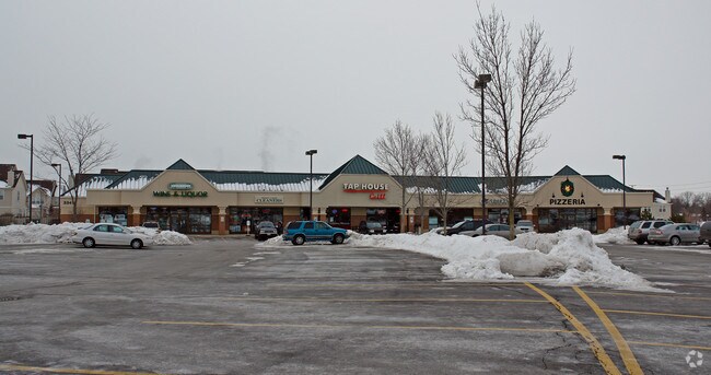
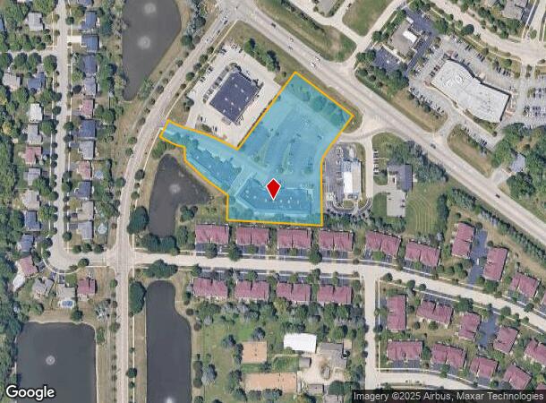
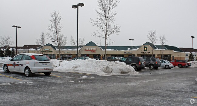
3341 W Illinois Route 64 St
Chicago-Naperville-Elgin, IL-IN-WI
Westgate Commercial
09-29-301-020
WESTGATE COMMERCIAL UNIT 1 LOT 1 (EX AS DESC IN DOC 2006K097926 &2006K097927)
Commercialnec
Kane
X
Illinois
17089C0261H
1
2024
3.42 AC
2024
Western East/West Corr
852404
Chicago
8,575 SF
DEMOGRAPHICS near 3341 W Illinois Route 64 St
1 Mile
3 Mile
5 Mile
2024 Total Population
5,225
40,982
94,074
2029 Population
5,031
40,410
92,862
Pop Growth 2024-2029
(3.71%)
(1.40%)
(1.29%)
Average Age
40
41
42
2024 Total Households
1,756
15,260
34,795
HH Growth 2024-2029
(3.99%)
(1.32%)
(1.25%)
Median Household Inc
$140,598
$130,147
$131,356
Avg Household Size
2.60
2.60
2.60
2024 Avg HH Vehicles
2.00
2.00
2.00
Median Home Value
$359,532
$387,752
$384,497
Median Year Built
2000
1987
1988
Nearby Places
Map Layers
Map Styles
 Street
 Aerial
- Restaurants
- Banks
- Shops
- Fitness
- Groceries
PUBLIC TRANSPORTATION
COMMUTER RAIL
Geneva Station (Union Pacific West Line - Northeast Illinois Regional Commuter Railroad (Metra))
DRIVE
WALK
Distance
Geneva Station (Union Pacific West Line - Northeast Illinois Regional Commuter Railroad (Metra))
9 min
4.3 mi
La Fox Station (Union Pacific West Line - Northeast Illinois Regional Commuter Railroad (Metra))
DRIVE
WALK
Distance
La Fox Station (Union Pacific West Line - Northeast Illinois Regional Commuter Railroad (Metra))
12 min
5.7 mi
AIRPORT
Chicago O'Hare International
DRIVE
WALK
Distance
Chicago O'Hare International
68 min
30.2 mi
Chicago Midway International
DRIVE
WALK
Distance
Chicago Midway International
72 min
39.2 mi
Nearby Properties
Address
Land Use
TOTAL SIZE
Lot Size
Zoning
Address
Land Use
TOTAL SIZE
Lot Size
Zoning
404,578 SF
40.29 AC
Address
Land Use
TOTAL SIZE
Lot Size
Zoning
Address
Land Use
TOTAL SIZE
Lot Size
Zoning
217,340 SF
15.58 AC
Address
Land Use
TOTAL SIZE
Lot Size
Zoning
11.08 AC
Address
Land Use
TOTAL SIZE
Lot Size
Zoning
14,138 SF
7.56 AC
Address
Land Use
TOTAL SIZE
Lot Size
Zoning
86,704 SF
0.53 AC
Address
Land Use
TOTAL SIZE
Lot Size
Zoning
18.42 AC
Address
Land Use
TOTAL SIZE
Lot Size
Zoning
136,208 SF
12.52 AC
Address
Land Use
TOTAL SIZE
Lot Size
Zoning
74,929 SF
6.08 AC
Address
Land Use
TOTAL SIZE
Lot Size
Zoning
Address
Land Use
TOTAL SIZE
Lot Size
Zoning
142,313 SF
15.17 AC
Address
Land Use
TOTAL SIZE
Lot Size
Zoning
Address
Land Use
TOTAL SIZE
Lot Size
Zoning
3,614 SF
4.46 AC
Address
Land Use
TOTAL SIZE
Lot Size
Zoning
33,761 SF
2.82 AC
Address
Land Use
TOTAL SIZE
Lot Size
Zoning
Address
Land Use
TOTAL SIZE
Lot Size
Zoning
Address
Land Use
TOTAL SIZE
Lot Size
Zoning
Address
Land Use
TOTAL SIZE
Lot Size
Zoning
Address
Land Use
TOTAL SIZE
Lot Size
Zoning
Address
Land Use
TOTAL SIZE
Lot Size
Zoning
Address
Land Use
TOTAL SIZE
Lot Size
Zoning
3.53 AC
Address
Land Use
TOTAL SIZE
Lot Size
Zoning
237,265 SF
8.65 AC
Address
Land Use
TOTAL SIZE
Lot Size
Zoning
0.77 AC
Address
Land Use
TOTAL SIZE
Lot Size
Zoning
67,269 SF
7.50 AC
Address
Land Use
TOTAL SIZE
Lot Size
Zoning
9,055 SF
16.14 AC
Address
Land Use
TOTAL SIZE
Lot Size
Zoning
138,862 SF
12.14 AC
Address
Land Use
TOTAL SIZE
Lot Size
Zoning
4,508 SF
5.23 AC
Address
Land Use
TOTAL SIZE
Lot Size
Zoning
81,630 SF
4.56 AC
Address
Land Use
TOTAL SIZE
Lot Size
Zoning
12,360 SF
3.30 AC
The World's #1 Commercial Real Estate Marketplace
Connect with us
© 2025 CoStar Group
The information above has been obtained from sources believed reliable. While we do not doubt its accuracy we have not verified it and make no guarantee, warranty or representation about it. It is your responsibility to independently confirm its accuracy and completeness. Any projections, opinions, assumptions, or estimates used are for example only and do not represent the current or future performance of the property. The value of this transaction to you depends on tax and other factors which should be evaluated by your tax, financial, and legal advisors. You and your advisors should conduct a careful, independent investigation of the property to determine to your satisfaction the suitability of the property for your needs.