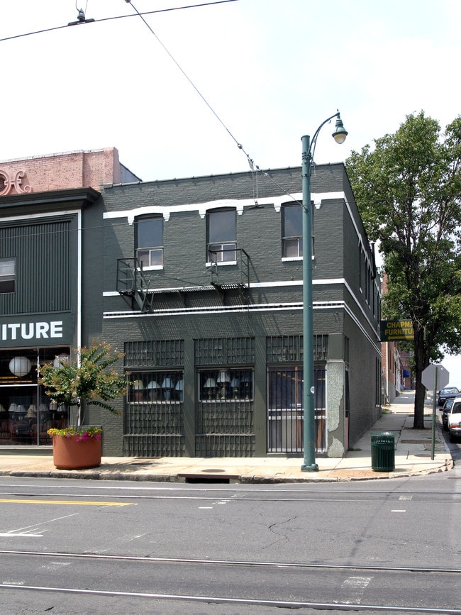
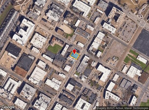
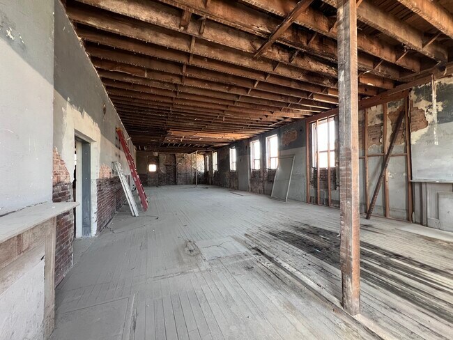
Property Record
337 S Main St, Memphis, TN 38103

This Property Is For Sale
NEARBY LISTINGS FOR SALE OR LEASE
Property Detail
337 S Main St
Memphis, TN-MS-AR
Blk.28
00-2103-0-0004
W.S.MAIN 200 FT N OF TALBOT
Storebuilding
Shelby
X
Tennessee
05035C0375E
5
2024
0.19 AC
2025
Downtown/Midtown
004200
Memphis
13,700 SF
DEMOGRAPHICS near 337 S Main St
1 Mile
3 Mile
5 Mile
2024 Total Population
13,240
67,957
132,943
2029 Population
13,355
68,829
134,382
Pop Growth 2024-2029
+ 0.87%
+ 1.28%
+ 1.08%
Average Age
38
39
39
2024 Total Households
7,347
32,920
61,602
HH Growth 2024-2029
+ 0.84%
+ 0.99%
+ 0.85%
Median Household Inc
$62,769
$39,164
$39,902
Avg Household Size
1.50
1.90
2.00
2024 Avg HH Vehicles
1.00
1.00
1.00
Median Home Value
$367,599
$204,984
$163,468
Median Year Built
1997
1969
1957
Nearby Places
- Restaurants
- Banks
- Shops
- Fitness
- Groceries
PUBLIC TRANSPORTATION
TRANSIT/SUBWAY
Huling Avenue (Main) (Main Street Trolley - Memphis Area Transit Authority Trolley (MataTrolley))
DRIVE
WALK
Distance
Huling Avenue (Main) (Main Street Trolley - Memphis Area Transit Authority Trolley (MataTrolley))
1 min
2 min
0.2 mi
Linden Avenue (Main Street Trolley - Memphis Area Transit Authority Trolley (MataTrolley))
DRIVE
WALK
Distance
Linden Avenue (Main Street Trolley - Memphis Area Transit Authority Trolley (MataTrolley))
1 min
3 min
0.2 mi
Butler Avenue (Main Street Trolley - Memphis Area Transit Authority Trolley (MataTrolley))
DRIVE
WALK
Distance
Butler Avenue (Main Street Trolley - Memphis Area Transit Authority Trolley (MataTrolley))
1 min
5 min
0.3 mi
Beale Street (Main Street Trolley - Memphis Area Transit Authority Trolley (MataTrolley))
DRIVE
WALK
Distance
Beale Street (Main Street Trolley - Memphis Area Transit Authority Trolley (MataTrolley))
1 min
5 min
0.3 mi
Huling Avenue (Riverfront) (Riverfront Loop - Memphis Area Transit Authority Trolley (MataTrolley))
DRIVE
WALK
Distance
Huling Avenue (Riverfront) (Riverfront Loop - Memphis Area Transit Authority Trolley (MataTrolley))
1 min
6 min
0.3 mi
AIRPORT
Memphis International
DRIVE
WALK
Distance
Memphis International
18 min
12.3 mi
Freight Ports
Port of Shreveport
DRIVE
WALK
Distance
Port of Shreveport
1 min
280.9 mi
Nearby Properties
Address
Land Use
TOTAL SIZE
Lot Size
Zoning
Address
Land Use
TOTAL SIZE
Lot Size
Zoning
409,950 SF
5.16 AC
CMP-1
Address
Land Use
TOTAL SIZE
Lot Size
Zoning
660,788 SF
8.28 AC
CMP-1
Address
Land Use
TOTAL SIZE
Lot Size
Zoning
61,983 SF
3.95 AC
U
Address
Land Use
TOTAL SIZE
Lot Size
Zoning
237,575 SF
2.34 AC
SE
Address
Land Use
TOTAL SIZE
Lot Size
Zoning
413,375 SF
33.87 AC
U
Address
Land Use
TOTAL SIZE
Lot Size
Zoning
60,363 SF
1.33 AC
SM
Address
Land Use
TOTAL SIZE
Lot Size
Zoning
300,225 SF
9.61 AC
U
Address
Land Use
TOTAL SIZE
Lot Size
Zoning
182,595 SF
3.17 AC
SE
Address
Land Use
TOTAL SIZE
Lot Size
Zoning
131,803 SF
1.33 AC
CBD
Address
Land Use
TOTAL SIZE
Lot Size
Zoning
138,093 SF
7.05 AC
EMP
Address
Land Use
TOTAL SIZE
Lot Size
Zoning
233,547 SF
16.70 AC
SM
Address
Land Use
TOTAL SIZE
Lot Size
Zoning
71,987 SF
2.26 AC
SM
Address
Land Use
TOTAL SIZE
Lot Size
Zoning
516,768 SF
6.11 AC
CMP-1
Address
Land Use
TOTAL SIZE
Lot Size
Zoning
357,917 SF
2.66 AC
SE
Address
Land Use
TOTAL SIZE
Lot Size
Zoning
81,088 SF
23.12 AC
RU-3
Address
Land Use
TOTAL SIZE
Lot Size
Zoning
79,200 SF
1.91 AC
CMP-1
Address
Land Use
TOTAL SIZE
Lot Size
Zoning
99,590 SF
1.73 AC
SE
Address
Land Use
TOTAL SIZE
Lot Size
Zoning
105,244 SF
0.59 AC
CBD
Address
Land Use
TOTAL SIZE
Lot Size
Zoning
116,399 SF
4.30 AC
SDR
Address
Land Use
TOTAL SIZE
Lot Size
Zoning
113,416 SF
3.35 AC
SDR
Address
Land Use
TOTAL SIZE
Lot Size
Zoning
74,369 SF
0.78 AC
SM
Address
Land Use
TOTAL SIZE
Lot Size
Zoning
56,716 SF
0.49 AC
SE
Address
Land Use
TOTAL SIZE
Lot Size
Zoning
237,434 SF
1.99 AC
CBD
Address
Land Use
TOTAL SIZE
Lot Size
Zoning
57,424 SF
0.83 AC
SM
Address
Land Use
TOTAL SIZE
Lot Size
Zoning
2.20 AC
U
Address
Land Use
TOTAL SIZE
Lot Size
Zoning
109,000 SF
1.18 AC
SE
Address
Land Use
TOTAL SIZE
Lot Size
Zoning
47,430 SF
1.01 AC
CBD
Address
Land Use
TOTAL SIZE
Lot Size
Zoning
76,917 SF
0.60 AC
CBD
Address
Land Use
TOTAL SIZE
Lot Size
Zoning
43,779 SF
2.11 AC
RU-3
Address
Land Use
TOTAL SIZE
Lot Size
Zoning
67,221 SF
0.51 AC
CBD
The World's #1 Commercial Real Estate Marketplace
Connect with us
© 2025 CoStar Group
The information above has been obtained from sources believed reliable. While we do not doubt its accuracy we have not verified it and make no guarantee, warranty or representation about it. It is your responsibility to independently confirm its accuracy and completeness. Any projections, opinions, assumptions, or estimates used are for example only and do not represent the current or future performance of the property. The value of this transaction to you depends on tax and other factors which should be evaluated by your tax, financial, and legal advisors. You and your advisors should conduct a careful, independent investigation of the property to determine to your satisfaction the suitability of the property for your needs.