Property Record
3365 Fulton St, Brooklyn, NY 11208

NEARBY LISTINGS FOR SALE OR LEASE
Property Detail
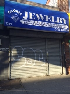
3365 Fulton St
04131-0009
DOCID-2013112500931001
Storebuilding
Kings
X
New York
3604970236F
9
2024
0.08 AC
2025
North Brooklyn
119600
Long Island (New York)
3,250 SF
New York-Jersey City-White Plains, NY-NJ
DEMOGRAPHICS near 3365 Fulton St
1 mile
3 mile
5 mile
2024 Total Population
95,038
774,029
2,259,015
2029 Population
84,766
713,884
2,107,507
Pop Growth 2024-2029
(10.81%)
(7.77%)
(6.71%)
Average Age
38
39
39
2024 Total Households
27,695
269,334
797,654
HH Growth 2024-2029
(11.49%)
(8.05%)
(6.95%)
Median Household Inc
$60,861
$62,817
$66,647
Avg Household Size
3.30
2.70
2.70
2024 Avg HH Vehicles
1.00
1.00
1.00
Median Home Value
$687,090
$706,732
$691,617
Median Year Built
1948
1948
1950
Nearby Places
Map Layers
Map Styles
 Street
 Aerial
Transit
 Traffic
 Biking
Places
Listings with unknown addresses are not visible on the map
- Restaurants
- Banks
- Shops
- Fitness
- Groceries
PUBLIC TRANSPORTATION
TRANSIT/SUBWAY
Crescent Street (J - New York MTA Subway (The Subway), Z - New York MTA Subway (The Subway))
Drive
Walk
Distance
Crescent Street (J - New York MTA Subway (The Subway), Z - New York MTA Subway (The Subway))
1 min
1 min
0.1 mi
75 Street-Elderts Lane (J - New York MTA Subway (The Subway), Z - New York MTA Subway (The Subway))
Drive
Walk
Distance
75 Street-Elderts Lane (J - New York MTA Subway (The Subway), Z - New York MTA Subway (The Subway))
2 min
10 min
0.6 mi
Euclid Avenue (A - New York MTA Subway (The Subway), C - New York MTA Subway (The Subway))
Drive
Walk
Distance
Euclid Avenue (A - New York MTA Subway (The Subway), C - New York MTA Subway (The Subway))
4 min
13 min
0.7 mi
Grant Avenue (A - New York MTA Subway (The Subway))
Drive
Walk
Distance
Grant Avenue (A - New York MTA Subway (The Subway))
4 min
15 min
0.8 mi
COMMUTER RAIL
East New York Station (Far Rockaway Branch - Long Island Rail Road, Long Beach Branch - Long Island Rail Road, West Hempstead Branch - Long Island Rail Road)
Drive
Walk
Distance
East New York Station (Far Rockaway Branch - Long Island Rail Road, Long Beach Branch - Long Island Rail Road, West Hempstead Branch - Long Island Rail Road)
7 min
1.9 mi
Forest Hills Station (Babylon Branch - Long Island Rail Road, Hempstead Branch - Long Island Rail Road, Long Beach Branch - Long Island Rail Road, Port Jefferson Branch - Long Island Rail Road)
Drive
Walk
Distance
Forest Hills Station (Babylon Branch - Long Island Rail Road, Hempstead Branch - Long Island Rail Road, Long Beach Branch - Long Island Rail Road, Port Jefferson Branch - Long Island Rail Road)
14 min
4.4 mi
AIRPORT
John F Kennedy International
Drive
Walk
Distance
John F Kennedy International
13 min
6.5 mi
LaGuardia
Drive
Walk
Distance
LaGuardia
18 min
11.4 mi
Newark Liberty International
Drive
Walk
Distance
Newark Liberty International
47 min
21.1 mi
Nearby Properties
Address
Land Use
TOTAL SIZE
Lot Size
Zoning
Address
Land Use
TOTAL SIZE
Lot Size
Zoning
1,845,252 SF
172 AC
C8-1
Address
Land Use
TOTAL SIZE
Lot Size
Zoning
54,170 SF
229.57 AC
PARK
Address
Land Use
TOTAL SIZE
Lot Size
Zoning
5,302 SF
366.15 AC
PARK
Address
Land Use
TOTAL SIZE
Lot Size
Zoning
1,688,760 SF
24.65 AC
R5
Address
Land Use
TOTAL SIZE
Lot Size
Zoning
1,516,458 SF
5.97 AC
R7-1
Address
Land Use
TOTAL SIZE
Lot Size
Zoning
600 SF
33.07 AC
PARK
Address
Land Use
TOTAL SIZE
Lot Size
Zoning
126.85 AC
PARK
Address
Land Use
TOTAL SIZE
Lot Size
Zoning
24,400 SF
33.98 AC
C4-2
Address
Land Use
TOTAL SIZE
Lot Size
Zoning
1,000 SF
210.07 AC
R3-2
Address
Land Use
TOTAL SIZE
Lot Size
Zoning
1,572,198 SF
22.06 AC
M1-2
Address
Land Use
TOTAL SIZE
Lot Size
Zoning
1,493,793 SF
14.19 AC
R5
Address
Land Use
TOTAL SIZE
Lot Size
Zoning
1,485,000 SF
20.28 AC
R5
Address
Land Use
TOTAL SIZE
Lot Size
Zoning
1,420,000 SF
19.61 AC
R5
Address
Land Use
TOTAL SIZE
Lot Size
Zoning
511,776 SF
2.33 AC
R6
Address
Land Use
TOTAL SIZE
Lot Size
Zoning
575,600 SF
2.35 AC
C4-5X
Address
Land Use
TOTAL SIZE
Lot Size
Zoning
575,600 SF
2.35 AC
C4-5X
Address
Land Use
TOTAL SIZE
Lot Size
Zoning
575,600 SF
2.35 AC
C4-5X
Address
Land Use
TOTAL SIZE
Lot Size
Zoning
575,600 SF
2.35 AC
C4-5X
Address
Land Use
TOTAL SIZE
Lot Size
Zoning
575,600 SF
2.35 AC
C4-5X
Address
Land Use
TOTAL SIZE
Lot Size
Zoning
575,600 SF
2.35 AC
C4-5X
Address
Land Use
TOTAL SIZE
Lot Size
Zoning
575,600 SF
2.35 AC
C4-5X
Address
Land Use
TOTAL SIZE
Lot Size
Zoning
575,600 SF
2.35 AC
C4-5X
Address
Land Use
TOTAL SIZE
Lot Size
Zoning
575,600 SF
2.35 AC
C4-5X
Address
Land Use
TOTAL SIZE
Lot Size
Zoning
575,600 SF
2.35 AC
C4-5X
Address
Land Use
TOTAL SIZE
Lot Size
Zoning
575,600 SF
2.35 AC
C4-5X
Address
Land Use
TOTAL SIZE
Lot Size
Zoning
575,600 SF
2.35 AC
C4-5X
Address
Land Use
TOTAL SIZE
Lot Size
Zoning
575,600 SF
2.35 AC
C4-5X
Address
Land Use
TOTAL SIZE
Lot Size
Zoning
575,600 SF
2.35 AC
C4-5X
Address
Land Use
TOTAL SIZE
Lot Size
Zoning
575,600 SF
2.35 AC
C4-5X
Address
Land Use
TOTAL SIZE
Lot Size
Zoning
575,600 SF
2.35 AC
C4-5X
The World's #1 Commercial Real Estate Marketplace
Connect with us
© 2026 CoStar Group
The information above has been obtained from sources believed reliable. While we do not doubt its accuracy we have not verified it and make no guarantee, warranty or representation about it. It is your responsibility to independently confirm its accuracy and completeness. Any projections, opinions, assumptions, or estimates used are for example only and do not represent the current or future performance of the property. The value of this transaction to you depends on tax and other factors which should be evaluated by your tax, financial, and legal advisors. You and your advisors should conduct a careful, independent investigation of the property to determine to your satisfaction the suitability of the property for your needs.