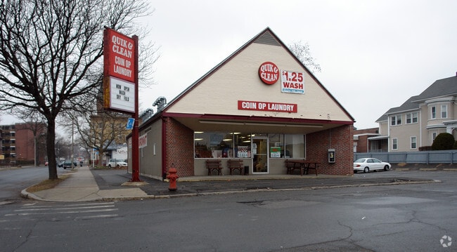
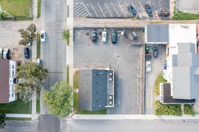
Property Record
337 Appleton St, Holyoke, MA 01040

Property Detail
337 Appleton St
HOLY-000005-000001-000005
Hampden
Storebuilding
Massachusetts
BH
5
B and X Area of moderate flood hazard, usually the area between the limits of the 100-year and 500-year floods.
0.28 AC
2025
Hampden County
2025
Hartford
811700
Springfield, MA
1,573 SF
NEARBY LISTINGS FOR SALE OR LEASE
DEMOGRAPHICS near 337 Appleton St
1 mile
3 mile
5 mile
2024 Total Population
19,296
72,061
144,108
2029 Population
19,407
72,088
144,415
Pop Growth 2024-2029
+ 0.58%
+ 0.04%
+ 0.21%
Average Age
37
41
41
2024 Total Households
7,766
30,484
60,054
HH Growth 2024-2029
+ 0.59%
+ 0.09%
+ 0.25%
Median Household Inc
$35,570
$58,772
$63,794
Avg Household Size
2.30
2.30
2.30
2024 Avg HH Vehicles
1.00
1.00
2.00
Median Home Value
$254,691
$280,445
$290,476
Median Year Built
1948
1954
1962
Nearby Places
Map Layers
Map Styles
 Street
 Aerial
Transit
 Traffic
 Biking
Places
Listings with unknown addresses are not visible on the map
- Restaurants
- Banks
- Shops
- Fitness
- Groceries
PUBLIC TRANSPORTATION
COMMUTER RAIL
Holyoke Amtrak (Valley Flyer - Amtrak, Vermonter - Amtrak)
Drive
Walk
Distance
Holyoke Amtrak (Valley Flyer - Amtrak, Vermonter - Amtrak)
1 min
12 min
0.6 mi
Springfield (Hartford Line - CONN DOT)
Drive
Walk
Distance
Springfield (Hartford Line - CONN DOT)
12 min
8.1 mi
AIRPORT
Bradley International
Drive
Walk
Distance
Bradley International
41 min
20.8 mi
Freight Ports
Port of New Haven
Drive
Walk
Distance
Port of New Haven
93 min
72.4 mi
SALE & LEASE HISTORY
LISTING DATE
SALE/LEASE

Sep 23, 2021
For Sale
Mar 16, 2018
For Sale
Nearby Properties
Address
Land Use
TOTAL SIZE
Lot Size
Zoning
Address
Land Use
TOTAL SIZE
Lot Size
Zoning
22.15 AC
R-1A
Address
Land Use
TOTAL SIZE
Lot Size
Zoning
21.80 AC
106
Address
Land Use
TOTAL SIZE
Lot Size
Zoning
29.88 AC
105
Address
Land Use
TOTAL SIZE
Lot Size
Zoning
189,022 SF
10.62 AC
RA
Address
Land Use
TOTAL SIZE
Lot Size
Zoning
22.77 AC
111A
Address
Land Use
TOTAL SIZE
Lot Size
Zoning
138,504 SF
13.18 AC
RO
Address
Land Use
TOTAL SIZE
Lot Size
Zoning
17.72 AC
R-2
Address
Land Use
TOTAL SIZE
Lot Size
Zoning
171,241 SF
18.94 AC
106
Address
Land Use
TOTAL SIZE
Lot Size
Zoning
30.45 AC
106
Address
Land Use
TOTAL SIZE
Lot Size
Zoning
12.90 AC
IP
Address
Land Use
TOTAL SIZE
Lot Size
Zoning
2.41 AC
DR
Address
Land Use
TOTAL SIZE
Lot Size
Zoning
17.64 AC
105
Address
Land Use
TOTAL SIZE
Lot Size
Zoning
4.04 AC
107
Address
Land Use
TOTAL SIZE
Lot Size
Zoning
8.16 AC
RM40
Address
Land Use
TOTAL SIZE
Lot Size
Zoning
72,239 SF
13.87 AC
R-1A
Address
Land Use
TOTAL SIZE
Lot Size
Zoning
23,111 SF
1.43 AC
IA
Address
Land Use
TOTAL SIZE
Lot Size
Zoning
138,289 SF
22.79 AC
IG
Address
Land Use
TOTAL SIZE
Lot Size
Zoning
4.66 AC
105
Address
Land Use
TOTAL SIZE
Lot Size
Zoning
196,705 SF
21.45 AC
RM20
Address
Land Use
TOTAL SIZE
Lot Size
Zoning
201,410 SF
13.16 AC
RM20
Address
Land Use
TOTAL SIZE
Lot Size
Zoning
191,133 SF
12.28 AC
RM-2
Address
Land Use
TOTAL SIZE
Lot Size
Zoning
62,808 SF
7.60 AC
R-1
Address
Land Use
TOTAL SIZE
Lot Size
Zoning
26.98 AC
BG
Address
Land Use
TOTAL SIZE
Lot Size
Zoning
194,875 SF
2.75 AC
IG
Address
Land Use
TOTAL SIZE
Lot Size
Zoning
64,638 SF
9.26 AC
RA2
Address
Land Use
TOTAL SIZE
Lot Size
Zoning
19.80 AC
105
Address
Land Use
TOTAL SIZE
Lot Size
Zoning
14.47 AC
110
Address
Land Use
TOTAL SIZE
Lot Size
Zoning
116,625 SF
12.73 AC
111A
Address
Land Use
TOTAL SIZE
Lot Size
Zoning
5.88 AC
IG
Address
Land Use
TOTAL SIZE
Lot Size
Zoning
161,190 SF
17.15 AC
RM20
The World's #1 Commercial Real Estate Marketplace
Connect with us
© 2026 CoStar Group
The information above has been obtained from sources believed reliable. While we do not doubt its accuracy we have not verified it and make no guarantee, warranty or representation about it. It is your responsibility to independently confirm its accuracy and completeness. Any projections, opinions, assumptions, or estimates used are for example only and do not represent the current or future performance of the property. The value of this transaction to you depends on tax and other factors which should be evaluated by your tax, financial, and legal advisors. You and your advisors should conduct a careful, independent investigation of the property to determine to your satisfaction the suitability of the property for your needs.