Property Record
3385 Pacheco Pass Hwy, Gilroy, CA 95020
Save to a Folder
{{folder.Name}}
{{folder.ListingIds.length}} Properties
{{folder.ListingIds.length}} Property
Create a New Folder
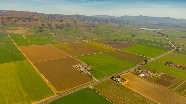
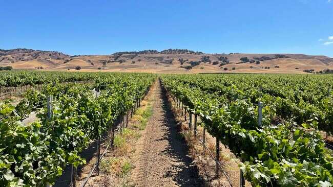
Property Detail
3385 Pacheco Pass Hwy
841-42-012
SANTA CLARA
Orchard
California
HS
78.54 AC
D Areas with possible but undetermined flood hazards.
Outlying Santa Clara Cnty
2024
South Bay/San Jose
2025
San Jose-Sunnyvale-Santa Clara, CA
512602
NEARBY LISTINGS FOR SALE OR LEASE
DEMOGRAPHICS near 3385 Pacheco Pass Hwy
1 mile
3 mile
5 mile
2025 Total Population
107
1,401
36,170
2030 Population
103
1,357
36,791
Pop Growth 2025-2030
(3.74%)
(3.14%)
+ 1.72%
Average Age
44
42
38
2025 Total Households
34
430
10,315
HH Growth 2025-2030
(5.88%)
(3.26%)
+ 1.63%
Median Household Inc
$179,999
$152,809
$115,603
Avg Household Size
3.10
3.10
3.30
2025 Avg HH Vehicles
3.00
3.00
2.00
Median Home Value
$1,060,000
$965,384
$870,445
Median Year Built
1975
1973
1981
Nearby Places
Map Layers
Map Styles
 Street
 Aerial
Layers
 Traffic
 Biking
Places
Listings with unknown addresses are not visible on the map
- Restaurants
- Banks
- Shops
- Fitness
- Groceries
PUBLIC TRANSPORTATION
COMMUTER RAIL
Gilroy Caltrain Station Southbound (South Santa Clara County Connector - Caltrain (Caltrain))
Drive
Walk
Distance
Gilroy Caltrain Station Southbound (South Santa Clara County Connector - Caltrain (Caltrain))
8 min
4.8 mi
Freight Ports
Port of Redwood City
Drive
Walk
Distance
Port of Redwood City
71 min
57.4 mi
SALE & LEASE HISTORY
LISTING DATE
SALE/LEASE

Mar 04, 2020
For Sale
Apr 09, 2021
For Sale
Nearby Properties
Address
Land Use
TOTAL SIZE
Lot Size
Zoning
Address
Land Use
TOTAL SIZE
Lot Size
Zoning
921,750 SF
40.33 AC
M2
Address
Land Use
TOTAL SIZE
Lot Size
Zoning
11.04 AC
M2
Address
Land Use
TOTAL SIZE
Lot Size
Zoning
9.90 AC
M2
Address
Land Use
TOTAL SIZE
Lot Size
Zoning
59.87 AC
M2
Address
Land Use
TOTAL SIZE
Lot Size
Zoning
63,560 SF
7.63 AC
A1-25
Address
Land Use
TOTAL SIZE
Lot Size
Zoning
5.52 AC
M2
Address
Land Use
TOTAL SIZE
Lot Size
Zoning
88,408 SF
7.63 AC
PUD
Address
Land Use
TOTAL SIZE
Lot Size
Zoning
120,665 SF
6.25 AC
M2
Address
Land Use
TOTAL SIZE
Lot Size
Zoning
107,824 SF
12.20 AC
PUD
Address
Land Use
TOTAL SIZE
Lot Size
Zoning
33,569 SF
2.26 AC
M1
Address
Land Use
TOTAL SIZE
Lot Size
Zoning
3 AC
M2
Address
Land Use
TOTAL SIZE
Lot Size
Zoning
184,883 SF
14.92 AC
M2
Address
Land Use
TOTAL SIZE
Lot Size
Zoning
24.54 AC
AW
Address
Land Use
TOTAL SIZE
Lot Size
Zoning
22.45 AC
AW
Address
Land Use
TOTAL SIZE
Lot Size
Zoning
254.18 AC
A-40A
Address
Land Use
TOTAL SIZE
Lot Size
Zoning
25,017 SF
2.74 AC
PUD
Address
Land Use
TOTAL SIZE
Lot Size
Zoning
6,868 SF
1.04 AC
GI
Address
Land Use
TOTAL SIZE
Lot Size
Zoning
8.23 AC
A-40A
Address
Land Use
TOTAL SIZE
Lot Size
Zoning
10.48 AC
A-20S
Address
Land Use
TOTAL SIZE
Lot Size
Zoning
24,759 SF
3.26 AC
PUD
Address
Land Use
TOTAL SIZE
Lot Size
Zoning
8.02 AC
AW
Address
Land Use
TOTAL SIZE
Lot Size
Zoning
85.66 AC
A-40A
Address
Land Use
TOTAL SIZE
Lot Size
Zoning
110.37 AC
A-40A
Address
Land Use
TOTAL SIZE
Lot Size
Zoning
43.77 AC
GI
Address
Land Use
TOTAL SIZE
Lot Size
Zoning
4.42 AC
M1
Address
Land Use
TOTAL SIZE
Lot Size
Zoning
9,449 SF
3.93 AC
M2
Address
Land Use
TOTAL SIZE
Lot Size
Zoning
15,989 SF
1.10 AC
M1
Address
Land Use
TOTAL SIZE
Lot Size
Zoning
17,386 SF
1.15 AC
M2
The World's #1 Commercial Real Estate Marketplace
Connect with us
© 2026 CoStar Group
The information above has been obtained from sources believed reliable. While we do not doubt its accuracy we have not verified it and make no guarantee, warranty or representation about it. It is your responsibility to independently confirm its accuracy and completeness. Any projections, opinions, assumptions, or estimates used are for example only and do not represent the current or future performance of the property. The value of this transaction to you depends on tax and other factors which should be evaluated by your tax, financial, and legal advisors. You and your advisors should conduct a careful, independent investigation of the property to determine to your satisfaction the suitability of the property for your needs.