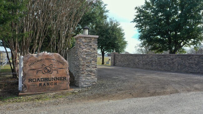
Property Record
339 India Rd, Ferris, TX 75125


Property Detail
339 India Rd
178368
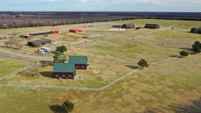
3 R PENA 102.15 ACRES
Farms
ELLIS
A Areas with a 1% annual chance of flooding and a 26% chance of flooding over the life of a 30-year mortgage.
Texas
2024
102.15 AC
2025
Ellis County
060104
Dallas/Ft Worth
8,668 SF
Dallas-Fort Worth-Arlington, TX
NEARBY LISTINGS FOR SALE OR LEASE
DEMOGRAPHICS near 339 India Rd
1 mile
3 mile
5 mile
2025 Total Population
415
2,530
8,588
2030 Population
480
2,932
9,980
Pop Growth 2025-2030
+ 15.66%
+ 15.89%
+ 16.21%
Average Age
39
39
38
2025 Total Households
140
853
2,858
HH Growth 2025-2030
+ 15.71%
+ 15.94%
+ 16.34%
Median Household Inc
$85,897
$86,052
$75,268
Avg Household Size
3.00
3.00
3.00
2025 Avg HH Vehicles
3.00
3.00
2.00
Median Home Value
$284,615
$274,999
$247,584
Median Year Built
1997
1997
1993
Nearby Places
Map Layers
Map Styles
 Street
 Aerial
Layers
 Traffic
 Biking
Places
Listings with unknown addresses are not visible on the map
- Restaurants
- Banks
- Shops
- Fitness
- Groceries
PUBLIC TRANSPORTATION
AIRPORT
Dallas Love Field
Drive
Walk
Distance
Dallas Love Field
44 min
29.8 mi
Freight Ports
Port of Shreveport
Drive
Walk
Distance
Port of Shreveport
224 min
205.7 mi
SALE & LEASE HISTORY
LISTING DATE
SALE/LEASE

Oct 08, 2024
For Sale
Jan 19, 2023
For Sale
Nearby Properties
Address
Land Use
TOTAL SIZE
Lot Size
Zoning
Address
Land Use
TOTAL SIZE
Lot Size
Zoning
116,081 SF
19.03 AC
Address
Land Use
TOTAL SIZE
Lot Size
Zoning
1,214 SF
280.11 AC
Address
Land Use
TOTAL SIZE
Lot Size
Zoning
8,544 SF
1.65 AC
Address
Land Use
TOTAL SIZE
Lot Size
Zoning
2,500 SF
99 AC
Address
Land Use
TOTAL SIZE
Lot Size
Zoning
4,793 SF
5.94 AC
Address
Land Use
TOTAL SIZE
Lot Size
Zoning
8,550 SF
116.86 AC
Address
Land Use
TOTAL SIZE
Lot Size
Zoning
12,656 SF
3 AC
Address
Land Use
TOTAL SIZE
Lot Size
Zoning
8,400 SF
10.57 AC
Address
Land Use
TOTAL SIZE
Lot Size
Zoning
7,694 SF
11.01 AC
Address
Land Use
TOTAL SIZE
Lot Size
Zoning
5,044 SF
5.88 AC
Address
Land Use
TOTAL SIZE
Lot Size
Zoning
10,336 SF
0.99 AC
Address
Land Use
TOTAL SIZE
Lot Size
Zoning
9,674 SF
25 AC
Address
Land Use
TOTAL SIZE
Lot Size
Zoning
2,798 SF
35.84 AC
Address
Land Use
TOTAL SIZE
Lot Size
Zoning
5,703 SF
18.45 AC
Address
Land Use
TOTAL SIZE
Lot Size
Zoning
89.51 AC
Address
Land Use
TOTAL SIZE
Lot Size
Zoning
4,787 SF
2.26 AC
Address
Land Use
TOTAL SIZE
Lot Size
Zoning
3,292 SF
11 AC
Address
Land Use
TOTAL SIZE
Lot Size
Zoning
5,720 SF
19.90 AC
Address
Land Use
TOTAL SIZE
Lot Size
Zoning
2,680 SF
18.27 AC
Address
Land Use
TOTAL SIZE
Lot Size
Zoning
7,492 SF
11.34 AC
Address
Land Use
TOTAL SIZE
Lot Size
Zoning
874 SF
5.48 AC
Address
Land Use
TOTAL SIZE
Lot Size
Zoning
40.49 AC
Address
Land Use
TOTAL SIZE
Lot Size
Zoning
75 AC
Address
Land Use
TOTAL SIZE
Lot Size
Zoning
2,625 SF
5.17 AC
Address
Land Use
TOTAL SIZE
Lot Size
Zoning
5,177 SF
13 AC
Address
Land Use
TOTAL SIZE
Lot Size
Zoning
2,840 SF
12.77 AC
Address
Land Use
TOTAL SIZE
Lot Size
Zoning
3,220 SF
65.35 AC
Address
Land Use
TOTAL SIZE
Lot Size
Zoning
5,549 SF
15.59 AC
Address
Land Use
TOTAL SIZE
Lot Size
Zoning
4,331 SF
142.46 AC
The World's #1 Commercial Real Estate Marketplace
Connect with us
© 2026 CoStar Group
The information above has been obtained from sources believed reliable. While we do not doubt its accuracy we have not verified it and make no guarantee, warranty or representation about it. It is your responsibility to independently confirm its accuracy and completeness. Any projections, opinions, assumptions, or estimates used are for example only and do not represent the current or future performance of the property. The value of this transaction to you depends on tax and other factors which should be evaluated by your tax, financial, and legal advisors. You and your advisors should conduct a careful, independent investigation of the property to determine to your satisfaction the suitability of the property for your needs.