Property Record
3400 E Houston St S, Broken Arrow, OK 74014
NEARBY LISTINGS FOR SALE OR LEASE
Property Detail
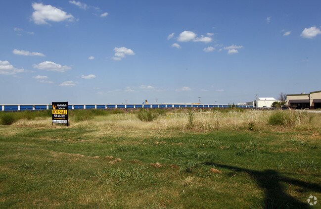
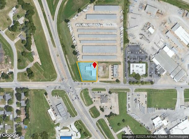
3400 E Houston St S
Tulsa, OK
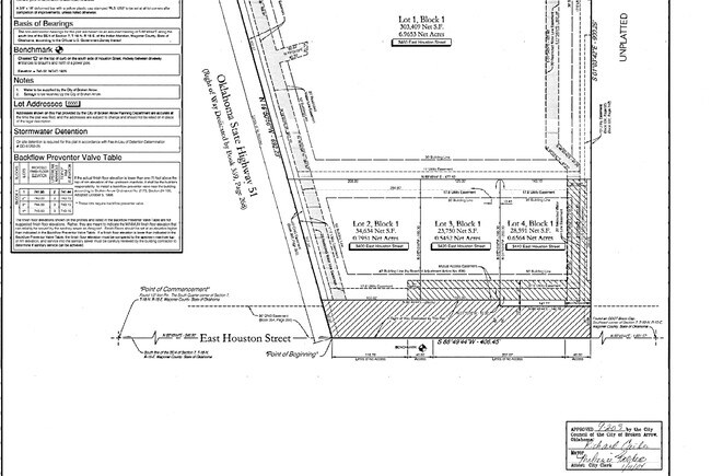
Crossroads Commercial Center
730074282
CROSSROADS COMMERCIAL CENTER LOT 2 BLOCK 1
Storebuilding
Wagoner
X
Oklahoma
40143C0392L
2
2024
0.81 AC
2025
Wagoner County
030502
Tulsa
1,710 SF
DEMOGRAPHICS near 3400 E Houston St S
1 Mile
3 Mile
5 Mile
2024 Total Population
2,407
36,389
117,459
2029 Population
2,796
39,946
126,736
Pop Growth 2024-2029
+ 16.16%
+ 9.77%
+ 7.90%
Average Age
40
39
38
2024 Total Households
884
14,129
43,889
HH Growth 2024-2029
+ 16.06%
+ 9.51%
+ 7.69%
Median Household Inc
$81,588
$69,524
$78,267
Avg Household Size
2.70
2.50
2.60
2024 Avg HH Vehicles
2.00
2.00
2.00
Median Home Value
$173,814
$207,939
$205,571
Median Year Built
1984
1990
1994
Nearby Places
Map Layers
Map Styles
 Street
 Aerial
- Restaurants
- Banks
- Shops
- Fitness
- Groceries
PUBLIC TRANSPORTATION
AIRPORT
Tulsa International
DRIVE
WALK
Distance
Tulsa International
25 min
18.2 mi
Freight Ports
Tulsa Port of Inola
DRIVE
WALK
Distance
Tulsa Port of Inola
32 min
25.0 mi
Nearby Properties
Address
Land Use
TOTAL SIZE
Lot Size
Zoning
Address
Land Use
TOTAL SIZE
Lot Size
Zoning
125,902 SF
19.15 AC
CH
Address
Land Use
TOTAL SIZE
Lot Size
Zoning
75,444 SF
23.92 AC
R1
Address
Land Use
TOTAL SIZE
Lot Size
Zoning
58,695 SF
5.34 AC
RM
Address
Land Use
TOTAL SIZE
Lot Size
Zoning
77,260 SF
0.58 AC
R3
Address
Land Use
TOTAL SIZE
Lot Size
Zoning
67,149 SF
28.56 AC
R2
Address
Land Use
TOTAL SIZE
Lot Size
Zoning
58,627 SF
6.07 AC
CG
Address
Land Use
TOTAL SIZE
Lot Size
Zoning
363,154 SF
23.09 AC
IL
Address
Land Use
TOTAL SIZE
Lot Size
Zoning
39,733 SF
9.36 AC
A1
Address
Land Use
TOTAL SIZE
Lot Size
Zoning
11,601 SF
38.18 AC
RS1
Address
Land Use
TOTAL SIZE
Lot Size
Zoning
13,691 SF
2.04 AC
CH
Address
Land Use
TOTAL SIZE
Lot Size
Zoning
28,071 SF
Address
Land Use
TOTAL SIZE
Lot Size
Zoning
28,348 SF
0.90 AC
DM
Address
Land Use
TOTAL SIZE
Lot Size
Zoning
51,741 SF
2.41 AC
R3
Address
Land Use
TOTAL SIZE
Lot Size
Zoning
60,460 SF
2.28 AC
NCU
Address
Land Use
TOTAL SIZE
Lot Size
Zoning
10,140 SF
18.57 AC
R1
Address
Land Use
TOTAL SIZE
Lot Size
Zoning
23,283 SF
3.94 AC
A1
Address
Land Use
TOTAL SIZE
Lot Size
Zoning
20,633 SF
5.53 AC
Address
Land Use
TOTAL SIZE
Lot Size
Zoning
314,047 SF
12.60 AC
RM
Address
Land Use
TOTAL SIZE
Lot Size
Zoning
12,497 SF
3.31 AC
R1
Address
Land Use
TOTAL SIZE
Lot Size
Zoning
279,184 SF
14.50 AC
RM
Address
Land Use
TOTAL SIZE
Lot Size
Zoning
30,482 SF
4.43 AC
R1
Address
Land Use
TOTAL SIZE
Lot Size
Zoning
27,477 SF
5.79 AC
R1
Address
Land Use
TOTAL SIZE
Lot Size
Zoning
33,004 SF
3.23 AC
R2
Address
Land Use
TOTAL SIZE
Lot Size
Zoning
255,328 SF
27.50 AC
IL
Address
Land Use
TOTAL SIZE
Lot Size
Zoning
11,100 SF
5.30 AC
R1
Address
Land Use
TOTAL SIZE
Lot Size
Zoning
21,960 SF
0.24 AC
CH
Address
Land Use
TOTAL SIZE
Lot Size
Zoning
38,842 SF
0.96 AC
DM
Address
Land Use
TOTAL SIZE
Lot Size
Zoning
10,700 SF
5.99 AC
RM
Address
Land Use
TOTAL SIZE
Lot Size
Zoning
11,795 SF
5.12 AC
R1
The World's #1 Commercial Real Estate Marketplace
Connect with us
© 2026 CoStar Group
The information above has been obtained from sources believed reliable. While we do not doubt its accuracy we have not verified it and make no guarantee, warranty or representation about it. It is your responsibility to independently confirm its accuracy and completeness. Any projections, opinions, assumptions, or estimates used are for example only and do not represent the current or future performance of the property. The value of this transaction to you depends on tax and other factors which should be evaluated by your tax, financial, and legal advisors. You and your advisors should conduct a careful, independent investigation of the property to determine to your satisfaction the suitability of the property for your needs.