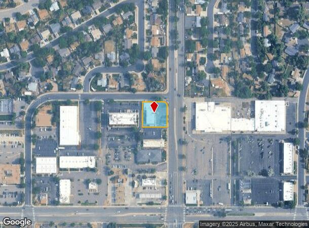
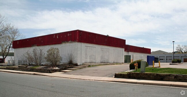
Property Record
3401 S Chambers Rd, Aurora, CO 80014

NEARBY LISTINGS FOR SALE OR LEASE
Property Detail
3401 S Chambers Rd
Denver-Aurora-Centennial, CO
H3a Sub 1St Flg
1975-31-4-30-001
SUBDIVISIONCD 028132 SUBDIVISIONNAME H3A SUB 1ST FLG BLOCK 001 LOT 001 LOT 1 BLK 1 H3A SUB 1ST FLG
Officebuilding
Arapahoe
X
Colorado
08005C0193L
001,1
2024
0.51 AC
2025
Aurora
081600
Denver
9,948 SF
DEMOGRAPHICS near 3401 S Chambers Rd
1 mile
3 mile
5 mile
2024 Total Population
13,964
151,282
372,476
2029 Population
13,918
150,834
373,874
Pop Growth 2024-2029
(0.33%)
(0.30%)
+ 0.38%
Average Age
42
40
38
2024 Total Households
5,086
58,100
143,603
HH Growth 2024-2029
(0.29%)
(0.26%)
+ 0.40%
Median Household Inc
$84,027
$77,025
$78,692
Avg Household Size
2.60
2.50
2.50
2024 Avg HH Vehicles
2.00
2.00
2.00
Median Home Value
$365,554
$391,548
$431,813
Median Year Built
1977
1982
1985
Nearby Places
Map Layers
Map Styles
 Street
 Aerial
Transit
 Traffic
 Biking
Places
Listings with unknown addresses are not visible on the map
- Restaurants
- Banks
- Shops
- Fitness
- Groceries
PUBLIC TRANSPORTATION
AIRPORT
Denver International
Drive
Walk
Distance
Denver International
30 min
22.5 mi
Nearby Properties
Address
Land Use
TOTAL SIZE
Lot Size
Zoning
Address
Land Use
TOTAL SIZE
Lot Size
Zoning
496,493 SF
33.45 AC
Address
Land Use
TOTAL SIZE
Lot Size
Zoning
201,600 SF
44.67 AC
R1
Address
Land Use
TOTAL SIZE
Lot Size
Zoning
525,600 SF
57.90 AC
Address
Land Use
TOTAL SIZE
Lot Size
Zoning
476,186 SF
42.62 AC
Address
Land Use
TOTAL SIZE
Lot Size
Zoning
277,940 SF
31.61 AC
Address
Land Use
TOTAL SIZE
Lot Size
Zoning
50,106 SF
1.67 AC
RB1
Address
Land Use
TOTAL SIZE
Lot Size
Zoning
613,600 SF
29.40 AC
R-3
Address
Land Use
TOTAL SIZE
Lot Size
Zoning
103,811 SF
6.36 AC
RPD
Address
Land Use
TOTAL SIZE
Lot Size
Zoning
55,662 SF
3.71 AC
Address
Land Use
TOTAL SIZE
Lot Size
Zoning
130,531 SF
3.41 AC
Address
Land Use
TOTAL SIZE
Lot Size
Zoning
142,378 SF
14.64 AC
Address
Land Use
TOTAL SIZE
Lot Size
Zoning
383,436 SF
9.77 AC
Address
Land Use
TOTAL SIZE
Lot Size
Zoning
168,500 SF
24.03 AC
Address
Land Use
TOTAL SIZE
Lot Size
Zoning
122,965 SF
12.30 AC
RPD
Address
Land Use
TOTAL SIZE
Lot Size
Zoning
368,462 SF
11.68 AC
RZMF
Address
Land Use
TOTAL SIZE
Lot Size
Zoning
462,048 SF
5.34 AC
RB3
Address
Land Use
TOTAL SIZE
Lot Size
Zoning
105,809 SF
48.79 AC
Address
Land Use
TOTAL SIZE
Lot Size
Zoning
353,956 SF
8.28 AC
R-3
Address
Land Use
TOTAL SIZE
Lot Size
Zoning
345,688 SF
15.15 AC
PUD
Address
Land Use
TOTAL SIZE
Lot Size
Zoning
135,050 SF
19.38 AC
Address
Land Use
TOTAL SIZE
Lot Size
Zoning
105,244 SF
12.64 AC
RPCZD
Address
Land Use
TOTAL SIZE
Lot Size
Zoning
314,961 SF
10.56 AC
R-3
Address
Land Use
TOTAL SIZE
Lot Size
Zoning
104,400 SF
9.32 AC
Address
Land Use
TOTAL SIZE
Lot Size
Zoning
26,880 SF
20.44 AC
Address
Land Use
TOTAL SIZE
Lot Size
Zoning
187,528 SF
6.15 AC
Address
Land Use
TOTAL SIZE
Lot Size
Zoning
34,065 SF
Address
Land Use
TOTAL SIZE
Lot Size
Zoning
220,184 SF
20.45 AC
RPD
Address
Land Use
TOTAL SIZE
Lot Size
Zoning
119,650 SF
10.60 AC
Address
Land Use
TOTAL SIZE
Lot Size
Zoning
172,715 SF
4.23 AC
Address
Land Use
TOTAL SIZE
Lot Size
Zoning
126,087 SF
13.17 AC
The World's #1 Commercial Real Estate Marketplace
Connect with us
© 2026 CoStar Group
The information above has been obtained from sources believed reliable. While we do not doubt its accuracy we have not verified it and make no guarantee, warranty or representation about it. It is your responsibility to independently confirm its accuracy and completeness. Any projections, opinions, assumptions, or estimates used are for example only and do not represent the current or future performance of the property. The value of this transaction to you depends on tax and other factors which should be evaluated by your tax, financial, and legal advisors. You and your advisors should conduct a careful, independent investigation of the property to determine to your satisfaction the suitability of the property for your needs.