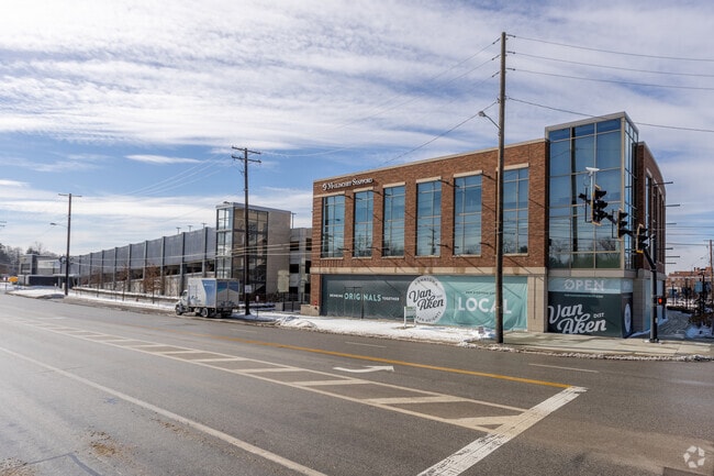
Property Record
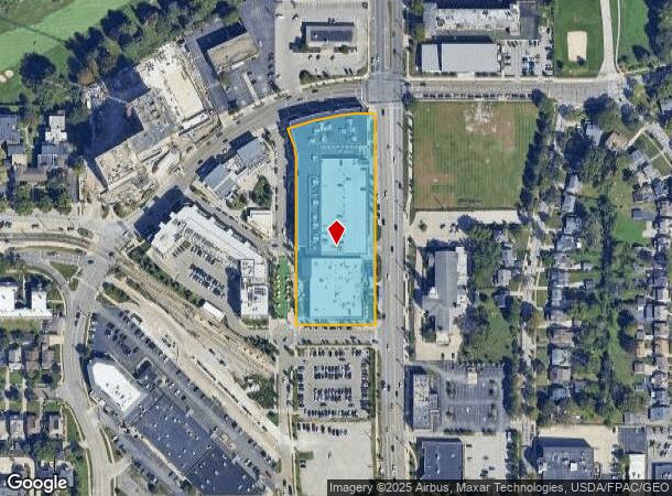
20119 Van Aken Blvd, Beachwood, OH 44122

NEARBY LISTINGS FOR SALE OR LEASE
Property Detail
20119 Van Aken Blvd
736-10-009
2017 S/R VOL GR PAGE 15 OL 45 S/L PCL C FF 553.53 D 235.01 AC 2.6917 VOL 386 PG 19-20 VOL 386 PG 21-22 VOL 386 PG 23-25 73610002 & 003 LISTED WITH 73610009
Regionalshoppingcenterormallwithanchorstore
Cuyahoga
X
Ohio
39035C0208E
2.69 AC
2024
Chagrin Corridor
2024
Cleveland
131105
Cleveland-Elyria, OH
178,694 SF
DEMOGRAPHICS near 20119 Van Aken Blvd
1 mile
3 mile
5 mile
2024 Total Population
12,112
109,360
287,593
2029 Population
11,653
106,647
281,347
Pop Growth 2024-2029
(3.79%)
(2.48%)
(2.17%)
Average Age
43
41
41
2024 Total Households
5,449
46,057
125,004
HH Growth 2024-2029
(3.98%)
(2.67%)
(2.29%)
Median Household Inc
$87,846
$63,416
$53,008
Avg Household Size
2.20
2.30
2.20
2024 Avg HH Vehicles
1.00
2.00
1.00
Median Home Value
$234,055
$175,758
$143,846
Median Year Built
1951
1950
1951
Nearby Places
Map Layers
Map Styles
 Street
 Aerial
Transit
 Traffic
 Biking
Places
Listings with unknown addresses are not visible on the map
- Restaurants
- Banks
- Shops
- Fitness
- Groceries
PUBLIC TRANSPORTATION
AIRPORT
Cleveland-Hopkins International
Drive
Walk
Distance
Cleveland-Hopkins International
33 min
20.6 mi
SALE & LEASE HISTORY
LISTING DATE
SALE/LEASE

Sep 25, 2016
For Lease
Mar 24, 2017
For Lease
Jun 26, 2017
For Lease
Apr 10, 2019
For Lease
Nearby Properties
Address
Land Use
TOTAL SIZE
Lot Size
Zoning
Address
Land Use
TOTAL SIZE
Lot Size
Zoning
975,742 SF
42.03 AC
U-10
Address
Land Use
TOTAL SIZE
Lot Size
Zoning
1,066,853 SF
42.18 AC
U-5
Address
Land Use
TOTAL SIZE
Lot Size
Zoning
418,553 SF
40.99 AC
Address
Land Use
TOTAL SIZE
Lot Size
Zoning
737,998 SF
53.07 AC
U-10
Address
Land Use
TOTAL SIZE
Lot Size
Zoning
475,904 SF
8.04 AC
U-7A
Address
Land Use
TOTAL SIZE
Lot Size
Zoning
68.97 AC
C-1
Address
Land Use
TOTAL SIZE
Lot Size
Zoning
682,144 SF
99.58 AC
C-2
Address
Land Use
TOTAL SIZE
Lot Size
Zoning
729,492 SF
17.67 AC
Address
Land Use
TOTAL SIZE
Lot Size
Zoning
323,733 SF
106.35 AC
MRC2
Address
Land Use
TOTAL SIZE
Lot Size
Zoning
233,767 SF
36.30 AC
U-1A1
Address
Land Use
TOTAL SIZE
Lot Size
Zoning
257,564 SF
2.70 AC
U-4A
Address
Land Use
TOTAL SIZE
Lot Size
Zoning
246,578 SF
28.60 AC
U-5
Address
Land Use
TOTAL SIZE
Lot Size
Zoning
333,582 SF
3.67 AC
U-1A1
Address
Land Use
TOTAL SIZE
Lot Size
Zoning
360,712 SF
55.30 AC
INS
Address
Land Use
TOTAL SIZE
Lot Size
Zoning
485,482 SF
9.60 AC
U-8A
Address
Land Use
TOTAL SIZE
Lot Size
Zoning
78,838 SF
4.90 AC
U-7A
Address
Land Use
TOTAL SIZE
Lot Size
Zoning
232,078 SF
24.89 AC
U-7
Address
Land Use
TOTAL SIZE
Lot Size
Zoning
413,626 SF
21.95 AC
S2
Address
Land Use
TOTAL SIZE
Lot Size
Zoning
119,418 SF
42.99 AC
U-5
Address
Land Use
TOTAL SIZE
Lot Size
Zoning
357,252 SF
10.80 AC
U-8A
Address
Land Use
TOTAL SIZE
Lot Size
Zoning
92,058 SF
31.37 AC
INS
Address
Land Use
TOTAL SIZE
Lot Size
Zoning
143,512 SF
16 AC
Address
Land Use
TOTAL SIZE
Lot Size
Zoning
204,701 SF
10.12 AC
Address
Land Use
TOTAL SIZE
Lot Size
Zoning
4,414 SF
112.92 AC
U-10
Address
Land Use
TOTAL SIZE
Lot Size
Zoning
99,919 SF
17.91 AC
U-1A1
Address
Land Use
TOTAL SIZE
Lot Size
Zoning
108,198 SF
25.45 AC
U-5
Address
Land Use
TOTAL SIZE
Lot Size
Zoning
96,262 SF
10 AC
U-5
Address
Land Use
TOTAL SIZE
Lot Size
Zoning
60,001 SF
8.29 AC
Address
Land Use
TOTAL SIZE
Lot Size
Zoning
18,898 SF
3.57 AC
U-3
Address
Land Use
TOTAL SIZE
Lot Size
Zoning
82,834 SF
21.10 AC
U-5
The World's #1 Commercial Real Estate Marketplace
Connect with us
© 2026 CoStar Group
The information above has been obtained from sources believed reliable. While we do not doubt its accuracy we have not verified it and make no guarantee, warranty or representation about it. It is your responsibility to independently confirm its accuracy and completeness. Any projections, opinions, assumptions, or estimates used are for example only and do not represent the current or future performance of the property. The value of this transaction to you depends on tax and other factors which should be evaluated by your tax, financial, and legal advisors. You and your advisors should conduct a careful, independent investigation of the property to determine to your satisfaction the suitability of the property for your needs.