Property Record
342 Georgia St, Vallejo, CA 94590


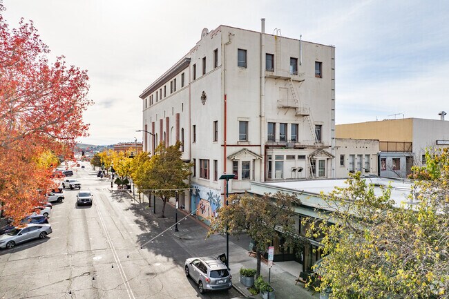

Property Detail
342 Georgia St
Vallejo, CA
BK-BG 00-00
0056-191-120
SOLANO
Nightclub
California
B and X Area of moderate flood hazard, usually the area between the limits of the 100-year and 500-year floods.
8
2024
0.15 AC
2025
Vallejo
250900
North Bay/Santa Rosa
NEARBY LISTINGS FOR SALE OR LEASE
DEMOGRAPHICS near 342 Georgia St
1 mile
3 mile
5 mile
2025 Total Population
15,845
87,135
157,186
2030 Population
16,047
87,890
157,925
Pop Growth 2025-2030
+ 1.27%
+ 0.87%
+ 0.47%
Average Age
40
41
41
2025 Total Households
6,540
31,422
54,084
HH Growth 2025-2030
+ 1.31%
+ 0.95%
+ 0.59%
Median Household Inc
$51,460
$78,156
$93,442
Avg Household Size
2.40
2.70
2.80
2025 Avg HH Vehicles
1.00
2.00
2.00
Median Home Value
$630,269
$618,282
$668,620
Median Year Built
1948
1964
1974
Nearby Places
Map Layers
Map Styles
 Street
 Aerial
Layers
 Traffic
 Biking
Places
Listings with unknown addresses are not visible on the map
- Restaurants
- Banks
- Shops
- Fitness
- Groceries
PUBLIC TRANSPORTATION
AIRPORT
Metro Oakland International
Drive
Walk
Distance
Metro Oakland International
47 min
35.9 mi
San Francisco International
Drive
Walk
Distance
San Francisco International
60 min
43.5 mi
SALE & LEASE HISTORY
LISTING DATE
SALE/LEASE

Mar 10, 2025
For Lease
Aug 06, 2021
For Lease
Nearby Properties
Address
Land Use
TOTAL SIZE
Lot Size
Zoning
Address
Land Use
TOTAL SIZE
Lot Size
Zoning
432,550 SF
29.70 AC
Address
Land Use
TOTAL SIZE
Lot Size
Zoning
108.37 AC
Address
Land Use
TOTAL SIZE
Lot Size
Zoning
349.61 AC
Address
Land Use
TOTAL SIZE
Lot Size
Zoning
197,656 SF
18.63 AC
Address
Land Use
TOTAL SIZE
Lot Size
Zoning
92,043 SF
8.99 AC
Address
Land Use
TOTAL SIZE
Lot Size
Zoning
123,566 SF
7.17 AC
Address
Land Use
TOTAL SIZE
Lot Size
Zoning
176,119 SF
6.80 AC
CHANGE-MUL
Address
Land Use
TOTAL SIZE
Lot Size
Zoning
266,792 SF
26.29 AC
Address
Land Use
TOTAL SIZE
Lot Size
Zoning
80,512 SF
6.88 AC
Address
Land Use
TOTAL SIZE
Lot Size
Zoning
4.23 AC
COMM
Address
Land Use
TOTAL SIZE
Lot Size
Zoning
43.81 AC
Address
Land Use
TOTAL SIZE
Lot Size
Zoning
7.86 AC
Address
Land Use
TOTAL SIZE
Lot Size
Zoning
128,544 SF
5.92 AC
Address
Land Use
TOTAL SIZE
Lot Size
Zoning
175,831 SF
8.63 AC
Address
Land Use
TOTAL SIZE
Lot Size
Zoning
151,720 SF
8 AC
HDR
Address
Land Use
TOTAL SIZE
Lot Size
Zoning
240,905 SF
19.12 AC
Address
Land Use
TOTAL SIZE
Lot Size
Zoning
108,316 SF
5.31 AC
MULTI RES
Address
Land Use
TOTAL SIZE
Lot Size
Zoning
73,819 SF
5.64 AC
Address
Land Use
TOTAL SIZE
Lot Size
Zoning
178,265 SF
10.87 AC
Address
Land Use
TOTAL SIZE
Lot Size
Zoning
4.99 AC
Address
Land Use
TOTAL SIZE
Lot Size
Zoning
46,912 SF
9.36 AC
Address
Land Use
TOTAL SIZE
Lot Size
Zoning
119,746 SF
0.64 AC
Address
Land Use
TOTAL SIZE
Lot Size
Zoning
83,768 SF
4.08 AC
Address
Land Use
TOTAL SIZE
Lot Size
Zoning
86,116 SF
4.64 AC
Address
Land Use
TOTAL SIZE
Lot Size
Zoning
82,058 SF
6.45 AC
Address
Land Use
TOTAL SIZE
Lot Size
Zoning
150,719 SF
14.16 AC
Address
Land Use
TOTAL SIZE
Lot Size
Zoning
130,460 SF
11.91 AC
Address
Land Use
TOTAL SIZE
Lot Size
Zoning
78,742 SF
0.67 AC
Address
Land Use
TOTAL SIZE
Lot Size
Zoning
113,152 SF
9.71 AC
Address
Land Use
TOTAL SIZE
Lot Size
Zoning
69,011 SF
3.67 AC
PUBLIC-PF
The World's #1 Commercial Real Estate Marketplace
Connect with us
© 2026 CoStar Group
The information above has been obtained from sources believed reliable. While we do not doubt its accuracy we have not verified it and make no guarantee, warranty or representation about it. It is your responsibility to independently confirm its accuracy and completeness. Any projections, opinions, assumptions, or estimates used are for example only and do not represent the current or future performance of the property. The value of this transaction to you depends on tax and other factors which should be evaluated by your tax, financial, and legal advisors. You and your advisors should conduct a careful, independent investigation of the property to determine to your satisfaction the suitability of the property for your needs.