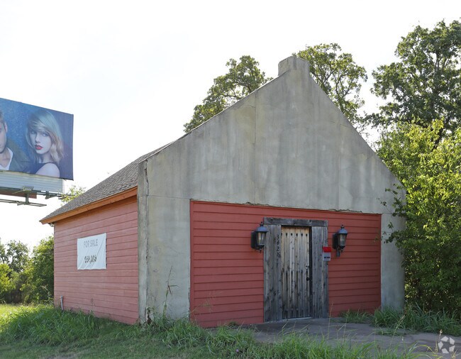
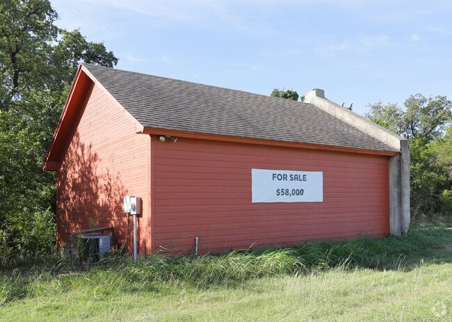
Property Record
3428 E Highway 67, Cleburne, TX 76031

Property Detail
3428 E Highway 67
Dallas-Fort Worth-Arlington, TX
ABST 895 TR 3A1 J G WARREN
126-0895-00032
JOHNSON
Farms
Texas
B and X Area of moderate flood hazard, usually the area between the limits of the 100-year and 500-year floods.
0.44 AC
2024
Southwest Outlying
2025
Dallas/Ft Worth
130303
NEARBY LISTINGS FOR SALE OR LEASE
DEMOGRAPHICS near 3428 E Highway 67
1 mile
3 mile
5 mile
2025 Total Population
4,062
11,917
32,558
2030 Population
4,611
13,570
37,165
Pop Growth 2025-2030
+ 13.52%
+ 13.87%
+ 14.15%
Average Age
36
38
39
2025 Total Households
1,352
4,046
11,049
HH Growth 2025-2030
+ 13.17%
+ 13.62%
+ 13.87%
Median Household Inc
$49,571
$58,686
$63,170
Avg Household Size
2.80
2.80
2.80
2025 Avg HH Vehicles
2.00
2.00
2.00
Median Home Value
$250,684
$269,622
$265,674
Median Year Built
1987
1988
1988
Nearby Places
Map Layers
Map Styles
 Street
 Aerial
Layers
 Traffic
 Biking
Places
Listings with unknown addresses are not visible on the map
- Restaurants
- Banks
- Shops
- Fitness
- Groceries
PUBLIC TRANSPORTATION
COMMUTER RAIL
Cleburne Amtrak Station (Texas Eagle - Amtrak)
Drive
Walk
Distance
Cleburne Amtrak Station (Texas Eagle - Amtrak)
10 min
6.0 mi
Freight Ports
Port of Shreveport
Drive
Walk
Distance
Port of Shreveport
254 min
234.7 mi
SALE & LEASE HISTORY
LISTING DATE
SALE/LEASE

Oct 10, 2016
For Sale
Nearby Properties
Address
Land Use
TOTAL SIZE
Lot Size
Zoning
Address
Land Use
TOTAL SIZE
Lot Size
Zoning
24.31 AC
Address
Land Use
TOTAL SIZE
Lot Size
Zoning
127,936 SF
41.41 AC
Address
Land Use
TOTAL SIZE
Lot Size
Zoning
45,750 SF
10.49 AC
Address
Land Use
TOTAL SIZE
Lot Size
Zoning
29,553 SF
7.93 AC
Address
Land Use
TOTAL SIZE
Lot Size
Zoning
34,500 SF
1.44 AC
Address
Land Use
TOTAL SIZE
Lot Size
Zoning
61,336 SF
10.30 AC
Address
Land Use
TOTAL SIZE
Lot Size
Zoning
43,000 SF
23.50 AC
Address
Land Use
TOTAL SIZE
Lot Size
Zoning
44,992 SF
18.14 AC
Address
Land Use
TOTAL SIZE
Lot Size
Zoning
47,300 SF
14.67 AC
Address
Land Use
TOTAL SIZE
Lot Size
Zoning
22,994 SF
2.92 AC
Address
Land Use
TOTAL SIZE
Lot Size
Zoning
52,100 SF
15 AC
Address
Land Use
TOTAL SIZE
Lot Size
Zoning
260 SF
185.34 AC
Address
Land Use
TOTAL SIZE
Lot Size
Zoning
34,342 SF
2.40 AC
Address
Land Use
TOTAL SIZE
Lot Size
Zoning
5,916 SF
5.78 AC
Address
Land Use
TOTAL SIZE
Lot Size
Zoning
181.46 AC
Address
Land Use
TOTAL SIZE
Lot Size
Zoning
4,070 SF
10.12 AC
Address
Land Use
TOTAL SIZE
Lot Size
Zoning
4,724 SF
15.43 AC
Address
Land Use
TOTAL SIZE
Lot Size
Zoning
27,100 SF
3.98 AC
Address
Land Use
TOTAL SIZE
Lot Size
Zoning
5.13 AC
Address
Land Use
TOTAL SIZE
Lot Size
Zoning
110,776 SF
15.16 AC
Address
Land Use
TOTAL SIZE
Lot Size
Zoning
55.03 AC
Address
Land Use
TOTAL SIZE
Lot Size
Zoning
54.95 AC
Address
Land Use
TOTAL SIZE
Lot Size
Zoning
13.49 AC
Address
Land Use
TOTAL SIZE
Lot Size
Zoning
Address
Land Use
TOTAL SIZE
Lot Size
Zoning
13,968 SF
17.34 AC
Address
Land Use
TOTAL SIZE
Lot Size
Zoning
63,704 SF
4.70 AC
Address
Land Use
TOTAL SIZE
Lot Size
Zoning
900 SF
131.66 AC
Address
Land Use
TOTAL SIZE
Lot Size
Zoning
42,878 SF
2.42 AC
Address
Land Use
TOTAL SIZE
Lot Size
Zoning
159.70 AC
Address
Land Use
TOTAL SIZE
Lot Size
Zoning
11,847 SF
3.20 AC
The World's #1 Commercial Real Estate Marketplace
Connect with us
© 2026 CoStar Group
The information above has been obtained from sources believed reliable. While we do not doubt its accuracy we have not verified it and make no guarantee, warranty or representation about it. It is your responsibility to independently confirm its accuracy and completeness. Any projections, opinions, assumptions, or estimates used are for example only and do not represent the current or future performance of the property. The value of this transaction to you depends on tax and other factors which should be evaluated by your tax, financial, and legal advisors. You and your advisors should conduct a careful, independent investigation of the property to determine to your satisfaction the suitability of the property for your needs.