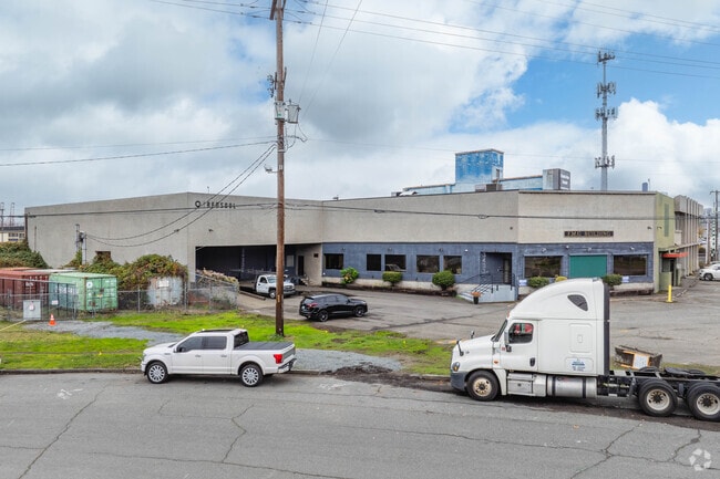
Property Record
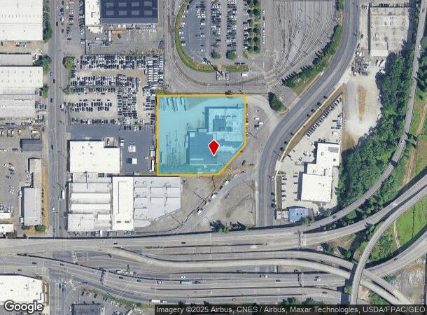
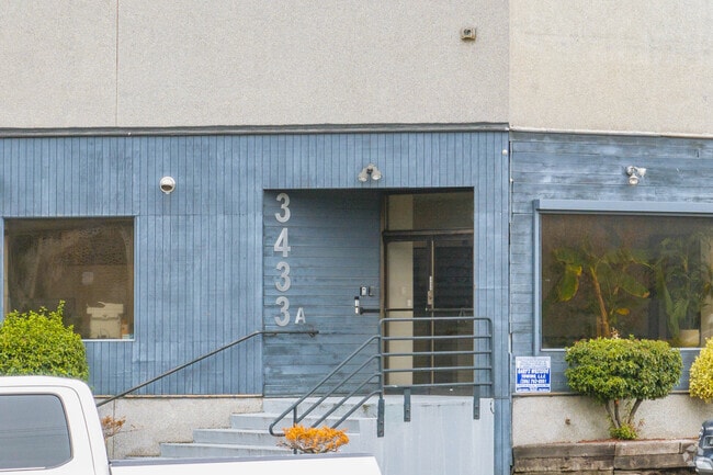
3433 Airport Way S, Seattle, WA 98134
NEARBY LISTINGS FOR SALE OR LEASE
Property Detail
3433 Airport Way S
Seattle-Tacoma-Bellevue, WA
Seattle Tide Lds Bl 01-376
766620-3850
SEATTLE TIDE LDS 14 LESS POR S OF LN BEG 4.5 FT NELY OF SE COR TH SWLY TO PT ON S LN 37 FT W OF SE COR BLK 256 & ALL 15 THRU 18
Warehouse
King
X
Washington
53033C0630G
14-18
2025
2.14 AC
2024
SoDo
009300
Seattle/Puget Sound
57,087 SF
DEMOGRAPHICS near 3433 Airport Way S
1 Mile
3 Mile
5 Mile
2024 Total Population
9,514
177,403
437,871
2029 Population
9,661
181,332
445,443
Pop Growth 2024-2029
+ 1.55%
+ 2.21%
+ 1.73%
Average Age
40
39
39
2024 Total Households
3,737
84,236
214,011
HH Growth 2024-2029
+ 1.39%
+ 2.40%
+ 1.82%
Median Household Inc
$105,922
$100,119
$110,505
Avg Household Size
2.40
1.90
1.90
2024 Avg HH Vehicles
2.00
1.00
1.00
Median Home Value
$769,553
$812,958
$851,161
Median Year Built
1950
1987
1982
Nearby Places
Map Layers
Map Styles
 Street
 Aerial
- Restaurants
- Banks
- Shops
- Fitness
- Groceries
PUBLIC TRANSPORTATION
TRANSIT/SUBWAY
St Light Rail & Sodo Station (Sb) (LINK to Sea-Tac - Sound Transit, Lynnwood - Angle Lake - Sound Transit)
DRIVE
WALK
Distance
St Light Rail & Sodo Station (Sb) (LINK to Sea-Tac - Sound Transit, Lynnwood - Angle Lake - Sound Transit)
2 min
15 min
0.8 mi
St Light Rail & Sodo Station (Nb) (LINK to Sea-Tac - Central Puget Sound Regional Transit Authority Rail (Link Light Rail/Sounder))
DRIVE
WALK
Distance
St Light Rail & Sodo Station (Nb) (LINK to Sea-Tac - Central Puget Sound Regional Transit Authority Rail (Link Light Rail/Sounder))
2 min
15 min
0.8 mi
Sodo (Central Link - Central Puget Sound Regional Transit Authority Rail (Link Light Rail/Sounder))
DRIVE
WALK
Distance
Sodo (Central Link - Central Puget Sound Regional Transit Authority Rail (Link Light Rail/Sounder))
3 min
16 min
0.8 mi
COMMUTER RAIL
King Street (Seattle) Station (Everett - Seattle - Sound Transit, Seattle - Tacoma/Lakewood - Sound Transit, Sounder South Line - Sound Transit)
DRIVE
WALK
Distance
King Street (Seattle) Station (Everett - Seattle - Sound Transit, Seattle - Tacoma/Lakewood - Sound Transit, Sounder South Line - Sound Transit)
6 min
2.1 mi
AIRPORT
Seattle-Tacoma International
DRIVE
WALK
Distance
Seattle-Tacoma International
21 min
12.2 mi
Seattle Paine Field International
DRIVE
WALK
Distance
Seattle Paine Field International
39 min
26.9 mi
Freight Ports
Port of Seattle
DRIVE
WALK
Distance
Port of Seattle
7 min
2.2 mi
SALE & LEASE HISTORY
LISTING DATE
SALE/LEASE

Oct 05, 2017
For Lease
Nearby Properties
Address
Land Use
TOTAL SIZE
Lot Size
Zoning
Address
Land Use
TOTAL SIZE
Lot Size
Zoning
2.84 AC
DMC 340/29
Address
Land Use
TOTAL SIZE
Lot Size
Zoning
793,990 SF
30.81 AC
UI U/85
Address
Land Use
TOTAL SIZE
Lot Size
Zoning
946,212 SF
1.58 AC
DMC 340/29
Address
Land Use
TOTAL SIZE
Lot Size
Zoning
992,925 SF
4.28 AC
MIO-240-HR
Address
Land Use
TOTAL SIZE
Lot Size
Zoning
1,526,621 SF
1.36 AC
DOC1 U/450
Address
Land Use
TOTAL SIZE
Lot Size
Zoning
1,062,251 SF
1.47 AC
DOC2 500/3
Address
Land Use
TOTAL SIZE
Lot Size
Zoning
763,898 SF
2.03 AC
DOC2 500/3
Address
Land Use
TOTAL SIZE
Lot Size
Zoning
1,137,666 SF
2.07 AC
DOC1 U/450
Address
Land Use
TOTAL SIZE
Lot Size
Zoning
7,930 SF
4.14 AC
MIO-240-HR
Address
Land Use
TOTAL SIZE
Lot Size
Zoning
6,379 SF
127.60 AC
MML U/85
Address
Land Use
TOTAL SIZE
Lot Size
Zoning
1,128,575 SF
1.30 AC
DOC1 U/450
Address
Land Use
TOTAL SIZE
Lot Size
Zoning
30,290 SF
564.80 AC
MML U/85
Address
Land Use
TOTAL SIZE
Lot Size
Zoning
861,221 SF
1.30 AC
DMC 340/29
Address
Land Use
TOTAL SIZE
Lot Size
Zoning
377,813 SF
1.65 AC
DOC2 500/3
Address
Land Use
TOTAL SIZE
Lot Size
Zoning
1,011,547 SF
0.35 AC
DOC1 U/450
Address
Land Use
TOTAL SIZE
Lot Size
Zoning
922,344 SF
1.33 AC
DRC 85-170
Address
Land Use
TOTAL SIZE
Lot Size
Zoning
412,000 SF
1.27 AC
DOC1 U/450
Address
Land Use
TOTAL SIZE
Lot Size
Zoning
943,610 SF
1.24 AC
DOC1 U/450
Address
Land Use
TOTAL SIZE
Lot Size
Zoning
540,360 SF
1.31 AC
DMC 340/29
Address
Land Use
TOTAL SIZE
Lot Size
Zoning
8,202 SF
1.30 AC
DOC1 U/450
Address
Land Use
TOTAL SIZE
Lot Size
Zoning
899,120 SF
0.62 AC
DOC1 U/450
Address
Land Use
TOTAL SIZE
Lot Size
Zoning
914,733 SF
1.41 AC
DOC1 U/450
Address
Land Use
TOTAL SIZE
Lot Size
Zoning
845,533 SF
0.98 AC
DOC1 U/450
Address
Land Use
TOTAL SIZE
Lot Size
Zoning
990,000 SF
0.33 AC
DOC1 U/450
Address
Land Use
TOTAL SIZE
Lot Size
Zoning
80,000 SF
97.30 AC
MML U/85
Address
Land Use
TOTAL SIZE
Lot Size
Zoning
362,344 SF
0.33 AC
MIO-240-HR
Address
Land Use
TOTAL SIZE
Lot Size
Zoning
726,103 SF
0.17 AC
MIO-240-HR
Address
Land Use
TOTAL SIZE
Lot Size
Zoning
38,770 SF
1.31 AC
DOC1 U/450
The World's #1 Commercial Real Estate Marketplace
Connect with us
© 2025 CoStar Group
The information above has been obtained from sources believed reliable. While we do not doubt its accuracy we have not verified it and make no guarantee, warranty or representation about it. It is your responsibility to independently confirm its accuracy and completeness. Any projections, opinions, assumptions, or estimates used are for example only and do not represent the current or future performance of the property. The value of this transaction to you depends on tax and other factors which should be evaluated by your tax, financial, and legal advisors. You and your advisors should conduct a careful, independent investigation of the property to determine to your satisfaction the suitability of the property for your needs.