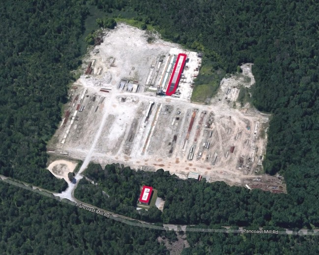
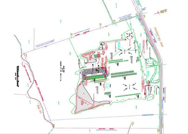
Property Record
344 Pancoast Mill Rd, Buena, NJ 08310

Property Detail
344 Pancoast Mill Rd
05-03801-0000-00013
ADDITIONAL LOTS: P/INCOME RET11/18/FACILITY NAME: BLDG VACANT
Industrialgeneral
Atlantic
FA1
New Jersey
A Areas with a 1% annual chance of flooding and a 26% chance of flooding over the life of a 30-year mortgage.
13
2024
81.88 AC
2025
Atlantic City/Hammonton
011202
Philadelphia
7,680 SF
Atlantic City-Hammonton, NJ
NEARBY LISTINGS FOR SALE OR LEASE
DEMOGRAPHICS near 344 Pancoast Mill Rd
1 mile
3 mile
5 mile
2025 Total Population
107
4,954
13,387
2030 Population
109
4,929
13,352
Pop Growth 2025-2030
+ 1.87%
(0.50%)
(0.26%)
Average Age
42
42
42
2025 Total Households
40
1,865
5,056
HH Growth 2025-2030
+ 2.50%
(0.97%)
(0.69%)
Median Household Inc
$67,500
$71,988
$82,154
Avg Household Size
2.60
2.60
2.60
2025 Avg HH Vehicles
2.00
2.00
2.00
Median Home Value
$228,571
$236,093
$245,347
Median Year Built
1964
1965
1968
Nearby Places
Map Layers
Map Styles
 Street
 Aerial
Layers
 Traffic
 Biking
Places
Listings with unknown addresses are not visible on the map
- Restaurants
- Banks
- Shops
- Fitness
- Groceries
PUBLIC TRANSPORTATION
AIRPORT
Atlantic City International
Drive
Walk
Distance
Atlantic City International
58 min
23.0 mi
Philadelphia International
Drive
Walk
Distance
Philadelphia International
69 min
46.1 mi
Freight Ports
Broadway Terminal - Pier 5
Drive
Walk
Distance
Broadway Terminal - Pier 5
53 min
37.6 mi
SALE & LEASE HISTORY
LISTING DATE
SALE/LEASE

May 24, 2021
For Sale
Dec 12, 2016
For Sale
Nearby Properties
Address
Land Use
TOTAL SIZE
Lot Size
Zoning
Address
Land Use
TOTAL SIZE
Lot Size
Zoning
286.98 AC
RDR1
Address
Land Use
TOTAL SIZE
Lot Size
Zoning
21.61 AC
PVR2
Address
Land Use
TOTAL SIZE
Lot Size
Zoning
11.44 AC
RA/B
Address
Land Use
TOTAL SIZE
Lot Size
Zoning
11.67 AC
Address
Land Use
TOTAL SIZE
Lot Size
Zoning
13.23 AC
Address
Land Use
TOTAL SIZE
Lot Size
Zoning
32.34 AC
Address
Land Use
TOTAL SIZE
Lot Size
Zoning
103.71 AC
NOTE
Address
Land Use
TOTAL SIZE
Lot Size
Zoning
6.16 AC
B1
Address
Land Use
TOTAL SIZE
Lot Size
Zoning
4.74 AC
Address
Land Use
TOTAL SIZE
Lot Size
Zoning
10.58 AC
Address
Land Use
TOTAL SIZE
Lot Size
Zoning
6.21 AC
Address
Land Use
TOTAL SIZE
Lot Size
Zoning
204.74 AC
FA1
Address
Land Use
TOTAL SIZE
Lot Size
Zoning
21.04 AC
FA1
Address
Land Use
TOTAL SIZE
Lot Size
Zoning
5.03 AC
B1
Address
Land Use
TOTAL SIZE
Lot Size
Zoning
Address
Land Use
TOTAL SIZE
Lot Size
Zoning
3.19 AC
Address
Land Use
TOTAL SIZE
Lot Size
Zoning
0.52 AC
R-2
Address
Land Use
TOTAL SIZE
Lot Size
Zoning
6.98 AC
FA1
Address
Land Use
TOTAL SIZE
Lot Size
Zoning
4,940 SF
1.97 AC
Address
Land Use
TOTAL SIZE
Lot Size
Zoning
3.85 AC
RDRI
Address
Land Use
TOTAL SIZE
Lot Size
Zoning
3,800 SF
0.73 AC
Address
Land Use
TOTAL SIZE
Lot Size
Zoning
14,000 SF
4.40 AC
Address
Land Use
TOTAL SIZE
Lot Size
Zoning
1,200 SF
0.46 AC
Address
Land Use
TOTAL SIZE
Lot Size
Zoning
1.76 AC
R-3
Address
Land Use
TOTAL SIZE
Lot Size
Zoning
3.90 AC
Address
Land Use
TOTAL SIZE
Lot Size
Zoning
27,500 SF
2.04 AC
Address
Land Use
TOTAL SIZE
Lot Size
Zoning
0.67 AC
PVRC
Address
Land Use
TOTAL SIZE
Lot Size
Zoning
2.62 AC
Address
Land Use
TOTAL SIZE
Lot Size
Zoning
1,528 SF
7.09 AC
The World's #1 Commercial Real Estate Marketplace
Connect with us
© 2026 CoStar Group
The information above has been obtained from sources believed reliable. While we do not doubt its accuracy we have not verified it and make no guarantee, warranty or representation about it. It is your responsibility to independently confirm its accuracy and completeness. Any projections, opinions, assumptions, or estimates used are for example only and do not represent the current or future performance of the property. The value of this transaction to you depends on tax and other factors which should be evaluated by your tax, financial, and legal advisors. You and your advisors should conduct a careful, independent investigation of the property to determine to your satisfaction the suitability of the property for your needs.