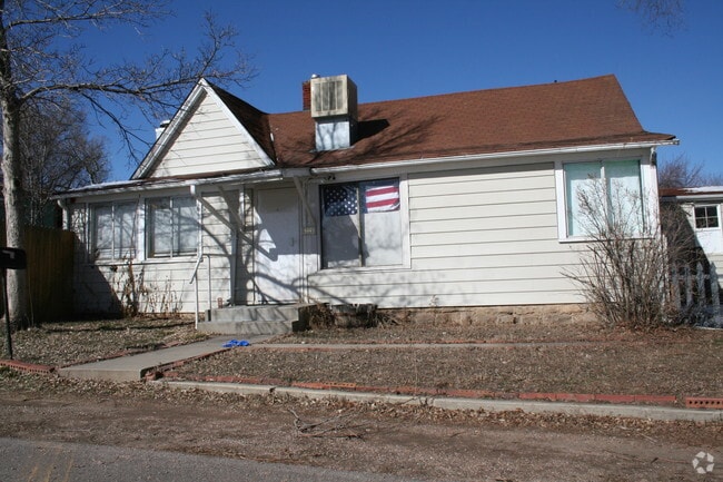
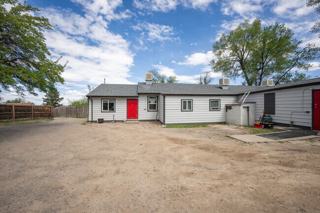
Property Record
3445 W Mansfield Ave, Denver, CO 80236


Save to a Folder
{{folder.Name}}
{{folder.ListingIds.length}} Properties
{{folder.ListingIds.length}} Property
Create a New Folder
Property Detail
3445 W Mansfield Ave
Denver-Aurora-Centennial, CO
SUBDIVISIONCD 054700 SUBDIVISIONNAME SHERIDAN BLOCK 002 LOT 010 LOTS 10-12 BLK 2 SHERIDAN
2077-05-2-27-005
Arapahoe
Apartment
Colorado
B and X Area of moderate flood hazard, usually the area between the limits of the 100-year and 500-year floods.
10
2025
0.50 AC
2026
Sheridan
005552
Denver
4,515 SF
NEARBY LISTINGS FOR SALE OR LEASE
DEMOGRAPHICS near 3445 W Mansfield Ave
1 mile
3 mile
5 mile
2025 Total Population
12,160
121,900
339,749
2030 Population
12,316
123,487
343,023
Pop Growth 2025-2030
+ 1.28%
+ 1.30%
+ 0.96%
Average Age
39
40
40
2025 Total Households
4,456
50,339
138,034
HH Growth 2025-2030
+ 1.32%
+ 1.40%
+ 1.08%
Median Household Inc
$77,995
$85,658
$91,940
Avg Household Size
2.60
2.30
2.40
2025 Avg HH Vehicles
2.00
2.00
2.00
Median Home Value
$473,426
$553,597
$640,391
Median Year Built
1971
1972
1973
Nearby Places
Map Layers
Map Styles
 Street
 Aerial
Layers
 Traffic
 Biking
Places
Listings with unknown addresses are not visible on the map
- Restaurants
- Banks
- Shops
- Fitness
- Groceries
PUBLIC TRANSPORTATION
COMMUTER RAIL
Union Station: Lodo-Coors Field-16Th Street Mall (C Line - Denver Regional Transportation District Light Rail (TheRide), E Line - Denver Regional Transportation District Light Rail (TheRide), W Line - Denver Regional Transportation District Light Rail (TheRide))
Drive
Walk
Distance
Union Station: Lodo-Coors Field-16Th Street Mall (C Line - Denver Regional Transportation District Light Rail (TheRide), E Line - Denver Regional Transportation District Light Rail (TheRide), W Line - Denver Regional Transportation District Light Rail (TheRide))
17 min
9.9 mi
AIRPORT
Denver International
Drive
Walk
Distance
Denver International
46 min
33.4 mi
Freight Ports
Tulsa Port Of Catoosa
Drive
Walk
Distance
Tulsa Port Of Catoosa
743 min
716.2 mi
SALE & LEASE HISTORY
LISTING DATE
SALE/LEASE

Jun 18, 2024
For Sale
Jul 13, 2023
For Sale
Aug 01, 2023
For Sale
Apr 07, 2025
For Sale
Nearby Properties
Address
Land Use
TOTAL SIZE
Lot Size
Zoning
Address
Land Use
TOTAL SIZE
Lot Size
Zoning
1,360,162 SF
6.27 AC
Address
Land Use
TOTAL SIZE
Lot Size
Zoning
172,644 SF
8.77 AC
Address
Land Use
TOTAL SIZE
Lot Size
Zoning
665,722 SF
615.85 AC
OS-B
Address
Land Use
TOTAL SIZE
Lot Size
Zoning
330,776 SF
48.11 AC
CMP-H2
Address
Land Use
TOTAL SIZE
Lot Size
Zoning
248,291 SF
128.77 AC
CMP-H2
Address
Land Use
TOTAL SIZE
Lot Size
Zoning
251,583 SF
38.03 AC
Address
Land Use
TOTAL SIZE
Lot Size
Zoning
381 SF
66.05 AC
I-B
Address
Land Use
TOTAL SIZE
Lot Size
Zoning
214,192 SF
0.03 AC
Address
Land Use
TOTAL SIZE
Lot Size
Zoning
304,560 SF
23.94 AC
S-SU-F
Address
Land Use
TOTAL SIZE
Lot Size
Zoning
14,029 SF
23.97 AC
Address
Land Use
TOTAL SIZE
Lot Size
Zoning
298,752 SF
73.96 AC
Address
Land Use
TOTAL SIZE
Lot Size
Zoning
208,529 SF
34.81 AC
R-5
Address
Land Use
TOTAL SIZE
Lot Size
Zoning
33,500 SF
53.33 AC
Address
Land Use
TOTAL SIZE
Lot Size
Zoning
368,527 SF
18.71 AC
S-SU-D
Address
Land Use
TOTAL SIZE
Lot Size
Zoning
110,016 SF
1.29 AC
Address
Land Use
TOTAL SIZE
Lot Size
Zoning
501,310 SF
12.56 AC
Address
Land Use
TOTAL SIZE
Lot Size
Zoning
47.24 AC
Address
Land Use
TOTAL SIZE
Lot Size
Zoning
139,858 SF
2.36 AC
Address
Land Use
TOTAL SIZE
Lot Size
Zoning
70,662 SF
0.13 AC
I-A
Address
Land Use
TOTAL SIZE
Lot Size
Zoning
107,159 SF
26.40 AC
Address
Land Use
TOTAL SIZE
Lot Size
Zoning
221,025 SF
8.45 AC
PUD
Address
Land Use
TOTAL SIZE
Lot Size
Zoning
68,082 SF
3.09 AC
S-MU
Address
Land Use
TOTAL SIZE
Lot Size
Zoning
137,526 SF
11.35 AC
Address
Land Use
TOTAL SIZE
Lot Size
Zoning
356,896 SF
12.90 AC
LPD-R
Address
Land Use
TOTAL SIZE
Lot Size
Zoning
39.44 AC
Address
Land Use
TOTAL SIZE
Lot Size
Zoning
446,582 SF
19.24 AC
Address
Land Use
TOTAL SIZE
Lot Size
Zoning
229,830 SF
11.33 AC
Address
Land Use
TOTAL SIZE
Lot Size
Zoning
10,260 SF
49.33 AC
CMP-H2
Address
Land Use
TOTAL SIZE
Lot Size
Zoning
205,949 SF
16.46 AC
S-SU-F
Address
Land Use
TOTAL SIZE
Lot Size
Zoning
239,795 SF
12.56 AC
I-A
The World's #1 Commercial Real Estate Marketplace
Connect with us
© 2026 CoStar Group
The information above has been obtained from sources believed reliable. While we do not doubt its accuracy we have not verified it and make no guarantee, warranty or representation about it. It is your responsibility to independently confirm its accuracy and completeness. Any projections, opinions, assumptions, or estimates used are for example only and do not represent the current or future performance of the property. The value of this transaction to you depends on tax and other factors which should be evaluated by your tax, financial, and legal advisors. You and your advisors should conduct a careful, independent investigation of the property to determine to your satisfaction the suitability of the property for your needs.