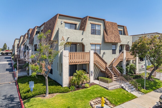
Property Record
345 K St, Chula Vista, CA 91911


Save to a Folder
{{folder.Name}}
{{folder.ListingIds.length}} Properties
{{folder.ListingIds.length}} Property
Create a New Folder
Property Detail
345 K St
573-320-46
QSEC 139 LOT 31 (EX NELY 300 FT) TR 000505
Multifamilydwelling
San Diego
CO
California
B and X Area of moderate flood hazard, usually the area between the limits of the 100-year and 500-year floods.
31
2025
2.13 AC
2026
Downtown Chula Vista
013000
San Diego
9,325 SF
San Diego-Chula Vista-Carlsbad, CA
NEARBY LISTINGS FOR SALE OR LEASE
DEMOGRAPHICS near 345 K St
1 mile
3 mile
5 mile
2025 Total Population
31,194
157,592
421,434
2030 Population
31,164
157,366
421,284
Pop Growth 2025-2030
(0.10%)
(0.14%)
(0.04%)
Average Age
38
39
39
2025 Total Households
10,098
49,275
126,999
HH Growth 2025-2030
(0.25%)
(0.30%)
(0.16%)
Median Household Inc
$73,551
$78,915
$87,741
Avg Household Size
3.00
3.10
3.20
2025 Avg HH Vehicles
2.00
2.00
2.00
Median Home Value
$711,487
$677,744
$717,201
Median Year Built
1962
1968
1975
Nearby Places
Map Layers
Map Styles
 Street
 Aerial
Layers
 Traffic
 Biking
Places
Listings with unknown addresses are not visible on the map
- Restaurants
- Banks
- Shops
- Fitness
- Groceries
PUBLIC TRANSPORTATION
AIRPORT
San Diego International
Drive
Walk
Distance
San Diego International
19 min
13.2 mi
Freight Ports
Port of San Diego
Drive
Walk
Distance
Port of San Diego
14 min
9.2 mi
Nearby Properties
Address
Land Use
TOTAL SIZE
Lot Size
Zoning
Address
Land Use
TOTAL SIZE
Lot Size
Zoning
19.28 AC
60
Address
Land Use
TOTAL SIZE
Lot Size
Zoning
17.38 AC
UNZ
Address
Land Use
TOTAL SIZE
Lot Size
Zoning
9,999 SF
11.42 AC
CP
Address
Land Use
TOTAL SIZE
Lot Size
Zoning
9,999 SF
6.55 AC
MXD-2
Address
Land Use
TOTAL SIZE
Lot Size
Zoning
9,999 SF
8.79 AC
R3
Address
Land Use
TOTAL SIZE
Lot Size
Zoning
24.70 AC
C-6
Address
Land Use
TOTAL SIZE
Lot Size
Zoning
9,999 SF
9.44 AC
PC
Address
Land Use
TOTAL SIZE
Lot Size
Zoning
25.35 AC
UC-7
Address
Land Use
TOTAL SIZE
Lot Size
Zoning
9,999 SF
15 AC
UC-14
Address
Land Use
TOTAL SIZE
Lot Size
Zoning
9,999 SF
9.84 AC
C
Address
Land Use
TOTAL SIZE
Lot Size
Zoning
24.06 AC
R3
Address
Land Use
TOTAL SIZE
Lot Size
Zoning
8.96 AC
UC-4
Address
Land Use
TOTAL SIZE
Lot Size
Zoning
9,999 SF
6.03 AC
R3
Address
Land Use
TOTAL SIZE
Lot Size
Zoning
9,999 SF
2.81 AC
IP
Address
Land Use
TOTAL SIZE
Lot Size
Zoning
9,999 SF
1.05 AC
C-1
Address
Land Use
TOTAL SIZE
Lot Size
Zoning
34,200 SF
1.38 AC
CCPD-R
Address
Land Use
TOTAL SIZE
Lot Size
Zoning
10 SF
2.41 AC
MXC-1
Address
Land Use
TOTAL SIZE
Lot Size
Zoning
9,999 SF
6.85 AC
IL
Address
Land Use
TOTAL SIZE
Lot Size
Zoning
9,999 SF
4.70 AC
R3
Address
Land Use
TOTAL SIZE
Lot Size
Zoning
9,999 SF
7.96 AC
PC9RM
Address
Land Use
TOTAL SIZE
Lot Size
Zoning
6,410 SF
UNZ
Address
Land Use
TOTAL SIZE
Lot Size
Zoning
7,397 SF
4.10 AC
R3
Address
Land Use
TOTAL SIZE
Lot Size
Zoning
9,999 SF
7.52 AC
CTP
Address
Land Use
TOTAL SIZE
Lot Size
Zoning
9,999 SF
5.28 AC
CC-4-5
Address
Land Use
TOTAL SIZE
Lot Size
Zoning
9,999 SF
1.43 AC
UC-2
Address
Land Use
TOTAL SIZE
Lot Size
Zoning
9,999 SF
1.88 AC
UC-2
Address
Land Use
TOTAL SIZE
Lot Size
Zoning
9,999 SF
1.43 AC
UC-2
Address
Land Use
TOTAL SIZE
Lot Size
Zoning
6,797 SF
1.23 AC
C-6
Address
Land Use
TOTAL SIZE
Lot Size
Zoning
9,999 SF
4.71 AC
R3
Address
Land Use
TOTAL SIZE
Lot Size
Zoning
5,996 SF
8.34 AC
PC
The World's #1 Commercial Real Estate Marketplace
Connect with us
© 2026 CoStar Group
The information above has been obtained from sources believed reliable. While we do not doubt its accuracy we have not verified it and make no guarantee, warranty or representation about it. It is your responsibility to independently confirm its accuracy and completeness. Any projections, opinions, assumptions, or estimates used are for example only and do not represent the current or future performance of the property. The value of this transaction to you depends on tax and other factors which should be evaluated by your tax, financial, and legal advisors. You and your advisors should conduct a careful, independent investigation of the property to determine to your satisfaction the suitability of the property for your needs.