Property Record
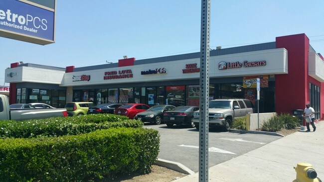
3470 E Cesar E Chavez Ave, Los Angeles, CA 90063


Property Detail
3470 E Cesar E Chavez Ave
5232-008-035
M R 24-25-28 (EX OF ST) LOT 30 AND (EX OF ST AND ALLEY) LOT 31 BLK 20
Storemultistory
Los Angeles
LCC3*
California
B and X Area of moderate flood hazard, usually the area between the limits of the 100-year and 500-year floods.
30,31
2024
0.31 AC
2025
Southeast Los Angeles
531101
Los Angeles
6,782 SF
Los Angeles-Long Beach-Glendale, CA
NEARBY LISTINGS FOR SALE OR LEASE
DEMOGRAPHICS near 3470 E Cesar E Chavez Ave
1 mile
3 mile
5 mile
2025 Total Population
53,788
257,734
814,657
2030 Population
52,646
252,711
802,966
Pop Growth 2025-2030
(2.12%)
(1.95%)
(1.44%)
Average Age
37
38
39
2025 Total Households
14,215
72,363
262,404
HH Growth 2025-2030
(2.39%)
(2.16%)
(1.29%)
Median Household Inc
$69,071
$68,350
$67,938
Avg Household Size
3.70
3.30
2.90
2025 Avg HH Vehicles
2.00
2.00
2.00
Median Home Value
$703,673
$747,188
$778,211
Median Year Built
1947
1950
1958
Nearby Places
Map Layers
Map Styles
 Street
 Aerial
Layers
 Traffic
 Biking
Places
Listings with unknown addresses are not visible on the map
- Restaurants
- Banks
- Shops
- Fitness
- Groceries
PUBLIC TRANSPORTATION
TRANSIT/SUBWAY
Indiana (Gold Line - Los Angeles County Metropolitan Transportation Authority (Metro))
Drive
Walk
Distance
Indiana (Gold Line - Los Angeles County Metropolitan Transportation Authority (Metro))
2 min
11 min
0.6 mi
COMMUTER RAIL
Union Station (91 Line - Southern California Regional Rail Authority (Metrolink), Antelope Valley Line - Southern California Regional Rail Authority (Metrolink), Orange County Line - Southern California Regional Rail Authority (Metrolink), Riverside Line - Southern California Regional Rail Authority (Metrolink), San Bernardino Line - Southern California Regional Rail Authority (Metrolink), Ventura County Line - Southern California Regional Rail Authority (Metrolink))
Drive
Walk
Distance
Union Station (91 Line - Southern California Regional Rail Authority (Metrolink), Antelope Valley Line - Southern California Regional Rail Authority (Metrolink), Orange County Line - Southern California Regional Rail Authority (Metrolink), Riverside Line - Southern California Regional Rail Authority (Metrolink), San Bernardino Line - Southern California Regional Rail Authority (Metrolink), Ventura County Line - Southern California Regional Rail Authority (Metrolink))
11 min
3.1 mi
Drive
Walk
Distance
7 min
3.2 mi
AIRPORT
Bob Hope
Drive
Walk
Distance
Bob Hope
26 min
18.3 mi
Los Angeles International
Drive
Walk
Distance
Los Angeles International
31 min
18.9 mi
Long Beach (Daugherty Field)
Drive
Walk
Distance
Long Beach (Daugherty Field)
28 min
19.0 mi
SALE & LEASE HISTORY
LISTING DATE
SALE/LEASE

Sep 25, 2016
For Lease
Nearby Properties
Address
Land Use
TOTAL SIZE
Lot Size
Zoning
Address
Land Use
TOTAL SIZE
Lot Size
Zoning
2,697,158 SF
20.18 AC
LAM2
Address
Land Use
TOTAL SIZE
Lot Size
Zoning
635,233 SF
12.02 AC
LAR5
Address
Land Use
TOTAL SIZE
Lot Size
Zoning
513,825 SF
4.28 AC
LAC2
Address
Land Use
TOTAL SIZE
Lot Size
Zoning
444,139 SF
3.63 AC
LAM3
Address
Land Use
TOTAL SIZE
Lot Size
Zoning
534,225 SF
Address
Land Use
TOTAL SIZE
Lot Size
Zoning
479,272 SF
16.14 AC
LAM3
Address
Land Use
TOTAL SIZE
Lot Size
Zoning
1,088,170 SF
15.98 AC
LAM3
Address
Land Use
TOTAL SIZE
Lot Size
Zoning
535,949 SF
5.85 AC
LAM3
Address
Land Use
TOTAL SIZE
Lot Size
Zoning
327,061 SF
2.18 AC
LAM3
Address
Land Use
TOTAL SIZE
Lot Size
Zoning
322,080 SF
2.85 AC
LAC2
Address
Land Use
TOTAL SIZE
Lot Size
Zoning
182,700 SF
8.29 AC
LAM3
Address
Land Use
TOTAL SIZE
Lot Size
Zoning
328,737 SF
7.92 AC
LAC2
Address
Land Use
TOTAL SIZE
Lot Size
Zoning
642,160 SF
8.26 AC
LAADP
Address
Land Use
TOTAL SIZE
Lot Size
Zoning
368,058 SF
2.65 AC
LAUC (CA)
Address
Land Use
TOTAL SIZE
Lot Size
Zoning
354,299 SF
2.18 AC
LAC2
Address
Land Use
TOTAL SIZE
Lot Size
Zoning
150,608 SF
0.88 AC
LAC2
Address
Land Use
TOTAL SIZE
Lot Size
Zoning
397,866 SF
3.51 AC
LAM3
Address
Land Use
TOTAL SIZE
Lot Size
Zoning
527,173 SF
12.36 AC
CMM2*
Address
Land Use
TOTAL SIZE
Lot Size
Zoning
276,452 SF
1.21 AC
LAM3
Address
Land Use
TOTAL SIZE
Lot Size
Zoning
218,680 SF
1.82 AC
LAR5
Address
Land Use
TOTAL SIZE
Lot Size
Zoning
252,559 SF
2.87 AC
LAC2
Address
Land Use
TOTAL SIZE
Lot Size
Zoning
188,319 SF
11.25 AC
VEM&MS1*
Address
Land Use
TOTAL SIZE
Lot Size
Zoning
318,388 SF
11.07 AC
LAM2
Address
Land Use
TOTAL SIZE
Lot Size
Zoning
104,676 SF
4.32 AC
LAM3
Address
Land Use
TOTAL SIZE
Lot Size
Zoning
195,526 SF
2.81 AC
LAADP
Address
Land Use
TOTAL SIZE
Lot Size
Zoning
285,189 SF
1.58 AC
LAC2
Address
Land Use
TOTAL SIZE
Lot Size
Zoning
172,072 SF
1.82 AC
LAC2
Address
Land Use
TOTAL SIZE
Lot Size
Zoning
260,714 SF
9.99 AC
VEM*
Address
Land Use
TOTAL SIZE
Lot Size
Zoning
7.02 AC
LAM3
Address
Land Use
TOTAL SIZE
Lot Size
Zoning
75,589 SF
0.98 AC
LAC2
The World's #1 Commercial Real Estate Marketplace
Connect with us
© 2026 CoStar Group
The information above has been obtained from sources believed reliable. While we do not doubt its accuracy we have not verified it and make no guarantee, warranty or representation about it. It is your responsibility to independently confirm its accuracy and completeness. Any projections, opinions, assumptions, or estimates used are for example only and do not represent the current or future performance of the property. The value of this transaction to you depends on tax and other factors which should be evaluated by your tax, financial, and legal advisors. You and your advisors should conduct a careful, independent investigation of the property to determine to your satisfaction the suitability of the property for your needs.