Property Record
350 Main St, Durham, CT 06422
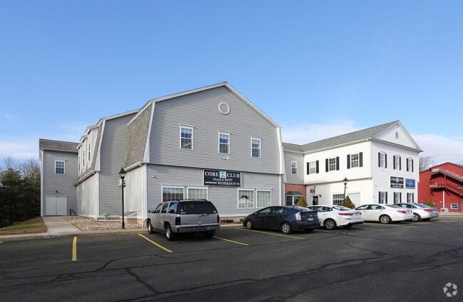

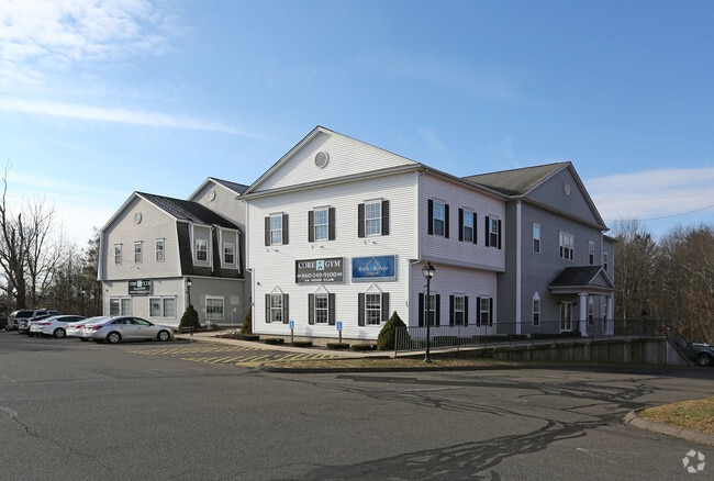
Property Detail
350 Main St
A0001602
Lower Ct River Vly
Commercialnec
Connecticut
COMMER
2.16 AC
B and X Area of moderate flood hazard, usually the area between the limits of the 100-year and 500-year floods.
NW Middlesex/Middletown
2024
Hartford
2025
Hartford-West Hartford-East Hartford, CT
585100
NEARBY LISTINGS FOR SALE OR LEASE
-
-
View all Durham listings for lease on LoopNet.com
DEMOGRAPHICS near 350 Main St
1 mile
3 mile
5 mile
2025 Total Population
1,403
9,223
37,904
2030 Population
1,399
9,203
38,085
Pop Growth 2025-2030
(0.29%)
(0.22%)
+ 0.48%
Average Age
44
44
43
2025 Total Households
569
3,671
15,023
HH Growth 2025-2030
(0.35%)
(0.19%)
+ 0.43%
Median Household Inc
$100,248
$123,058
$97,606
Avg Household Size
2.50
2.50
2.30
2025 Avg HH Vehicles
2.00
2.00
2.00
Median Home Value
$356,410
$383,333
$348,190
Median Year Built
1968
1975
1971
Nearby Places
Map Layers
Map Styles
 Street
 Aerial
Transit
 Traffic
 Biking
Places
Listings with unknown addresses are not visible on the map
- Restaurants
- Banks
- Shops
- Fitness
- Groceries
PUBLIC TRANSPORTATION
COMMUTER RAIL
Drive
Walk
Distance
18 min
9.2 mi
Drive
Walk
Distance
17 min
9.4 mi
AIRPORT
Tweed/New Haven
Drive
Walk
Distance
Tweed/New Haven
39 min
24.8 mi
Bradley International
Drive
Walk
Distance
Bradley International
63 min
39.1 mi
Freight Ports
Port of New Haven
Drive
Walk
Distance
Port of New Haven
35 min
22.5 mi
SALE & LEASE HISTORY
LISTING DATE
SALE/LEASE

Jan 30, 2023
For Lease
Nearby Properties
Address
Land Use
TOTAL SIZE
Lot Size
Zoning
Address
Land Use
TOTAL SIZE
Lot Size
Zoning
54,264 SF
15 AC
PRD
Address
Land Use
TOTAL SIZE
Lot Size
Zoning
124,940 SF
49.46 AC
FARM -
Address
Land Use
TOTAL SIZE
Lot Size
Zoning
20.60 AC
I-4
Address
Land Use
TOTAL SIZE
Lot Size
Zoning
49,299 SF
19.98 AC
IPD1
Address
Land Use
TOTAL SIZE
Lot Size
Zoning
40,938 SF
14.53 AC
FARM -
Address
Land Use
TOTAL SIZE
Lot Size
Zoning
32.52 AC
AG2
Address
Land Use
TOTAL SIZE
Lot Size
Zoning
62,967 SF
9.40 AC
MAIN S
Address
Land Use
TOTAL SIZE
Lot Size
Zoning
59,557 SF
12.24 AC
I-4
Address
Land Use
TOTAL SIZE
Lot Size
Zoning
30.51 AC
MAIN S
Address
Land Use
TOTAL SIZE
Lot Size
Zoning
32,375 SF
18.94 AC
FARM -
Address
Land Use
TOTAL SIZE
Lot Size
Zoning
267.22 AC
RU40
Address
Land Use
TOTAL SIZE
Lot Size
Zoning
93,345 SF
50.98 AC
FARM -
Address
Land Use
TOTAL SIZE
Lot Size
Zoning
36.01 AC
I-4
Address
Land Use
TOTAL SIZE
Lot Size
Zoning
3.27 AC
HEAVY
Address
Land Use
TOTAL SIZE
Lot Size
Zoning
12.62 AC
HEAVY
Address
Land Use
TOTAL SIZE
Lot Size
Zoning
264 AC
HEAVY
Address
Land Use
TOTAL SIZE
Lot Size
Zoning
15,661 SF
1.07 AC
HD2
Address
Land Use
TOTAL SIZE
Lot Size
Zoning
6.40 AC
I-4
Address
Land Use
TOTAL SIZE
Lot Size
Zoning
18.08 AC
MAIN S
Address
Land Use
TOTAL SIZE
Lot Size
Zoning
1.98 AC
R-30
Address
Land Use
TOTAL SIZE
Lot Size
Zoning
17,049 SF
4.01 AC
HD2
Address
Land Use
TOTAL SIZE
Lot Size
Zoning
36,885 SF
5.41 AC
I-4
Address
Land Use
TOTAL SIZE
Lot Size
Zoning
3,000 SF
9.50 AC
I-4
Address
Land Use
TOTAL SIZE
Lot Size
Zoning
14.03 AC
HEAVY
Address
Land Use
TOTAL SIZE
Lot Size
Zoning
2.95 AC
I-4
Address
Land Use
TOTAL SIZE
Lot Size
Zoning
3,675 SF
3.42 AC
MAIN S
Address
Land Use
TOTAL SIZE
Lot Size
Zoning
4,184 SF
0.90 AC
COMMER
Address
Land Use
TOTAL SIZE
Lot Size
Zoning
2,190 SF
98.78 AC
MD
Address
Land Use
TOTAL SIZE
Lot Size
Zoning
6,476 SF
7.73 AC
MD
Address
Land Use
TOTAL SIZE
Lot Size
Zoning
20.90 AC
FARM -
The World's #1 Commercial Real Estate Marketplace
Connect with us
© 2026 CoStar Group
The information above has been obtained from sources believed reliable. While we do not doubt its accuracy we have not verified it and make no guarantee, warranty or representation about it. It is your responsibility to independently confirm its accuracy and completeness. Any projections, opinions, assumptions, or estimates used are for example only and do not represent the current or future performance of the property. The value of this transaction to you depends on tax and other factors which should be evaluated by your tax, financial, and legal advisors. You and your advisors should conduct a careful, independent investigation of the property to determine to your satisfaction the suitability of the property for your needs.