Property Record
350 N Dobson Rd, Mesa, AZ 85201

Property Detail
350 N Dobson Rd
403-08-064J
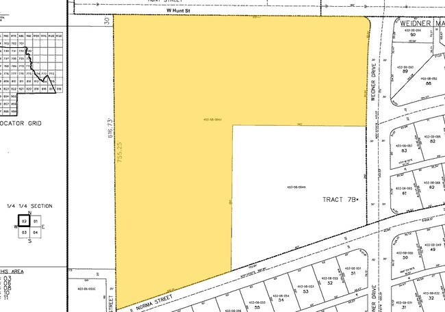
TH PT TRACT 7-B IN NW4 SE4 SEC 36 DAF BEG NW COR TR 7-B TH S 755.25F TH N 70D 03M E 657.14F TH N 523.69F TH W 619.77F TO POB EX TH PT DAF BEG AT NW COR TR 7-B TH S 755.25F TH N 70D 03M E 657.14F TO TPOB TH N 262F TH W 340F TH S 393F TH N 70D 03M E 36
Residentialacreage
MARICOPA
R-7
Arizona
C and X Area of minimal flood hazard, usually depicted on FIRMs as above the 500-year flood level.
6.53 AC
2025
Southwest Outlying
2025
Phoenix
421303
Phoenix-Mesa-Chandler, AZ
NEARBY LISTINGS FOR SALE OR LEASE
-
-
No Photo
-
-
-
-
View all Mesa listings for sale on LoopNet.com
DEMOGRAPHICS near 350 N Dobson Rd
1 mile
3 mile
5 mile
2025 Total Population
1,059
1,348
1,368
2030 Population
995
1,272
1,292
Pop Growth 2025-2030
(6.04%)
(5.64%)
(5.56%)
Average Age
36
36
36
2025 Total Households
339
424
430
HH Growth 2025-2030
(6.19%)
(5.66%)
(5.58%)
Median Household Inc
$49,396
$49,614
$49,624
Avg Household Size
3.20
3.20
3.20
2025 Avg HH Vehicles
2.00
2.00
2.00
Median Home Value
$156,372
$152,232
$152,212
Median Year Built
1976
1976
1976
Nearby Places
Map Layers
Map Styles
 Street
 Aerial
Transit
 Traffic
 Biking
Places
Listings with unknown addresses are not visible on the map
- Restaurants
- Banks
- Shops
- Fitness
- Groceries
Nearby Properties
Address
Land Use
TOTAL SIZE
Lot Size
Zoning
Address
Land Use
TOTAL SIZE
Lot Size
Zoning
183,940 SF
40.95 AC
R-7
Address
Land Use
TOTAL SIZE
Lot Size
Zoning
176,889 SF
34.89 AC
I-2
Address
Land Use
TOTAL SIZE
Lot Size
Zoning
400 AC
SFOZ
Address
Land Use
TOTAL SIZE
Lot Size
Zoning
8,502 SF
1.67 AC
M-M
Address
Land Use
TOTAL SIZE
Lot Size
Zoning
24,405 SF
20.26 AC
I-2
Address
Land Use
TOTAL SIZE
Lot Size
Zoning
311.81 AC
M-M
Address
Land Use
TOTAL SIZE
Lot Size
Zoning
2,068 SF
7.76 AC
R-7
Address
Land Use
TOTAL SIZE
Lot Size
Zoning
99,777 SF
19.10 AC
I-2
Address
Land Use
TOTAL SIZE
Lot Size
Zoning
6,058 SF
3.55 AC
C-C
Address
Land Use
TOTAL SIZE
Lot Size
Zoning
5,891 SF
1.84 AC
C-C
Address
Land Use
TOTAL SIZE
Lot Size
Zoning
4,073 SF
5.32 AC
C-C
Address
Land Use
TOTAL SIZE
Lot Size
Zoning
25,841 SF
2.34 AC
C-C
Address
Land Use
TOTAL SIZE
Lot Size
Zoning
43,618 SF
93.59 AC
I-2
Address
Land Use
TOTAL SIZE
Lot Size
Zoning
16,139 SF
3.55 AC
C-C
Address
Land Use
TOTAL SIZE
Lot Size
Zoning
5,529 SF
0.62 AC
C-C
Address
Land Use
TOTAL SIZE
Lot Size
Zoning
2,948 SF
2.38 AC
C-C
Address
Land Use
TOTAL SIZE
Lot Size
Zoning
34,206 SF
6.23 AC
M-H
Address
Land Use
TOTAL SIZE
Lot Size
Zoning
9,504 SF
5.65 AC
I-1
Address
Land Use
TOTAL SIZE
Lot Size
Zoning
2,742 SF
0.46 AC
C-C
Address
Land Use
TOTAL SIZE
Lot Size
Zoning
15,506 SF
1.14 AC
C-C
Address
Land Use
TOTAL SIZE
Lot Size
Zoning
8,000 SF
1.30 AC
C-C
Address
Land Use
TOTAL SIZE
Lot Size
Zoning
8,880 SF
1.37 AC
C-C
Address
Land Use
TOTAL SIZE
Lot Size
Zoning
2,870 SF
23.78 AC
I-2
Address
Land Use
TOTAL SIZE
Lot Size
Zoning
10,440 SF
0.27 AC
C-C
Address
Land Use
TOTAL SIZE
Lot Size
Zoning
19,865 SF
2 AC
M-H
Address
Land Use
TOTAL SIZE
Lot Size
Zoning
3,598 SF
4.30 AC
C-C
Address
Land Use
TOTAL SIZE
Lot Size
Zoning
4,662 SF
6.68 AC
I-1
The World's #1 Commercial Real Estate Marketplace
Connect with us
© 2026 CoStar Group
The information above has been obtained from sources believed reliable. While we do not doubt its accuracy we have not verified it and make no guarantee, warranty or representation about it. It is your responsibility to independently confirm its accuracy and completeness. Any projections, opinions, assumptions, or estimates used are for example only and do not represent the current or future performance of the property. The value of this transaction to you depends on tax and other factors which should be evaluated by your tax, financial, and legal advisors. You and your advisors should conduct a careful, independent investigation of the property to determine to your satisfaction the suitability of the property for your needs.