Property Record
3504 Rochambeau Ave, Bronx, NY 10467
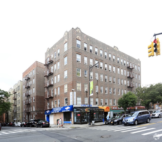

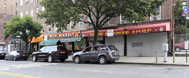
Property Detail
3504 Rochambeau Ave
03328-0064
Bronx
Apartment
New York
R7-1
64
B and X Area of moderate flood hazard, usually the area between the limits of the 100-year and 500-year floods.
0.32 AC
2024
Norwood
2025
Westchester/So Connecticut
043101
New York-Jersey City-White Plains, NY-NJ
60,301 SF
NEARBY LISTINGS FOR SALE OR LEASE
DEMOGRAPHICS near 3504 Rochambeau Ave
1 mile
3 mile
5 mile
2025 Total Population
109,738
835,797
1,775,898
2030 Population
108,617
819,502
1,753,291
Pop Growth 2025-2030
(1.02%)
(1.95%)
(1.27%)
Average Age
39
39
39
2025 Total Households
40,058
300,227
638,915
HH Growth 2025-2030
(1.32%)
(2.16%)
(1.42%)
Median Household Inc
$51,199
$55,047
$53,633
Avg Household Size
2.60
2.60
2.60
2025 Avg HH Vehicles
.00
1.00
1.00
Median Home Value
$221,184
$503,912
$531,699
Median Year Built
1948
1950
1951
Nearby Places
Map Layers
Map Styles
 Street
 Aerial
Transit
 Traffic
 Biking
Places
Listings with unknown addresses are not visible on the map
- Restaurants
- Banks
- Shops
- Fitness
- Groceries
PUBLIC TRANSPORTATION
TRANSIT/SUBWAY
Woodlawn (4 - New York MTA Subway (The Subway))
Drive
Walk
Distance
Woodlawn (4 - New York MTA Subway (The Subway))
1 min
7 min
0.4 mi
Williams Bridge Station (Harlem Line - Metro-North Commuter Railroad Company (Metro-North))
Drive
Walk
Distance
Williams Bridge Station (Harlem Line - Metro-North Commuter Railroad Company (Metro-North))
1 min
10 min
0.5 mi
205 Street-Norwood (D - New York MTA Subway (The Subway))
Drive
Walk
Distance
205 Street-Norwood (D - New York MTA Subway (The Subway))
2 min
11 min
0.6 mi
Mosholu Parkway (4 - New York MTA Subway (The Subway))
Drive
Walk
Distance
Mosholu Parkway (4 - New York MTA Subway (The Subway))
2 min
11 min
0.6 mi
Gun Hill Road (2,5 Line) (2 - New York MTA Subway (The Subway), 5 - New York MTA Subway (The Subway))
Drive
Walk
Distance
Gun Hill Road (2,5 Line) (2 - New York MTA Subway (The Subway), 5 - New York MTA Subway (The Subway))
2 min
15 min
0.8 mi
COMMUTER RAIL
Williams Bridge Station (Harlem Line - Metro-North Commuter Railroad Company (Metro-North))
Drive
Walk
Distance
Williams Bridge Station (Harlem Line - Metro-North Commuter Railroad Company (Metro-North))
1 min
10 min
0.5 mi
Botanical Garden Station (Harlem Line - Metro-North Commuter Railroad Company (Metro-North))
Drive
Walk
Distance
Botanical Garden Station (Harlem Line - Metro-North Commuter Railroad Company (Metro-North))
4 min
1.5 mi
AIRPORT
LaGuardia
Drive
Walk
Distance
LaGuardia
24 min
12.4 mi
John F Kennedy International
Drive
Walk
Distance
John F Kennedy International
34 min
20.8 mi
Westchester County
Drive
Walk
Distance
Westchester County
33 min
21.3 mi
Freight Ports
NY - Red Hook Container Terminal
Drive
Walk
Distance
NY - Red Hook Container Terminal
37 min
20.6 mi
SALE & LEASE HISTORY
LISTING DATE
SALE/LEASE

Jun 07, 2023
For Lease
Feb 12, 2018
For Lease
Nearby Properties
Address
Land Use
TOTAL SIZE
Lot Size
Zoning
Address
Land Use
TOTAL SIZE
Lot Size
Zoning
1,299,700 SF
29.82 AC
R6
Address
Land Use
TOTAL SIZE
Lot Size
Zoning
550,000 SF
8.75 AC
M1-1
Address
Land Use
TOTAL SIZE
Lot Size
Zoning
1,743,584 SF
77.87 AC
R6
Address
Land Use
TOTAL SIZE
Lot Size
Zoning
1,427,393 SF
39.94 AC
R4
Address
Land Use
TOTAL SIZE
Lot Size
Zoning
481,172 SF
205.58 AC
PARK
Address
Land Use
TOTAL SIZE
Lot Size
Zoning
1,132,500 SF
62.44 AC
R6
Address
Land Use
TOTAL SIZE
Lot Size
Zoning
895,256 SF
8.32 AC
R7-1
Address
Land Use
TOTAL SIZE
Lot Size
Zoning
1,237,424 SF
21.25 AC
R6
Address
Land Use
TOTAL SIZE
Lot Size
Zoning
485,484 SF
39.63 AC
R5
Address
Land Use
TOTAL SIZE
Lot Size
Zoning
204,200 SF
1.68 AC
R7-1
Address
Land Use
TOTAL SIZE
Lot Size
Zoning
667,405 SF
5.51 AC
R6
Address
Land Use
TOTAL SIZE
Lot Size
Zoning
390,750 SF
265 AC
PARK
Address
Land Use
TOTAL SIZE
Lot Size
Zoning
617,567 SF
3.19 AC
R7-1
Address
Land Use
TOTAL SIZE
Lot Size
Zoning
537,208 SF
4.73 AC
C4-3
Address
Land Use
TOTAL SIZE
Lot Size
Zoning
545,388 SF
29.07 AC
C4-3
Address
Land Use
TOTAL SIZE
Lot Size
Zoning
631,237 SF
30.93 AC
R5
Address
Land Use
TOTAL SIZE
Lot Size
Zoning
707,353 SF
29.34 AC
R6
Address
Land Use
TOTAL SIZE
Lot Size
Zoning
851,821 SF
7.95 AC
R4
Address
Land Use
TOTAL SIZE
Lot Size
Zoning
259.87 AC
PARK
Address
Land Use
TOTAL SIZE
Lot Size
Zoning
393,924 SF
4.50 AC
R7-2
Address
Land Use
TOTAL SIZE
Lot Size
Zoning
224,037 SF
0.82 AC
C45X
Address
Land Use
TOTAL SIZE
Lot Size
Zoning
269,100 SF
1.63 AC
R4
Address
Land Use
TOTAL SIZE
Lot Size
Zoning
87,000 SF
455.70 AC
PARK
Address
Land Use
TOTAL SIZE
Lot Size
Zoning
361,354 SF
C4-2
Address
Land Use
TOTAL SIZE
Lot Size
Zoning
450,784 SF
42.36 AC
R4
Address
Land Use
TOTAL SIZE
Lot Size
Zoning
18,445 SF
510.83 AC
PARK
Address
Land Use
TOTAL SIZE
Lot Size
Zoning
251,884 SF
21.53 AC
R6
Address
Land Use
TOTAL SIZE
Lot Size
Zoning
601,260 SF
3.27 AC
R4
Address
Land Use
TOTAL SIZE
Lot Size
Zoning
1,028,976 SF
23.03 AC
R5
Address
Land Use
TOTAL SIZE
Lot Size
Zoning
406,549 SF
3.22 AC
C4-4
The World's #1 Commercial Real Estate Marketplace
Connect with us
© 2026 CoStar Group
The information above has been obtained from sources believed reliable. While we do not doubt its accuracy we have not verified it and make no guarantee, warranty or representation about it. It is your responsibility to independently confirm its accuracy and completeness. Any projections, opinions, assumptions, or estimates used are for example only and do not represent the current or future performance of the property. The value of this transaction to you depends on tax and other factors which should be evaluated by your tax, financial, and legal advisors. You and your advisors should conduct a careful, independent investigation of the property to determine to your satisfaction the suitability of the property for your needs.