Property Record
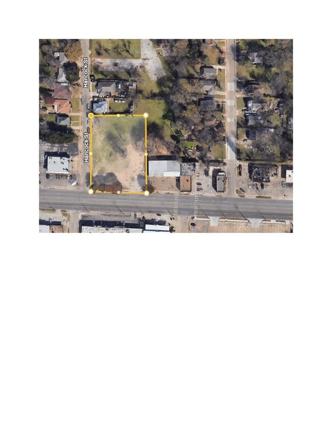
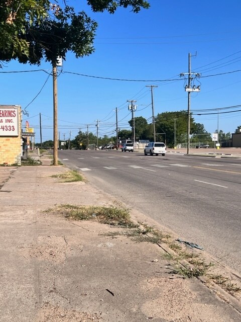
3514 Hancock St, Dallas, TX 75210

Property Detail
3514 Hancock St
Dallas-Fort Worth-Arlington, TX
BLK 4456 TR 6 ACS 0.0587 CALC INT201700260512 DD08242017 CO-DC 4456 000 00600 1004456 000
00000323797000000
DALLAS
Commercialacreage
Texas
Z59
6
B and X Area of moderate flood hazard, usually the area between the limits of the 100-year and 500-year floods.
0.06 AC
2024
Southeast Dallas
2025
Dallas/Ft Worth
020800
NEARBY LISTINGS FOR SALE OR LEASE
DEMOGRAPHICS near 3514 Hancock St
1 mile
3 mile
5 mile
2025 Total Population
12,967
83,455
352,619
2030 Population
13,636
87,173
367,153
Pop Growth 2025-2030
+ 5.16%
+ 4.46%
+ 4.12%
Average Age
36
37
36
2025 Total Households
4,395
30,561
149,301
HH Growth 2025-2030
+ 5.19%
+ 4.88%
+ 4.54%
Median Household Inc
$35,232
$61,047
$73,028
Avg Household Size
2.80
2.60
2.30
2025 Avg HH Vehicles
1.00
2.00
2.00
Median Home Value
$173,453
$237,107
$327,518
Median Year Built
1972
1969
1982
Nearby Places
Map Layers
Map Styles
 Street
 Aerial
Layers
 Traffic
 Biking
Places
Listings with unknown addresses are not visible on the map
- Restaurants
- Banks
- Shops
- Fitness
- Groceries
PUBLIC TRANSPORTATION
TRANSIT/SUBWAY
Hatcher (Green Line - Dallas Area Rapid Transit (DART))
Drive
Walk
Distance
Hatcher (Green Line - Dallas Area Rapid Transit (DART))
2 min
10 min
0.5 mi
COMMUTER RAIL
Drive
Walk
Distance
11 min
5.3 mi
Drive
Walk
Distance
14 min
7.2 mi
AIRPORT
Dallas Love Field
Drive
Walk
Distance
Dallas Love Field
19 min
9.3 mi
Dallas-Fort Worth International
Drive
Walk
Distance
Dallas-Fort Worth International
35 min
24.7 mi
SALE & LEASE HISTORY
LISTING DATE
SALE/LEASE

Dec 11, 2023
For Sale
Apr 02, 2026
For Sale
Nearby Properties
Address
Land Use
TOTAL SIZE
Lot Size
Zoning
Address
Land Use
TOTAL SIZE
Lot Size
Zoning
3,398,834 SF
13.45 AC
Z151
Address
Land Use
TOTAL SIZE
Lot Size
Zoning
659,884 SF
5.77 AC
Z151
Address
Land Use
TOTAL SIZE
Lot Size
Zoning
593,031 SF
4.66 AC
Address
Land Use
TOTAL SIZE
Lot Size
Zoning
644,416 SF
1.26 AC
Z239
Address
Land Use
TOTAL SIZE
Lot Size
Zoning
661,775 SF
12.55 AC
Z151
Address
Land Use
TOTAL SIZE
Lot Size
Zoning
529,666 SF
1.21 AC
Z239
Address
Land Use
TOTAL SIZE
Lot Size
Zoning
479,689 SF
0.78 AC
Z239
Address
Land Use
TOTAL SIZE
Lot Size
Zoning
452,834 SF
2.76 AC
Z21
Address
Land Use
TOTAL SIZE
Lot Size
Zoning
307,756 SF
0.11 AC
Z151
Address
Land Use
TOTAL SIZE
Lot Size
Zoning
458,874 SF
4.71 AC
Z239
Address
Land Use
TOTAL SIZE
Lot Size
Zoning
521,757 SF
3.85 AC
Z239
Address
Land Use
TOTAL SIZE
Lot Size
Zoning
339,086 SF
4.35 AC
Z163
Address
Land Use
TOTAL SIZE
Lot Size
Zoning
213,616 SF
16.31 AC
Z239
Address
Land Use
TOTAL SIZE
Lot Size
Zoning
467,743 SF
2.56 AC
Z239
Address
Land Use
TOTAL SIZE
Lot Size
Zoning
563,339 SF
7.10 AC
Z21
Address
Land Use
TOTAL SIZE
Lot Size
Zoning
505,910 SF
6.30 AC
Z21
Address
Land Use
TOTAL SIZE
Lot Size
Zoning
457,920 SF
3.20 AC
Z21
Address
Land Use
TOTAL SIZE
Lot Size
Zoning
384,943 SF
7.14 AC
Z239
Address
Land Use
TOTAL SIZE
Lot Size
Zoning
694,550 SF
7.81 AC
Address
Land Use
TOTAL SIZE
Lot Size
Zoning
239,221 SF
11.01 AC
Z164
Address
Land Use
TOTAL SIZE
Lot Size
Zoning
300,789 SF
1.32 AC
Z239
Address
Land Use
TOTAL SIZE
Lot Size
Zoning
716,678 SF
4.22 AC
Z179
Address
Land Use
TOTAL SIZE
Lot Size
Zoning
320,240 SF
1.93 AC
Z21
Address
Land Use
TOTAL SIZE
Lot Size
Zoning
322,205 SF
1.22 AC
Z239
Address
Land Use
TOTAL SIZE
Lot Size
Zoning
141,588 SF
20.33 AC
Z46
Address
Land Use
TOTAL SIZE
Lot Size
Zoning
265,650 SF
1 AC
Z239
Address
Land Use
TOTAL SIZE
Lot Size
Zoning
556,046 SF
2.23 AC
Z239
Address
Land Use
TOTAL SIZE
Lot Size
Zoning
26,437 SF
18.67 AC
Z239
Address
Land Use
TOTAL SIZE
Lot Size
Zoning
293,947 SF
1.75 AC
MU3
Address
Land Use
TOTAL SIZE
Lot Size
Zoning
110,327 SF
4.12 AC
Z239
The World's #1 Commercial Real Estate Marketplace
Connect with us
© 2026 CoStar Group
The information above has been obtained from sources believed reliable. While we do not doubt its accuracy we have not verified it and make no guarantee, warranty or representation about it. It is your responsibility to independently confirm its accuracy and completeness. Any projections, opinions, assumptions, or estimates used are for example only and do not represent the current or future performance of the property. The value of this transaction to you depends on tax and other factors which should be evaluated by your tax, financial, and legal advisors. You and your advisors should conduct a careful, independent investigation of the property to determine to your satisfaction the suitability of the property for your needs.