Property Record
3517 Warner Blvd, Burbank, CA 91505
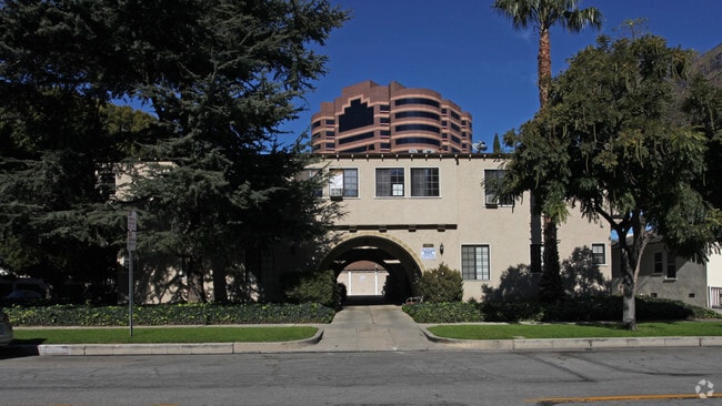


Property Detail
3517 Warner Blvd
2485-024-030
LOT COM AT NW COR OF LOT 26 TR # 9523 TH N 66 5605 E 109.15 FT TH S 22 59 40 E 135 FT TH SW ON NW LINE OF WARNER BLVD AND NW ON NE LINE OF CORDOVA ST TO BEG PART OF LOT 5 TRACT # 7553 AND ALL OF LOT 26 TRACT # 9523
Multifamilydwelling
Los Angeles
BUR4*
California
B and X Area of moderate flood hazard, usually the area between the limits of the 100-year and 500-year floods.
26
2025
0.35 AC
2025
Media Center
311601
Los Angeles
8,116 SF
Los Angeles-Long Beach-Glendale, CA
NEARBY LISTINGS FOR SALE OR LEASE
DEMOGRAPHICS near 3517 Warner Blvd
1 mile
3 mile
5 mile
2025 Total Population
16,365
172,065
644,744
2030 Population
16,209
171,216
643,577
Pop Growth 2025-2030
(0.95%)
(0.49%)
(0.18%)
Average Age
41
41
41
2025 Total Households
7,906
77,480
287,398
HH Growth 2025-2030
(1.34%)
(0.69%)
(0.30%)
Median Household Inc
$108,572
$92,880
$85,089
Avg Household Size
2.00
2.20
2.20
2025 Avg HH Vehicles
2.00
2.00
1.00
Median Home Value
$1,094,803
$1,054,238
$1,049,096
Median Year Built
1964
1966
1965
Nearby Places
Map Layers
Map Styles
 Street
 Aerial
Layers
 Traffic
 Biking
Places
Listings with unknown addresses are not visible on the map
- Restaurants
- Banks
- Shops
- Fitness
- Groceries
PUBLIC TRANSPORTATION
COMMUTER RAIL
Downtown Burbank (Antelope Valley Line - Southern California Regional Rail Authority (Metrolink), Ventura County Line - Southern California Regional Rail Authority (Metrolink))
Drive
Walk
Distance
Downtown Burbank (Antelope Valley Line - Southern California Regional Rail Authority (Metrolink), Ventura County Line - Southern California Regional Rail Authority (Metrolink))
6 min
2.6 mi
Burbank-Bob Hope Airport (Ventura County Line - Southern California Regional Rail Authority (Metrolink))
Drive
Walk
Distance
Burbank-Bob Hope Airport (Ventura County Line - Southern California Regional Rail Authority (Metrolink))
8 min
3.6 mi
AIRPORT
Bob Hope
Drive
Walk
Distance
Bob Hope
12 min
5.1 mi
Los Angeles International
Drive
Walk
Distance
Los Angeles International
36 min
25.8 mi
Long Beach (Daugherty Field)
Drive
Walk
Distance
Long Beach (Daugherty Field)
45 min
33.4 mi
Freight Ports
Port of Long Beach
Drive
Walk
Distance
Port of Long Beach
48 min
35.2 mi
Nearby Properties
Address
Land Use
TOTAL SIZE
Lot Size
Zoning
Address
Land Use
TOTAL SIZE
Lot Size
Zoning
152,217 SF
70.95 AC
BUM1*
Address
Land Use
TOTAL SIZE
Lot Size
Zoning
735,900 SF
34.87 AC
BUPD*
Address
Land Use
TOTAL SIZE
Lot Size
Zoning
65,532 SF
67.90 AC
LAM11/2*
Address
Land Use
TOTAL SIZE
Lot Size
Zoning
21,585 SF
61.40 AC
LAM11/2*
Address
Land Use
TOTAL SIZE
Lot Size
Zoning
1,314,760 SF
33.64 AC
LAM11/2*
Address
Land Use
TOTAL SIZE
Lot Size
Zoning
207,766 SF
42.81 AC
BUM1*
Address
Land Use
TOTAL SIZE
Lot Size
Zoning
1,426,324 SF
5.96 AC
LAC2
Address
Land Use
TOTAL SIZE
Lot Size
Zoning
12,827 SF
130.37 AC
LAM11/2*
Address
Land Use
TOTAL SIZE
Lot Size
Zoning
616,662 SF
19.66 AC
BUM1*
Address
Land Use
TOTAL SIZE
Lot Size
Zoning
986,983 SF
105.50 AC
LARE40
Address
Land Use
TOTAL SIZE
Lot Size
Zoning
397,477 SF
2.75 AC
BUR4
Address
Land Use
TOTAL SIZE
Lot Size
Zoning
690,600 SF
6.57 AC
LACM
Address
Land Use
TOTAL SIZE
Lot Size
Zoning
475,433 SF
19.35 AC
BUM1*
Address
Land Use
TOTAL SIZE
Lot Size
Zoning
489,466 SF
2.90 AC
BUM1
Address
Land Use
TOTAL SIZE
Lot Size
Zoning
452,048 SF
21.58 AC
BCCM
Address
Land Use
TOTAL SIZE
Lot Size
Zoning
696,128 SF
2.42 AC
BUC3*
Address
Land Use
TOTAL SIZE
Lot Size
Zoning
43,558 SF
30.11 AC
BUMI-C2*
Address
Land Use
TOTAL SIZE
Lot Size
Zoning
1,328,547 SF
39.36 AC
BUPD
Address
Land Use
TOTAL SIZE
Lot Size
Zoning
432,232 SF
7.17 AC
BUM2
Address
Land Use
TOTAL SIZE
Lot Size
Zoning
219,607 SF
1.51 AC
BUR4
Address
Land Use
TOTAL SIZE
Lot Size
Zoning
380,017 SF
Address
Land Use
TOTAL SIZE
Lot Size
Zoning
354,068 SF
2.72 AC
LAR4
Address
Land Use
TOTAL SIZE
Lot Size
Zoning
336,041 SF
2.05 AC
LAC4
Address
Land Use
TOTAL SIZE
Lot Size
Zoning
440,774 SF
2.20 AC
BUR4*
Address
Land Use
TOTAL SIZE
Lot Size
Zoning
462,896 SF
1.38 AC
BUR4*
Address
Land Use
TOTAL SIZE
Lot Size
Zoning
362,863 SF
1.82 AC
BUMZ
Address
Land Use
TOTAL SIZE
Lot Size
Zoning
380,276 SF
7.18 AC
LAR4
Address
Land Use
TOTAL SIZE
Lot Size
Zoning
232,965 SF
3.78 AC
LAC4
Address
Land Use
TOTAL SIZE
Lot Size
Zoning
388,171 SF
2.42 AC
LAC4
Address
Land Use
TOTAL SIZE
Lot Size
Zoning
433,745 SF
8.59 AC
LAC2
The World's #1 Commercial Real Estate Marketplace
Connect with us
© 2026 CoStar Group
The information above has been obtained from sources believed reliable. While we do not doubt its accuracy we have not verified it and make no guarantee, warranty or representation about it. It is your responsibility to independently confirm its accuracy and completeness. Any projections, opinions, assumptions, or estimates used are for example only and do not represent the current or future performance of the property. The value of this transaction to you depends on tax and other factors which should be evaluated by your tax, financial, and legal advisors. You and your advisors should conduct a careful, independent investigation of the property to determine to your satisfaction the suitability of the property for your needs.