Property Record
353 Providence Mine Rd, Nevada City, CA 95959


NEARBY LISTINGS FOR SALE OR LEASE
Property Detail
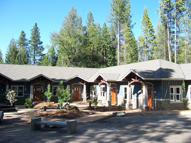
353 Providence Mine Rd
005-190-058-000
Liberty Hill Condos
Commercialcondominium
UNIT 3 LIBERTY HILL CONDOS
X
Nevada
06057C0375E
California
2024
0.04 AC
2025
California North Rural Area
000802
Other Market Areas
1,728 SF
Truckee-Grass Valley, CA
DEMOGRAPHICS near 353 Providence Mine Rd
1 Mile
3 Mile
5 Mile
2024 Total Population
2,621
19,472
33,601
2029 Population
2,617
19,343
33,261
Pop Growth 2024-2029
(0.15%)
(0.66%)
(1.01%)
Average Age
50
49
48
2024 Total Households
1,214
8,439
14,530
HH Growth 2024-2029
(0.16%)
(0.69%)
(1.05%)
Median Household Inc
$61,084
$58,484
$62,535
Avg Household Size
2.10
2.10
2.20
2024 Avg HH Vehicles
2.00
2.00
2.00
Median Home Value
$516,756
$536,307
$499,024
Median Year Built
1971
1978
1977
Nearby Places
Map Layers
Map Styles
 Street
 Aerial
- Restaurants
- Banks
- Shops
- Fitness
- Groceries
SALE & LEASE HISTORY
LISTING DATE
SALE/LEASE

Sep 25, 2016
For Lease
Sep 25, 2016
For Lease
Feb 13, 2019
For Sale
Aug 28, 2019
For Lease
Aug 19, 2024
For Lease
Aug 05, 2017
For Sale
Nearby Properties
Address
Land Use
TOTAL SIZE
Lot Size
Zoning
Address
Land Use
TOTAL SIZE
Lot Size
Zoning
Address
Land Use
TOTAL SIZE
Lot Size
Zoning
145,522 SF
6.39 AC
Address
Land Use
TOTAL SIZE
Lot Size
Zoning
74,019 SF
4.20 AC
Address
Land Use
TOTAL SIZE
Lot Size
Zoning
45,263 SF
2.61 AC
Address
Land Use
TOTAL SIZE
Lot Size
Zoning
45,427 SF
4.06 AC
Address
Land Use
TOTAL SIZE
Lot Size
Zoning
26,556 SF
0.49 AC
Address
Land Use
TOTAL SIZE
Lot Size
Zoning
28,125 SF
7.12 AC
Address
Land Use
TOTAL SIZE
Lot Size
Zoning
14,550 SF
1.95 AC
Address
Land Use
TOTAL SIZE
Lot Size
Zoning
48,000 SF
3.52 AC
Address
Land Use
TOTAL SIZE
Lot Size
Zoning
Address
Land Use
TOTAL SIZE
Lot Size
Zoning
7.84 AC
Address
Land Use
TOTAL SIZE
Lot Size
Zoning
21,505 SF
4.13 AC
Address
Land Use
TOTAL SIZE
Lot Size
Zoning
14,504 SF
2.21 AC
Address
Land Use
TOTAL SIZE
Lot Size
Zoning
19,072 SF
2.93 AC
Address
Land Use
TOTAL SIZE
Lot Size
Zoning
87,696 SF
4.80 AC
Address
Land Use
TOTAL SIZE
Lot Size
Zoning
40,969 SF
3.48 AC
Address
Land Use
TOTAL SIZE
Lot Size
Zoning
47,976 SF
4.52 AC
Address
Land Use
TOTAL SIZE
Lot Size
Zoning
41,130 SF
2.29 AC
Address
Land Use
TOTAL SIZE
Lot Size
Zoning
22,155 SF
2.77 AC
Address
Land Use
TOTAL SIZE
Lot Size
Zoning
33,642 SF
0.95 AC
Address
Land Use
TOTAL SIZE
Lot Size
Zoning
Address
Land Use
TOTAL SIZE
Lot Size
Zoning
26,218 SF
3.37 AC
Address
Land Use
TOTAL SIZE
Lot Size
Zoning
17,210 SF
2.29 AC
Address
Land Use
TOTAL SIZE
Lot Size
Zoning
33,450 SF
2.13 AC
M1-SP
Address
Land Use
TOTAL SIZE
Lot Size
Zoning
49,672 SF
6.32 AC
Address
Land Use
TOTAL SIZE
Lot Size
Zoning
9,961 SF
2.13 AC
Address
Land Use
TOTAL SIZE
Lot Size
Zoning
69,711 SF
6.63 AC
Address
Land Use
TOTAL SIZE
Lot Size
Zoning
Address
Land Use
TOTAL SIZE
Lot Size
Zoning
32,000 SF
2.26 AC
The World's #1 Commercial Real Estate Marketplace
Connect with us
© 2026 CoStar Group
The information above has been obtained from sources believed reliable. While we do not doubt its accuracy we have not verified it and make no guarantee, warranty or representation about it. It is your responsibility to independently confirm its accuracy and completeness. Any projections, opinions, assumptions, or estimates used are for example only and do not represent the current or future performance of the property. The value of this transaction to you depends on tax and other factors which should be evaluated by your tax, financial, and legal advisors. You and your advisors should conduct a careful, independent investigation of the property to determine to your satisfaction the suitability of the property for your needs.