Property Record
353 S 1100 W, Provo, UT 84601
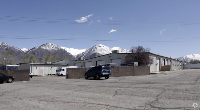

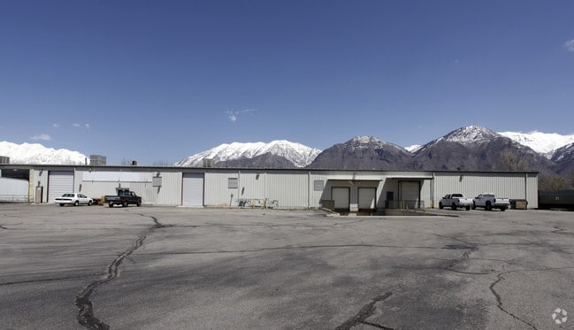
Property Detail
353 S 1100 W
Provo-Orem-Lehi, UT
LOT 2, PLAT A, DONCASTER SUBDV. AREA 3.980 AC.
37-261-0002
UTAH
Lightindustrial
Utah
2024
2
2025
3.98 AC
002300
Utah County
88,781 SF
Salt Lake City
NEARBY LISTINGS FOR SALE OR LEASE
DEMOGRAPHICS near 353 S 1100 W
1 mile
3 mile
5 mile
2025 Total Population
20,926
124,331
189,105
2030 Population
22,791
136,869
208,189
Pop Growth 2025-2030
+ 8.91%
+ 10.08%
+ 10.09%
Average Age
31
29
30
2025 Total Households
7,092
38,499
57,935
HH Growth 2025-2030
+ 9.72%
+ 11.32%
+ 11.20%
Median Household Inc
$62,404
$61,641
$71,512
Avg Household Size
2.90
2.90
3.00
2025 Avg HH Vehicles
2.00
2.00
2.00
Median Home Value
$395,668
$479,294
$513,188
Median Year Built
1982
1987
1989
Nearby Places
Map Layers
Map Styles
 Street
 Aerial
Layers
 Traffic
 Biking
Places
Listings with unknown addresses are not visible on the map
- Restaurants
- Banks
- Shops
- Fitness
- Groceries
PUBLIC TRANSPORTATION
COMMUTER RAIL
Provo Amtrak (California Zephyr - Amtrak)
Drive
Walk
Distance
Provo Amtrak (California Zephyr - Amtrak)
3 min
18 min
1.0 mi
Provo Central Station (FrontRunner - Utah Transit Authority (UTA))
Drive
Walk
Distance
Provo Central Station (FrontRunner - Utah Transit Authority (UTA))
4 min
1.2 mi
AIRPORT
Provo Municipal
Drive
Walk
Distance
Provo Municipal
9 min
3.8 mi
Freight Ports
Port of Stockton
Drive
Walk
Distance
Port of Stockton
756 min
738.4 mi
Nearby Properties
Address
Land Use
TOTAL SIZE
Lot Size
Zoning
Address
Land Use
TOTAL SIZE
Lot Size
Zoning
1,744,846 SF
19.25 AC
Address
Land Use
TOTAL SIZE
Lot Size
Zoning
442,598 SF
22.94 AC
Address
Land Use
TOTAL SIZE
Lot Size
Zoning
347,829 SF
5.26 AC
Address
Land Use
TOTAL SIZE
Lot Size
Zoning
222,763 SF
10.71 AC
Address
Land Use
TOTAL SIZE
Lot Size
Zoning
366,509 SF
2.83 AC
Address
Land Use
TOTAL SIZE
Lot Size
Zoning
138,990 SF
2.87 AC
Address
Land Use
TOTAL SIZE
Lot Size
Zoning
297,467 SF
16.87 AC
Address
Land Use
TOTAL SIZE
Lot Size
Zoning
371,881 SF
4.91 AC
Address
Land Use
TOTAL SIZE
Lot Size
Zoning
323,674 SF
13.81 AC
Address
Land Use
TOTAL SIZE
Lot Size
Zoning
245,657 SF
5.60 AC
Address
Land Use
TOTAL SIZE
Lot Size
Zoning
107,840 SF
0.98 AC
Address
Land Use
TOTAL SIZE
Lot Size
Zoning
222,848 SF
11.14 AC
Address
Land Use
TOTAL SIZE
Lot Size
Zoning
266,387 SF
1.76 AC
Address
Land Use
TOTAL SIZE
Lot Size
Zoning
174,883 SF
17.42 AC
Address
Land Use
TOTAL SIZE
Lot Size
Zoning
269,652 SF
3.65 AC
Address
Land Use
TOTAL SIZE
Lot Size
Zoning
155,726 SF
13.64 AC
Address
Land Use
TOTAL SIZE
Lot Size
Zoning
300,810 SF
7.32 AC
Address
Land Use
TOTAL SIZE
Lot Size
Zoning
208,492 SF
12.49 AC
Address
Land Use
TOTAL SIZE
Lot Size
Zoning
176,127 SF
9.29 AC
Address
Land Use
TOTAL SIZE
Lot Size
Zoning
233,451 SF
1.73 AC
Address
Land Use
TOTAL SIZE
Lot Size
Zoning
206,778 SF
5.11 AC
Address
Land Use
TOTAL SIZE
Lot Size
Zoning
9,326 SF
5.19 AC
Address
Land Use
TOTAL SIZE
Lot Size
Zoning
124,986 SF
8.67 AC
Address
Land Use
TOTAL SIZE
Lot Size
Zoning
195,248 SF
13.20 AC
Address
Land Use
TOTAL SIZE
Lot Size
Zoning
170,907 SF
1.18 AC
Address
Land Use
TOTAL SIZE
Lot Size
Zoning
265,411 SF
19.28 AC
Address
Land Use
TOTAL SIZE
Lot Size
Zoning
106,191 SF
2.26 AC
Address
Land Use
TOTAL SIZE
Lot Size
Zoning
213,512 SF
1.24 AC
Address
Land Use
TOTAL SIZE
Lot Size
Zoning
170,636 SF
1.21 AC
Address
Land Use
TOTAL SIZE
Lot Size
Zoning
67,093 SF
2.94 AC
The World's #1 Commercial Real Estate Marketplace
Connect with us
© 2026 CoStar Group
The information above has been obtained from sources believed reliable. While we do not doubt its accuracy we have not verified it and make no guarantee, warranty or representation about it. It is your responsibility to independently confirm its accuracy and completeness. Any projections, opinions, assumptions, or estimates used are for example only and do not represent the current or future performance of the property. The value of this transaction to you depends on tax and other factors which should be evaluated by your tax, financial, and legal advisors. You and your advisors should conduct a careful, independent investigation of the property to determine to your satisfaction the suitability of the property for your needs.