Property Record
4125 Schlipf Rd, Katy, TX 77493
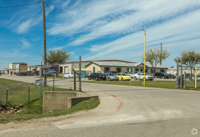

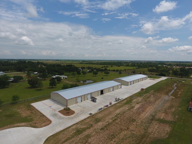
Property Detail
4125 Schlipf Rd
188663
ABS A337300 A-373 FRED EULE TRACT 2-20 ACRES 10.062
Commercialnec
Waller
B and X Area of moderate flood hazard, usually the area between the limits of the 100-year and 500-year floods.
Texas
2024
10.06 AC
2025
Northwest Outliers
680100
Houston
83,300 SF
Houston-Pasadena-The Woodlands, TX
NEARBY LISTINGS FOR SALE OR LEASE
DEMOGRAPHICS near 4125 Schlipf Rd
1 mile
3 mile
5 mile
2025 Total Population
1,906
14,261
54,128
2030 Population
2,331
16,712
61,249
Pop Growth 2025-2030
+ 22.30%
+ 17.19%
+ 13.16%
Average Age
37
35
35
2025 Total Households
628
4,470
16,868
HH Growth 2025-2030
+ 22.29%
+ 17.58%
+ 13.32%
Median Household Inc
$113,532
$123,978
$119,086
Avg Household Size
3.10
3.20
3.20
2025 Avg HH Vehicles
3.00
3.00
2.00
Median Home Value
$514,908
$436,111
$389,370
Median Year Built
2011
2011
2010
Nearby Places
Map Layers
Map Styles
 Street
 Aerial
Transit
 Traffic
 Biking
Places
Listings with unknown addresses are not visible on the map
- Restaurants
- Banks
- Shops
- Fitness
- Groceries
PUBLIC TRANSPORTATION
AIRPORT
George Bush Intcntl/Houston
Drive
Walk
Distance
George Bush Intcntl/Houston
64 min
42.8 mi
Freight Ports
Port of Houston
Drive
Walk
Distance
Port of Houston
65 min
44.7 mi
SALE & LEASE HISTORY
LISTING DATE
SALE/LEASE

Mar 20, 2017
For Lease
Nearby Properties
Address
Land Use
TOTAL SIZE
Lot Size
Zoning
Address
Land Use
TOTAL SIZE
Lot Size
Zoning
148,600 SF
14.61 AC
Address
Land Use
TOTAL SIZE
Lot Size
Zoning
355,777 SF
366.96 AC
Address
Land Use
TOTAL SIZE
Lot Size
Zoning
117,884 SF
58.56 AC
Address
Land Use
TOTAL SIZE
Lot Size
Zoning
160,365 SF
18.99 AC
Address
Land Use
TOTAL SIZE
Lot Size
Zoning
111,361 SF
15 AC
Address
Land Use
TOTAL SIZE
Lot Size
Zoning
111.36 AC
Address
Land Use
TOTAL SIZE
Lot Size
Zoning
19,200 SF
101.15 AC
Address
Land Use
TOTAL SIZE
Lot Size
Zoning
120.67 AC
Address
Land Use
TOTAL SIZE
Lot Size
Zoning
32,307 SF
39.23 AC
Address
Land Use
TOTAL SIZE
Lot Size
Zoning
71.97 AC
Address
Land Use
TOTAL SIZE
Lot Size
Zoning
19.01 AC
Address
Land Use
TOTAL SIZE
Lot Size
Zoning
12,963 SF
23.96 AC
Address
Land Use
TOTAL SIZE
Lot Size
Zoning
88,860 SF
8.60 AC
Address
Land Use
TOTAL SIZE
Lot Size
Zoning
79.50 AC
Address
Land Use
TOTAL SIZE
Lot Size
Zoning
34.82 AC
Address
Land Use
TOTAL SIZE
Lot Size
Zoning
76.83 AC
Address
Land Use
TOTAL SIZE
Lot Size
Zoning
9,000 SF
35 AC
Address
Land Use
TOTAL SIZE
Lot Size
Zoning
6,440 SF
1.98 AC
Address
Land Use
TOTAL SIZE
Lot Size
Zoning
19,200 SF
6.08 AC
Address
Land Use
TOTAL SIZE
Lot Size
Zoning
32,229 SF
5.66 AC
Address
Land Use
TOTAL SIZE
Lot Size
Zoning
53.97 AC
Address
Land Use
TOTAL SIZE
Lot Size
Zoning
42.76 AC
Address
Land Use
TOTAL SIZE
Lot Size
Zoning
15,476 SF
16.84 AC
Address
Land Use
TOTAL SIZE
Lot Size
Zoning
2,700 SF
42.80 AC
Address
Land Use
TOTAL SIZE
Lot Size
Zoning
1,364 SF
19 AC
Address
Land Use
TOTAL SIZE
Lot Size
Zoning
8,776 SF
10 AC
Address
Land Use
TOTAL SIZE
Lot Size
Zoning
4,206 SF
10.22 AC
Address
Land Use
TOTAL SIZE
Lot Size
Zoning
28.18 AC
Address
Land Use
TOTAL SIZE
Lot Size
Zoning
3 SF
160 AC
The World's #1 Commercial Real Estate Marketplace
Connect with us
© 2026 CoStar Group
The information above has been obtained from sources believed reliable. While we do not doubt its accuracy we have not verified it and make no guarantee, warranty or representation about it. It is your responsibility to independently confirm its accuracy and completeness. Any projections, opinions, assumptions, or estimates used are for example only and do not represent the current or future performance of the property. The value of this transaction to you depends on tax and other factors which should be evaluated by your tax, financial, and legal advisors. You and your advisors should conduct a careful, independent investigation of the property to determine to your satisfaction the suitability of the property for your needs.