Property Record
3550 Rutherford Rd, Taylors, SC 29687
NEARBY LISTINGS FOR SALE OR LEASE
Property Detail
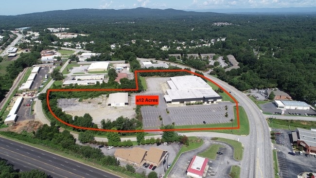
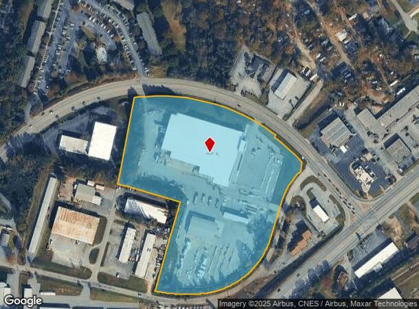
3550 Rutherford Rd
Greenville-Anderson-Mauldin, SC
Alta Ascm As Built Survey For Kyrus Corp
T029.04-01-034.15
MAP T029.04
Publicstorage
Greenville
X
South Carolina
45045C0337E
034.15
2025
11.90 AC
2024
Rt 29 Rutherford Rd
002704
Greenville/Spartanburg
DEMOGRAPHICS near 3550 Rutherford Rd
1 Mile
3 Mile
5 Mile
2024 Total Population
6,264
52,853
131,598
2029 Population
6,836
57,842
144,318
Pop Growth 2024-2029
+ 9.13%
+ 9.44%
+ 9.67%
Average Age
41
40
40
2024 Total Households
2,556
21,174
53,557
HH Growth 2024-2029
+ 9.19%
+ 9.51%
+ 9.78%
Median Household Inc
$63,600
$67,353
$70,863
Avg Household Size
2.40
2.40
2.40
2024 Avg HH Vehicles
2.00
2.00
2.00
Median Home Value
$187,109
$239,080
$266,110
Median Year Built
1977
1980
1984
Nearby Places
Map Layers
Map Styles
 Street
 Aerial
- Restaurants
- Banks
- Shops
- Fitness
- Groceries
PUBLIC TRANSPORTATION
COMMUTER RAIL
DRIVE
WALK
Distance
15 min
7.2 mi
AIRPORT
Greenville Spartanburg International
DRIVE
WALK
Distance
Greenville Spartanburg International
15 min
8.3 mi
SALE & LEASE HISTORY
LISTING DATE
SALE/LEASE

Sep 04, 2018
For Sale
Oct 17, 2017
For Lease
Jun 29, 2017
For Sale
Aug 02, 2017
For Sale
Nearby Properties
Address
Land Use
TOTAL SIZE
Lot Size
Zoning
Address
Land Use
TOTAL SIZE
Lot Size
Zoning
11.80 AC
R10
Address
Land Use
TOTAL SIZE
Lot Size
Zoning
11.30 AC
R10
Address
Land Use
TOTAL SIZE
Lot Size
Zoning
4.95 AC
C1
Address
Land Use
TOTAL SIZE
Lot Size
Zoning
25.70 AC
R20
Address
Land Use
TOTAL SIZE
Lot Size
Zoning
8.98 AC
C1
Address
Land Use
TOTAL SIZE
Lot Size
Zoning
8.95 AC
OD
Address
Land Use
TOTAL SIZE
Lot Size
Zoning
26.30 AC
R20
Address
Land Use
TOTAL SIZE
Lot Size
Zoning
41.90 AC
RMA
Address
Land Use
TOTAL SIZE
Lot Size
Zoning
3.40 AC
C2
Address
Land Use
TOTAL SIZE
Lot Size
Zoning
58.81 AC
R15
Address
Land Use
TOTAL SIZE
Lot Size
Zoning
15.83 AC
RM
Address
Land Use
TOTAL SIZE
Lot Size
Zoning
3.50 AC
C2
Address
Land Use
TOTAL SIZE
Lot Size
Zoning
1.20 AC
I1
Address
Land Use
TOTAL SIZE
Lot Size
Zoning
3.70 AC
C2
Address
Land Use
TOTAL SIZE
Lot Size
Zoning
16.40 AC
PDC
Address
Land Use
TOTAL SIZE
Lot Size
Zoning
8.10 AC
I1
Address
Land Use
TOTAL SIZE
Lot Size
Zoning
21.65 AC
RM7
Address
Land Use
TOTAL SIZE
Lot Size
Zoning
6.10 AC
C2
Address
Land Use
TOTAL SIZE
Lot Size
Zoning
1.03 AC
RM
Address
Land Use
TOTAL SIZE
Lot Size
Zoning
14.78 AC
I1
Address
Land Use
TOTAL SIZE
Lot Size
Zoning
5.21 AC
C2
Address
Land Use
TOTAL SIZE
Lot Size
Zoning
9.14 AC
R75
Address
Land Use
TOTAL SIZE
Lot Size
Zoning
3.11 AC
I1
Address
Land Use
TOTAL SIZE
Lot Size
Zoning
12 AC
RM
Address
Land Use
TOTAL SIZE
Lot Size
Zoning
12.30 AC
I1
Address
Land Use
TOTAL SIZE
Lot Size
Zoning
2,323 SF
23.11 AC
R20
Address
Land Use
TOTAL SIZE
Lot Size
Zoning
11.90 AC
R12
Address
Land Use
TOTAL SIZE
Lot Size
Zoning
1.70 AC
R75
Address
Land Use
TOTAL SIZE
Lot Size
Zoning
9.17 AC
RM
Address
Land Use
TOTAL SIZE
Lot Size
Zoning
17.32 AC
C3
The World's #1 Commercial Real Estate Marketplace
Connect with us
© 2025 CoStar Group
The information above has been obtained from sources believed reliable. While we do not doubt its accuracy we have not verified it and make no guarantee, warranty or representation about it. It is your responsibility to independently confirm its accuracy and completeness. Any projections, opinions, assumptions, or estimates used are for example only and do not represent the current or future performance of the property. The value of this transaction to you depends on tax and other factors which should be evaluated by your tax, financial, and legal advisors. You and your advisors should conduct a careful, independent investigation of the property to determine to your satisfaction the suitability of the property for your needs.