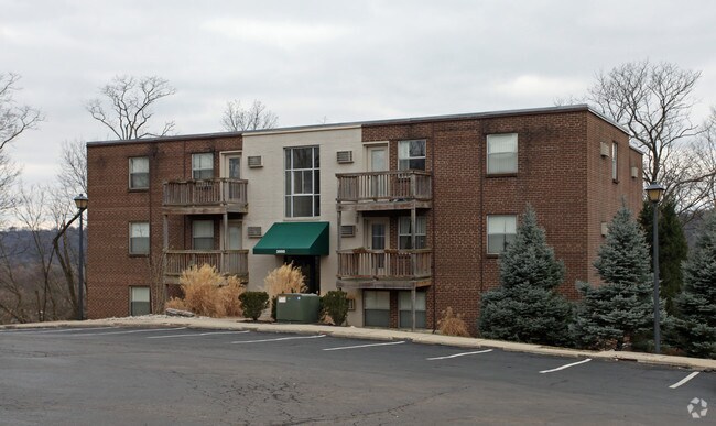
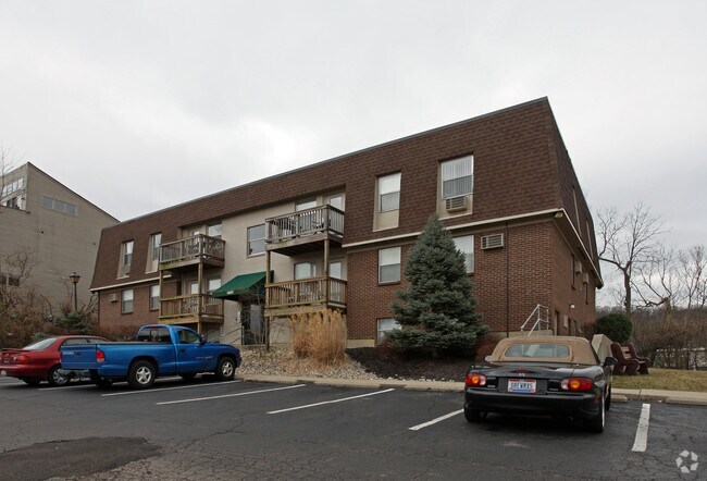
Property Record
3551 Handman Ave, Cincinnati, OH 45226

NEARBY LISTINGS FOR SALE OR LEASE
Property Detail
3551 Handman Ave
Cincinnati, OH-KY-IN
Lts In Cottage Hill Sub
028-0005-0125
SS HANDMAN AV 30.38 X 55.58 IRR PT LOT 37 COTTAGE HILL SUB BLK E
Apartment
Hamilton
X
Ohio
39061C0356G
37
2024
2.41 AC
2024
Columbia-Tusculum
004703
Cincinnati/Dayton
9,954 SF
DEMOGRAPHICS near 3551 Handman Ave
1 Mile
3 Mile
5 Mile
2024 Total Population
6,762
82,696
282,533
2029 Population
6,696
82,526
283,567
Pop Growth 2024-2029
(0.98%)
(0.21%)
+ 0.37%
Average Age
39
39
38
2024 Total Households
3,244
39,520
127,329
HH Growth 2024-2029
(1.11%)
(0.43%)
+ 0.38%
Median Household Inc
$107,853
$82,287
$63,928
Avg Household Size
2.00
2.00
2.00
2024 Avg HH Vehicles
2.00
2.00
2.00
Median Home Value
$484,978
$296,617
$255,056
Median Year Built
1955
1948
1950
Nearby Places
Map Layers
Map Styles
 Street
 Aerial
- Restaurants
- Banks
- Shops
- Fitness
- Groceries
PUBLIC TRANSPORTATION
COMMUTER RAIL
Cincinnati Union Terminal (Cardinal - Amtrak)
DRIVE
WALK
Distance
Cincinnati Union Terminal (Cardinal - Amtrak)
13 min
6.9 mi
AIRPORT
Cincinnati/Northern Kentucky International
DRIVE
WALK
Distance
Cincinnati/Northern Kentucky International
34 min
18.9 mi
Freight Ports
Port of Toledo
DRIVE
WALK
Distance
Port of Toledo
246 min
205.4 mi
Nearby Properties
Address
Land Use
TOTAL SIZE
Lot Size
Zoning
Address
Land Use
TOTAL SIZE
Lot Size
Zoning
13.80 AC
Address
Land Use
TOTAL SIZE
Lot Size
Zoning
27.30 AC
M2
Address
Land Use
TOTAL SIZE
Lot Size
Zoning
153,312 SF
4 AC
Address
Land Use
TOTAL SIZE
Lot Size
Zoning
11.68 AC
Address
Land Use
TOTAL SIZE
Lot Size
Zoning
26,453 SF
19.91 AC
M2
Address
Land Use
TOTAL SIZE
Lot Size
Zoning
60,772 SF
0.78 AC
Address
Land Use
TOTAL SIZE
Lot Size
Zoning
148,748 SF
24.90 AC
CGA
Address
Land Use
TOTAL SIZE
Lot Size
Zoning
3.17 AC
R2PUD
Address
Land Use
TOTAL SIZE
Lot Size
Zoning
10.76 AC
Address
Land Use
TOTAL SIZE
Lot Size
Zoning
119,574 SF
10.40 AC
Address
Land Use
TOTAL SIZE
Lot Size
Zoning
Address
Land Use
TOTAL SIZE
Lot Size
Zoning
70,541 SF
7.08 AC
Address
Land Use
TOTAL SIZE
Lot Size
Zoning
109,000 SF
3.28 AC
Address
Land Use
TOTAL SIZE
Lot Size
Zoning
25,740 SF
0.07 AC
Address
Land Use
TOTAL SIZE
Lot Size
Zoning
Address
Land Use
TOTAL SIZE
Lot Size
Zoning
6.93 AC
MG
Address
Land Use
TOTAL SIZE
Lot Size
Zoning
12.46 AC
Address
Land Use
TOTAL SIZE
Lot Size
Zoning
15,892 SF
0.46 AC
Address
Land Use
TOTAL SIZE
Lot Size
Zoning
Address
Land Use
TOTAL SIZE
Lot Size
Zoning
2,916 SF
27.68 AC
Address
Land Use
TOTAL SIZE
Lot Size
Zoning
89,925 SF
1.72 AC
Address
Land Use
TOTAL SIZE
Lot Size
Zoning
3.34 AC
Address
Land Use
TOTAL SIZE
Lot Size
Zoning
83,122 SF
1.99 AC
Address
Land Use
TOTAL SIZE
Lot Size
Zoning
24,572 SF
4.70 AC
Address
Land Use
TOTAL SIZE
Lot Size
Zoning
22,188 SF
8.88 AC
Address
Land Use
TOTAL SIZE
Lot Size
Zoning
3,864 SF
0.15 AC
PD
Address
Land Use
TOTAL SIZE
Lot Size
Zoning
33,468 SF
1.04 AC
Address
Land Use
TOTAL SIZE
Lot Size
Zoning
2.59 AC
Address
Land Use
TOTAL SIZE
Lot Size
Zoning
2.17 AC
O
Address
Land Use
TOTAL SIZE
Lot Size
Zoning
9,515 SF
19.13 AC
The World's #1 Commercial Real Estate Marketplace
Connect with us
© 2025 CoStar Group
The information above has been obtained from sources believed reliable. While we do not doubt its accuracy we have not verified it and make no guarantee, warranty or representation about it. It is your responsibility to independently confirm its accuracy and completeness. Any projections, opinions, assumptions, or estimates used are for example only and do not represent the current or future performance of the property. The value of this transaction to you depends on tax and other factors which should be evaluated by your tax, financial, and legal advisors. You and your advisors should conduct a careful, independent investigation of the property to determine to your satisfaction the suitability of the property for your needs.