Property Record
0 Fairmont Pkwy, La Porte, TX 77571
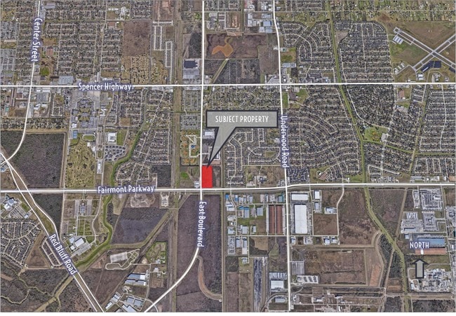

Property Detail
0 Fairmont Pkwy
Houston-Pasadena-The Woodlands, TX
TR 712 LA PORTE OUTLOTS
0231460000712
HARRIS
Commercialacreage
Texas
B and X Area of moderate flood hazard, usually the area between the limits of the 100-year and 500-year floods.
8.24 AC
2025
Gulf Freeway/Pasadena
2025
Houston
343200
NEARBY LISTINGS FOR SALE OR LEASE
DEMOGRAPHICS near 0 Fairmont Pkwy
1 mile
3 mile
5 mile
2025 Total Population
7,282
63,859
142,736
2030 Population
7,816
68,288
152,569
Pop Growth 2025-2030
+ 7.33%
+ 6.94%
+ 6.89%
Average Age
39
39
39
2025 Total Households
2,621
22,435
50,700
HH Growth 2025-2030
+ 7.55%
+ 7.11%
+ 6.99%
Median Household Inc
$58,395
$96,365
$93,524
Avg Household Size
2.70
2.80
2.80
2025 Avg HH Vehicles
2.00
2.00
2.00
Median Home Value
$236,415
$279,052
$287,900
Median Year Built
1991
1989
1987
Nearby Places
Map Layers
Map Styles
 Street
 Aerial
Layers
 Traffic
 Biking
Places
Listings with unknown addresses are not visible on the map
- Restaurants
- Banks
- Shops
- Fitness
- Groceries
PUBLIC TRANSPORTATION
AIRPORT
William P Hobby
Drive
Walk
Distance
William P Hobby
27 min
13.2 mi
George Bush Intcntl/Houston
Drive
Walk
Distance
George Bush Intcntl/Houston
44 min
34.0 mi
Freight Ports
Port of Houston
Drive
Walk
Distance
Port of Houston
27 min
15.6 mi
SALE & LEASE HISTORY
LISTING DATE
SALE/LEASE

Jun 06, 2018
For Sale
Nearby Properties
Address
Land Use
TOTAL SIZE
Lot Size
Zoning
Address
Land Use
TOTAL SIZE
Lot Size
Zoning
Address
Land Use
TOTAL SIZE
Lot Size
Zoning
Address
Land Use
TOTAL SIZE
Lot Size
Zoning
20.83 AC
Address
Land Use
TOTAL SIZE
Lot Size
Zoning
47.21 AC
Address
Land Use
TOTAL SIZE
Lot Size
Zoning
914.75 AC
Address
Land Use
TOTAL SIZE
Lot Size
Zoning
61.40 AC
Address
Land Use
TOTAL SIZE
Lot Size
Zoning
767,630 SF
41.71 AC
Address
Land Use
TOTAL SIZE
Lot Size
Zoning
748,500 SF
42.13 AC
Address
Land Use
TOTAL SIZE
Lot Size
Zoning
411,864 SF
12.61 AC
Address
Land Use
TOTAL SIZE
Lot Size
Zoning
562,760 SF
21.90 AC
Address
Land Use
TOTAL SIZE
Lot Size
Zoning
602,060 SF
34.15 AC
Address
Land Use
TOTAL SIZE
Lot Size
Zoning
348,294 SF
18.02 AC
Address
Land Use
TOTAL SIZE
Lot Size
Zoning
319,549 SF
20.70 AC
Address
Land Use
TOTAL SIZE
Lot Size
Zoning
102.68 AC
Address
Land Use
TOTAL SIZE
Lot Size
Zoning
371,097 SF
10.32 AC
Address
Land Use
TOTAL SIZE
Lot Size
Zoning
54.49 AC
Address
Land Use
TOTAL SIZE
Lot Size
Zoning
Address
Land Use
TOTAL SIZE
Lot Size
Zoning
932.50 AC
Address
Land Use
TOTAL SIZE
Lot Size
Zoning
48.84 AC
Address
Land Use
TOTAL SIZE
Lot Size
Zoning
932.50 AC
Address
Land Use
TOTAL SIZE
Lot Size
Zoning
403,572 SF
24.68 AC
Address
Land Use
TOTAL SIZE
Lot Size
Zoning
2.17 AC
Address
Land Use
TOTAL SIZE
Lot Size
Zoning
371,072 SF
19.71 AC
Address
Land Use
TOTAL SIZE
Lot Size
Zoning
45.18 AC
Address
Land Use
TOTAL SIZE
Lot Size
Zoning
359,223 SF
17.24 AC
Address
Land Use
TOTAL SIZE
Lot Size
Zoning
112.75 AC
Address
Land Use
TOTAL SIZE
Lot Size
Zoning
369,855 SF
21.68 AC
Address
Land Use
TOTAL SIZE
Lot Size
Zoning
356,565 SF
18.07 AC
Address
Land Use
TOTAL SIZE
Lot Size
Zoning
283,010 SF
14.61 AC
Address
Land Use
TOTAL SIZE
Lot Size
Zoning
46.57 AC
The World's #1 Commercial Real Estate Marketplace
Connect with us
© 2026 CoStar Group
The information above has been obtained from sources believed reliable. While we do not doubt its accuracy we have not verified it and make no guarantee, warranty or representation about it. It is your responsibility to independently confirm its accuracy and completeness. Any projections, opinions, assumptions, or estimates used are for example only and do not represent the current or future performance of the property. The value of this transaction to you depends on tax and other factors which should be evaluated by your tax, financial, and legal advisors. You and your advisors should conduct a careful, independent investigation of the property to determine to your satisfaction the suitability of the property for your needs.