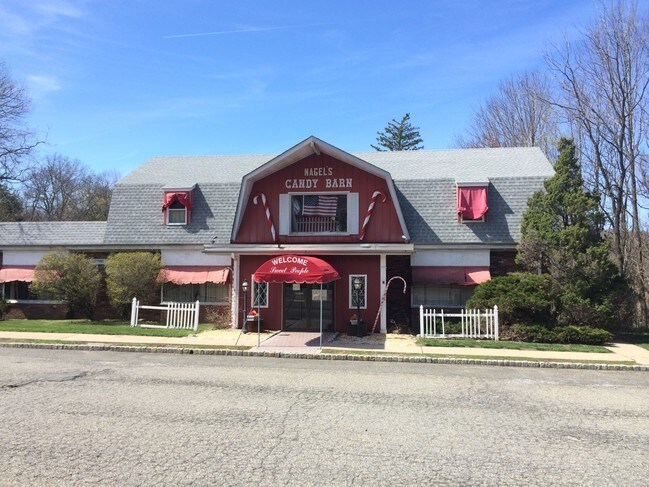
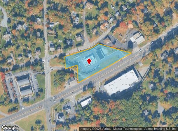
Property Record
358 State Route 10, Randolph, NJ 07869
NEARBY LISTINGS FOR SALE OR LEASE
Property Detail
358 State Route 10
Newark, NJ-PA
ADDITIONAL LOTS: 2 B107 L5
32-00137-0000-00005
Morris
Commercialnec
New Jersey
2024
5
2025
2.70 AC
045603
Western Morris
16,860 SF
Northern New Jersey
DEMOGRAPHICS near 358 State Route 10
1 Mile
3 Mile
5 Mile
2024 Total Population
11,097
63,358
131,787
2029 Population
11,044
63,160
131,704
Pop Growth 2024-2029
(0.48%)
(0.31%)
(0.06%)
Average Age
38
40
42
2024 Total Households
4,045
21,729
47,697
HH Growth 2024-2029
(0.72%)
(0.38%)
(0.06%)
Median Household Inc
$82,606
$101,409
$118,092
Avg Household Size
2.70
2.80
2.70
2024 Avg HH Vehicles
2.00
2.00
2.00
Median Home Value
$369,191
$432,685
$454,522
Median Year Built
1971
1971
1969
Nearby Places
Map Layers
Map Styles
 Street
 Aerial
- Restaurants
- Banks
- Shops
- Fitness
- Groceries
PUBLIC TRANSPORTATION
COMMUTER RAIL
Dover (Montclair-Boonton Line - NJ Transit Commuter Rail (NJ Transit), Morris & Essex Morristown Line - NJ Transit Commuter Rail (NJ Transit))
DRIVE
WALK
Distance
Dover (Montclair-Boonton Line - NJ Transit Commuter Rail (NJ Transit), Morris & Essex Morristown Line - NJ Transit Commuter Rail (NJ Transit))
5 min
1.7 mi
Mount Tabor (Morris & Essex Morristown Line - NJ Transit Commuter Rail (NJ Transit))
DRIVE
WALK
Distance
Mount Tabor (Morris & Essex Morristown Line - NJ Transit Commuter Rail (NJ Transit))
11 min
5.4 mi
AIRPORT
Newark Liberty International
DRIVE
WALK
Distance
Newark Liberty International
38 min
29.6 mi
Freight Ports
Maher Terminal
DRIVE
WALK
Distance
Maher Terminal
42 min
30.2 mi
SALE & LEASE HISTORY
LISTING DATE
SALE/LEASE

Sep 28, 2016
For Sale
Nearby Properties
Address
Land Use
TOTAL SIZE
Lot Size
Zoning
Address
Land Use
TOTAL SIZE
Lot Size
Zoning
222.79 AC
R1
Address
Land Use
TOTAL SIZE
Lot Size
Zoning
401,303 SF
59.54 AC
R-B
Address
Land Use
TOTAL SIZE
Lot Size
Zoning
64.62 AC
R3
Address
Land Use
TOTAL SIZE
Lot Size
Zoning
30.13 AC
I-3
Address
Land Use
TOTAL SIZE
Lot Size
Zoning
95,368 SF
33.81 AC
RMF8
Address
Land Use
TOTAL SIZE
Lot Size
Zoning
28.62 AC
OSGU
Address
Land Use
TOTAL SIZE
Lot Size
Zoning
197,412 SF
28.60 AC
OSGU
Address
Land Use
TOTAL SIZE
Lot Size
Zoning
23.66 AC
I1
Address
Land Use
TOTAL SIZE
Lot Size
Zoning
20.05 AC
R-1
Address
Land Use
TOTAL SIZE
Lot Size
Zoning
97,716 SF
60.89 AC
0-2
Address
Land Use
TOTAL SIZE
Lot Size
Zoning
26,967 SF
14.06 AC
OB-4
Address
Land Use
TOTAL SIZE
Lot Size
Zoning
Address
Land Use
TOTAL SIZE
Lot Size
Zoning
156,564 SF
19.66 AC
B-2
Address
Land Use
TOTAL SIZE
Lot Size
Zoning
44,600 SF
18.62 AC
R-B
Address
Land Use
TOTAL SIZE
Lot Size
Zoning
195,773 SF
43.54 AC
R-4
Address
Land Use
TOTAL SIZE
Lot Size
Zoning
270,140 SF
51.78 AC
R-1B
Address
Land Use
TOTAL SIZE
Lot Size
Zoning
18.35 AC
RMF8
Address
Land Use
TOTAL SIZE
Lot Size
Zoning
180,636 SF
65.98 AC
I
Address
Land Use
TOTAL SIZE
Lot Size
Zoning
Address
Land Use
TOTAL SIZE
Lot Size
Zoning
19,106 SF
19.25 AC
R-B
Address
Land Use
TOTAL SIZE
Lot Size
Zoning
19.47 AC
R-4
Address
Land Use
TOTAL SIZE
Lot Size
Zoning
8.08 AC
I-1
Address
Land Use
TOTAL SIZE
Lot Size
Zoning
153,609 SF
17.54 AC
R-B
Address
Land Use
TOTAL SIZE
Lot Size
Zoning
13.53 AC
R10
Address
Land Use
TOTAL SIZE
Lot Size
Zoning
261,582 SF
18.38 AC
R-B
Address
Land Use
TOTAL SIZE
Lot Size
Zoning
25.95 AC
I-1
Address
Land Use
TOTAL SIZE
Lot Size
Zoning
38.15 AC
R-1
Address
Land Use
TOTAL SIZE
Lot Size
Zoning
199,694 SF
29.23 AC
B-3
Address
Land Use
TOTAL SIZE
Lot Size
Zoning
30.90 AC
I-2
Address
Land Use
TOTAL SIZE
Lot Size
Zoning
16.21 AC
R-4
The World's #1 Commercial Real Estate Marketplace
Connect with us
© 2025 CoStar Group
The information above has been obtained from sources believed reliable. While we do not doubt its accuracy we have not verified it and make no guarantee, warranty or representation about it. It is your responsibility to independently confirm its accuracy and completeness. Any projections, opinions, assumptions, or estimates used are for example only and do not represent the current or future performance of the property. The value of this transaction to you depends on tax and other factors which should be evaluated by your tax, financial, and legal advisors. You and your advisors should conduct a careful, independent investigation of the property to determine to your satisfaction the suitability of the property for your needs.