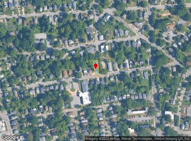
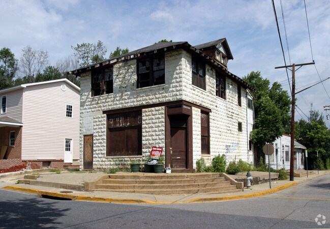
Property Record
3608 Taylor St, Brentwood, MD 20722

NEARBY LISTINGS FOR SALE OR LEASE
Property Detail
3608 Taylor St
Washington-Arlington-Alexandria, DC-VA-MD-WV
Brentwood Cos Sub
17-1836691
THE BRENTWOOD COMPAN S 70 FT LOT 14 N CONF USE-HOUSE
Commercialnec
Prince George's
X
Maryland
24033C0129E
14
2024
0.07 AC
2025
College Park
804600
Washington, DC
1,744 SF
DEMOGRAPHICS near 3608 Taylor St
1 Mile
3 Mile
5 Mile
2024 Total Population
23,831
207,170
719,985
2029 Population
22,865
197,494
677,113
Pop Growth 2024-2029
(4.05%)
(4.67%)
(5.95%)
Average Age
39
37
37
2024 Total Households
8,917
74,386
288,578
HH Growth 2024-2029
(4.34%)
(5.37%)
(7.03%)
Median Household Inc
$66,446
$69,935
$85,500
Avg Household Size
2.60
2.60
2.30
2024 Avg HH Vehicles
1.00
1.00
1.00
Median Home Value
$456,578
$461,810
$514,130
Median Year Built
1949
1957
1958
Nearby Places
Map Layers
Map Styles
 Street
 Aerial
- Restaurants
- Banks
- Shops
- Fitness
- Groceries
PUBLIC TRANSPORTATION
COMMUTER RAIL
Riverdale (Camden Line - Maryland Area Regional Commuter Trains (The MARC))
DRIVE
WALK
Distance
Riverdale (Camden Line - Maryland Area Regional Commuter Trains (The MARC))
8 min
2.5 mi
DRIVE
WALK
Distance
11 min
3.7 mi
AIRPORT
Ronald Reagan Washington Ntl
DRIVE
WALK
Distance
Ronald Reagan Washington Ntl
22 min
10.3 mi
Baltimore/Washington International Thurgood Marshall
DRIVE
WALK
Distance
Baltimore/Washington International Thurgood Marshall
41 min
27.0 mi
Washington Dulles International
DRIVE
WALK
Distance
Washington Dulles International
55 min
33.1 mi
Freight Ports
Port of Baltimore
DRIVE
WALK
Distance
Port of Baltimore
50 min
33.3 mi
Nearby Properties
Address
Land Use
TOTAL SIZE
Lot Size
Zoning
Address
Land Use
TOTAL SIZE
Lot Size
Zoning
58,289 SF
418.97 AC
MU-4;PDR-1
Address
Land Use
TOTAL SIZE
Lot Size
Zoning
1,583,364 SF
276.66 AC
UNZONED
Address
Land Use
TOTAL SIZE
Lot Size
Zoning
95.32 AC
RA-1
Address
Land Use
TOTAL SIZE
Lot Size
Zoning
1,835,827 SF
34.66 AC
UNZONED
Address
Land Use
TOTAL SIZE
Lot Size
Zoning
2,985,682 SF
4.33 AC
RSF65
Address
Land Use
TOTAL SIZE
Lot Size
Zoning
248,643 SF
8.66 AC
RA-1
Address
Land Use
TOTAL SIZE
Lot Size
Zoning
1,201,133 SF
41.56 AC
RTOHC
Address
Land Use
TOTAL SIZE
Lot Size
Zoning
869,190 SF
4.97 AC
RA-1
Address
Land Use
TOTAL SIZE
Lot Size
Zoning
74,664 SF
1.83 AC
RTOLE
Address
Land Use
TOTAL SIZE
Lot Size
Zoning
41.12 AC
RA-1
Address
Land Use
TOTAL SIZE
Lot Size
Zoning
327,745 SF
9.39 AC
RF-1
Address
Land Use
TOTAL SIZE
Lot Size
Zoning
944,105 SF
23.09 AC
CGO
Address
Land Use
TOTAL SIZE
Lot Size
Zoning
330,003 SF
1.74 AC
RTOLE
Address
Land Use
TOTAL SIZE
Lot Size
Zoning
326,985 SF
1.13 AC
MU-6B
Address
Land Use
TOTAL SIZE
Lot Size
Zoning
169,500 SF
9.14 AC
RA-1
Address
Land Use
TOTAL SIZE
Lot Size
Zoning
492,835 SF
21.61 AC
RA-1
Address
Land Use
TOTAL SIZE
Lot Size
Zoning
4,924 SF
53.06 AC
R-3
Address
Land Use
TOTAL SIZE
Lot Size
Zoning
102,968 SF
18.08 AC
RF-1
Address
Land Use
TOTAL SIZE
Lot Size
Zoning
62.03 AC
UNZONED
Address
Land Use
TOTAL SIZE
Lot Size
Zoning
8,060 SF
1.63 AC
LTOE
Address
Land Use
TOTAL SIZE
Lot Size
Zoning
393,700 SF
1.30 AC
RTOLC
Address
Land Use
TOTAL SIZE
Lot Size
Zoning
259,000 SF
1.91 AC
MU-7B
Address
Land Use
TOTAL SIZE
Lot Size
Zoning
3.64 AC
RTOHC
Address
Land Use
TOTAL SIZE
Lot Size
Zoning
0.30 AC
PDR-2
Address
Land Use
TOTAL SIZE
Lot Size
Zoning
578,232 SF
1.43 AC
RTOHC
Address
Land Use
TOTAL SIZE
Lot Size
Zoning
337,500 SF
12.48 AC
RTOLE
Address
Land Use
TOTAL SIZE
Lot Size
Zoning
270,109 SF
17.63 AC
PDR-1;PDR-
Address
Land Use
TOTAL SIZE
Lot Size
Zoning
396 SF
6.80 AC
RTOHE
Address
Land Use
TOTAL SIZE
Lot Size
Zoning
9,184 SF
2.50 AC
LTOE
Address
Land Use
TOTAL SIZE
Lot Size
Zoning
185,000 SF
2.07 AC
PDR-1
The World's #1 Commercial Real Estate Marketplace
Connect with us
© 2025 CoStar Group
The information above has been obtained from sources believed reliable. While we do not doubt its accuracy we have not verified it and make no guarantee, warranty or representation about it. It is your responsibility to independently confirm its accuracy and completeness. Any projections, opinions, assumptions, or estimates used are for example only and do not represent the current or future performance of the property. The value of this transaction to you depends on tax and other factors which should be evaluated by your tax, financial, and legal advisors. You and your advisors should conduct a careful, independent investigation of the property to determine to your satisfaction the suitability of the property for your needs.